Who What Where WhenREMOVE |
Author
[Morris, Walter J., United States. War Department]
Full Title
Bb. Plan of the battles on Stone's River before Murfreesborough. Gen. Bragg, commdg. Confederate Army, Maj. Gen. Rosecrans, commdg. Federal Army, Dec. 31, 1862, Jan. 1, 2, 3, 1863. ... by Walter J. Morris ... (with) Position of the divisions of Humphreys, Whipple, Griffin and Sykes at the battle of Fredericksburg on Dec. 13th, 1862. (with) V. Plan of Sabine Pass, of its defenses and means of communication. J. Kellersberg(er) ... October 15th, 1863. (with) Rebel fortifications, Grand Gulf, Miss. Surveyed May, 1863, drawn October, 1863 by H.A. Ulffers, Asst. Engr. (with) Skirmishes near Liberty Gap, Tenn., June 24-26, 1863 ... report of Brig. Gen St. John R. Liddell, C.S. Army. (with) Map of the approaches to Little Rock, Ark., made under directions from Maj. Gen. Sterling Price ... by Capt. T.J. Mackey, C.S. Engrs., August, 1863 ... Julius Bien & Co., Lith., N.Y. (1891-1895)
Publisher
U.S. Government Printing Office
Author
[Brown, S. Howell, Confederate States of America. Army of Northern Virginia, Confederate States of America. Army]
Full Title
Map of the battle-field of Gettysburg with positions of troops, July 2nd, 1863. Topl. Office, A.N.V., by L. Howell Brown ... copied by Hoffmann. Accompanying report of Gen. R.E. Lee, C.S. Army. (with) Sketch of the battle of Gettysburg, July 1st, 2nd and 3rd, 1863 to accompany report of Lieut. Gen. R.S. Ewell ... by Jed. Hotchkiss. (with) Sketch of the second battle of Winchester, June 13th, 14th and 15th, 1863 ... by Jed. Hotchkiss. (with. Marietta Region) Accompanying report of Brig. Gen. K. Garrard. (with Dallas Region) Marked "McPherson" by Gen. Sherman. (with Dallas Region) Marked "McPherson" by Gen. Sherman. (with) Sketch of routes, 2nd Corps A.N.V. from Fredericksburg, Va. to Gettysburg, Pa. and return to Orange C.H., Va. from June 4th 1863 to August 1st, 1863. To accompany report of Lieut. Gen. R.S. Ewell ... by Jed. Hotchkiss. (with) Texas Coast showing points of occupation of expedition under Maj. Gen. N.P. Banks, November 1863. (with Dallas Region). Marked "McPherson" by Gen. Sherman. Julius Bien & Co., Lith., N.Y. (1891-1895)
Publisher
U.S. Government Printing Office
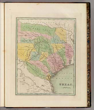
Author
United States. War Department
Full Title
Map of Texas and part of New Mexico, compiled in the Bureau of Topographl. Engrs. chiefly for military purposes. Information on this map furnished by Wm. E. Young, C.E. and compiled under the direction of Maj. D.C. Houston, Chief Engr., Dept. of the Gulf. Accompanying letter of Gen. N.P. Banks ... (with) Plan of the battle-field at New Creek, W. Va., August 4th, 1864. (with) Plan of the battle-field at Pleasant Mills near Cumberland, Md., August 1st, 1864. Made by F.M. Knight. ... Julius Bien & Co., Lith., N.Y. (1891-1895)
Publisher
U.S. Government Printing Office
Author
[United States. War Department, Walker, Tipton]
Full Title
Coast of Texas and its defenses, Capt. Tipton Walker, Chief of Topographical Bureau of Texas, New Mexico and Arizona, drawn by P. Helferich, Asst. Engr. 1864. (with) Engineer Office, 10th Army Corps, sketch no. 8 of road between Bermuda Hundred and enemy's first line of intrenchments on the north and Petersburg on the south. T.B. Brooks, Maj. A.D.C. and Directing Engineer. (with Marietta, Ga., June 10-July 3, 1864). Original marked "Thomas and Schofield." (with Marietta, Ga., June 10-July 3, 1864). Original marked "Garrard." (with) Schofield crossing the Chattahoochee. (with Marietta, Ga., June 10-July 3, 1864). (with) No. 3. Sketch of defensive works at Deep Bottom, Va. (with) Section through Dutch Gap, James River, Va. (with) Plan of Dutch Gap Canal and fortifications, James River, Va., Sept. 10, 1864. P.S. Michie. (with) No. 2. Sketch of road from pontoon-bridge at Point of Rocks to Petersburg, showing line of works captured by 18th Army Corps. Julius Bien & Co., Lith., N.Y. (1891-1895)
Publisher
U.S. Government Printing Office
Author
Johnson, A.J.
Full Title
Johnson's Texas. Published by A. J. Johnson, New York. 58. 59. Entered according to the Act of Congress, in the year 1866, by A.J. Johnson in the Clerk's Office of the District Court of the United States for the Southern District of New York.
Publisher
A.J. Johnson.
Author
[Bourquin, Frederick, Mitchell, Samuel Augustus, Tanner, Henry S.]
Full Title
Map of Texas from the Most Recent Authoriities. Philadelphia. Published by C.S. Williams, N.E. Corner of Market & 7th Streets. 1845. Entered according to Act of Congress in the 1845 by C.S. Williams, in the Clerk's Office of the District Court of the Eastern District of Pennsylvania. 35.
Publisher
C.S. Williams
Author
Asher & Adams
Full Title
Asher & Adams' Indian Territory and Texas, North West Portion Entered according to Act of Congress 1874 by Asher & Adams in the Office of the Librarian of Congress at Washington.
Publisher
Asher & Adams.
Author
Asher & Adams
Full Title
Asher & Adams' Texas, Eastern Portion. Entered according to Act of Congress 187? by Asher & Adams in the Office of the Librarian of Congress at Washington. (1875)
Publisher
Asher & Adams.
Author
Asher & Adams
Full Title
Asher & Adams' Texas, Western Portion. Entered according to Act of Congress 1874 by Asher & Adams in the Office of the Librarian of Congress at Washington.
Publisher
Asher & Adams.
Author
Fullarton, A. & Co.
Full Title
United States North America According to Calvin, Smith & Tanner. By G.H. Swanston Edinr. The South Central Section Comprising Texas, Louisiana, Mississippi, Arkansas, Western Territory, and part of Missouri. LIX. Engraved by G.H. Swanston Edinburgh. A. Fullarton & Co. Edinburgh, London & Dublin.
Publisher
A. Fullarton & Co.
Author
Fullarton, A. & Co.
Full Title
Southern Ports & Harbours in the United States. By J. Bartholomew, F.R.G.S. (with) eight maps. LXa. A. Fullarton & Co. London and Edinburgh.
Publisher
A. Fullarton & Co.
Full Title
Section along 36th parallel from the Rio Grande to the Canadian Plains. Atlas sheets 69 D and 70 C. Julius Bien, lith. (1881)
Publisher
U.S.
Full Title
Texas. (Published by George F. Cram, Chicago, Ill. 1909)
Publisher
E.A. Davis
Author
Bache, A. D.
Full Title
Preliminary sketch of Galveston Bay, Texas. (with) Clopper's Bar. (with) Red Fish Bar. U.S. Coast Survey. A.D. Bache, Superintendent. 1852. Second edition. (with logo) U.S. Coast Survey Office.
Publisher
U.S.
Author
Flemming, Carl
Full Title
Mexico, Mittel-America, Texas. Lithographie, Druck u. Verlag von C. Flemming in Glogau. (1855)
Publisher
C. Flemming
Author
Flemming, Carl
Full Title
Texas. (with) Plan der Galveston Bay. Druck und Verlag von C. Flemming in Glogau. (1855)
Publisher
C. Flemming
Full Title
Mexico. (with) Texas. (Written and engraved by Jos. Perkins. 1845)
Publisher
Tanner's Geographical Establishment
Author
[Brue, Adrien Hubert, 1786-1832, Picquet, C.]
Full Title
Carte generale des Etats-Unis Mexicains, de la Republique du Texas et des etats de l'Amerique Centrale. (with) Guatemala ou Provinces-Unies de l'Amerique Centrale. Par A. Brue, Geographe du Roi (1825). Revue et augmentee par Ch. Picquet, Geographe du Roi et de Mgr. le Duc d'Orleans. Paris, 1840. Chez Ch. Picquet, Quai Conti No. 17, pres du Pont des Arts.
Publisher
C. Picquet
Author
Rand McNally and Company
Full Title
Rand McNally junior auto road map Texas. Copyright by Rand McNally & Co., Chicago, Ill. (1927)
Publisher
Rand McNally
Author
Rand McNally and Company
Full Title
St. Louis and vicinity. New Orleans and vicinity. Dallas Ft. Worth and vicinity. Portland and vicinity (Oregon). Copyright by Rand McNally & Co., Chicago, Ill. (1927)
Publisher
Rand McNally
Author
Greenleaf, Jeremiah
Full Title
Texas Compiled from the latest and best Authorities.
Publisher
J. Greenleaf.
Author
Colton, G.W.
Full Title
New Map of the State of Texas, Compiled from J. De Cordova's Large Map. No (35-) 36. Entered according to the Act of Congress in the year 1855 by J.H. Colton & Co. in the Clerk's Office of the District Court of the United States for the Southern District of New York.
Publisher
J.H. Colton
Author
[Ives, J.C., Whipple, A.W.]
Full Title
From Fort Smith to the Rio Grande from explorations and surveys made under the direction of the Hon. Jefferson Davis, Secretary of War by Lieut. A.W. Whipple, Topogl. Engrs. and Lieut. J.C. Ives, Topogl. Engrs. A.H. Campbell, Civil Eng. and Surveyor, Asst. Surveyors: Wm. White Jr., N.H. Hutton, and J.P. Sherburne. 1853-4. Explorations and Surveys for a Rail Road Route from the Missisippi (sic) River to the Pacific Ocean, War Department, Route Near the 35th Parallel, Map No. 1. Engr. by Selmar Siebert.
Publisher
[A.O.P. Nicholson I-XI, T. Ford XII.]
Author
Pope, John
Full Title
From the Red River to the Rio Grande; from Explorations and Surveys made under the direction of the Hon. Jefferson Davis, Secretary of War, by Captain John Pope, Corps Topl. Engrs. assisted by Lieutenant Kenner Gerrard, 1st Dragoons. 1854-6. Map and Profile No. 1. Explorations and Surveys for a Railroad Route from the Mississippi River to the Pacific Ocean. War Department. Route near the 32nd parallel.
Publisher
[A.O.P. Nicholson I-XI, T. Ford XII.]
Author
Wyld, James, 1812-1887
Full Title
Republic of Mexico and Texas. J.W. del. (engraved by) Stockley, Sc. London, James Wyld, Charing Cross. (to accompany) An Atlas of the World, Comprehending Separate Maps of its various Countries, Constructed & drawn from the latest Astronomical & Geographical Observations. By James Wyld, Geographer to Her Majesty and H. Late R.H. Prince Albert. London. Published by James Wyld (Successor to Mr. Faden) Charing Cross East. 1864.
Publisher
James Wyld
Author
Leahy, J.F.
Full Title
(Index to) Leahy's Hotel Guide and Railway Distance Maps. Texas.
Publisher
American Hotel register Co.
Author
Leahy, J.F.
Full Title
Leahy's Hotel Guide and Railway Distance Map of the State of Texas. Published by American Hotel Register Company. Leahy Build., 228-234 W. Ontario St., Chicago, Ill. Copyrighted by J.F. Leahy, Jan., 1934. (with two inset maps) North-Western part of Texas, and Rio Grande Valley of Texas.
Publisher
American Hotel register Co.
Author
Leahy, J.F.
Full Title
(Index to) Leahy's Hotel Guide and Railway Distance Maps. Texas. Utah.
Publisher
American Hotel register Co.
Author
[Gray, Ormando Willis, Lloyd, H.H., Walling, H. F.]
Full Title
Atlas of the United States. Texas. (Published by Stedman, Brown & Lyon, Cincinnati. 1872. Entered ... 1872, by H.F. Walling, and O.W. Gray, and H.H. Lloyd & Co. ... Washington)
Publisher
Stedman, Brown & Lyon
Author
Mitchell, Samuel Augustus
Full Title
(Covers to) A New Map of Texas Oregon and California With The Regions Adjoining. Compiled from the most recent authorities. Philadelphia Published by S. Augustus Mitchell N.E. Corner Of Market & Seventh Streets. 1846. Entered ... 1845 by H.N. Burroughs ... Pennsylvania.
Publisher
S.A. Mitchell
Author
W. & A.K. Johnston Limited
Full Title
Oklahoma, Texas (North). Texas (South).
Publisher
W. & A.K. Johnston Limited
Author
Page, H.R. & Co.
Full Title
Map of Texas, Published by H.R. Page & Co., Chicago, Ill, 1886.
Publisher
H.R. Page & Co.
Author
U.S. General Land Office
Full Title
(Map 5 - Texas, Lousiana).
Publisher
Julius Bien
Author
U.S. General Land Office
Full Title
(Map 9 - Texas).
Publisher
Julius Bien
Author
U.S. General Land Office
Full Title
(Map 10 - Texas, New Mexico, Indian Territories, Utah).
Publisher
Julius Bien
Author
Mitchell, Samuel Augustus
Full Title
Map of Texas from the most Recent Authorities. Philadelphia: Published By C.S. Williams, N.E. corner of Market & 7th. Streets. Entered ... 1845 by C.S. Williams ... Pennsylvania. (inset map) Texas North of Red River.
Publisher
S.A. Mitchell
Author
Bradford, Thomas G.
Full Title
Texas. Entered ... 1838, by T.G. Bradford ... Massachusetts. Engraved by G.W. Boynton.
Publisher
[Weeks, Jordan & Co., Wiley and Putnam.]
Author
Mitchell, Samuel Augustus Jr.
Full Title
County map of Texas. (inset map) 35. Galveston Bay and Vicinity. Entered ... 1860 by S. Augustus Mitchell, Jr. ... Pennsylvania.
Publisher
S.A. Mitchell Jr.
Author
Disturnell, John
Full Title
(Covers to) Mapa de los Estados Unidos De Mejico, Segun lo organizado y definido por las varias actas del Congreso de dicha Republica ... Lo Publican J. Disturnell, 102 Broadway. Nuevo York. 1847. Revised Edition. (inset) Carto De Los Caminos &c. Desde Vera Cruz Y Alvarado A Mejico. (inset) Chart of the Bay of Vera Cruz. (inset) Map Showing The Battle Grounds of the 8th and 9th May 1846.
Publisher
J. Disturnell
Author
Disturnell, John
Full Title
Mapa de los Estados Unidos De Mejico, Segun lo organizado y definido por las varias actas del Congreso de dicha Republica ... Lo Publican J. Disturnell, 102 Broadway. Nuevo York. 1847. Revised Edition. (inset) Carto De Los Caminos &c. Desde Vera Cruz Y Alvarado A Mejico. (inset) Chart of the Bay of Vera Cruz. (inset) Map Showing The Battle Grounds of the 8th and 9th May 1846.
Publisher
J. Disturnell
Author
Mitchell, Samuel Augustus Jr.
Full Title
County map of the state of Texas. Showing also portions of the adjoining states and territories. Drawn and engraved by W.H. Gamble, Philadelphia. (with inset) Plan of Galveston and vicinity. Entered ... 1873, by S. Augustus Mitchell ... Washington.
Publisher
S.A. Mitchell Jr.
Author
Mitchell, Samuel Augustus Jr.
Full Title
County map of the State of Texas: showing also portion of the adjoining States and Territories. Drawn and engraved by W.H. Gamble Philadelphia. Entered ... 1876 by S. Augustus Mitchell, . ... Washington. (inset map): Plan of Galveston and vicinity.
Publisher
S.A. Mitchell Jr.
Author
Lothian, John
Full Title
Mexico & Guatimala (Guatemala) with Texas.
Publisher
James MacLeod and Francis Orr & Sons
Author
Johnson, A.J.
Full Title
Johnson's Texas By Johnson & Browning. (with) inset maps: Plan Of Galveston Bay From The U.S. Coast Survey and Plan of Sabine Lake. No. 33.
Publisher
Johnson and Browning
Author
Mitchell, Samuel Augustus
Full Title
Map of Texas. (inset) Texas North of Red River.
Publisher
Thomas, Cowperthwait & Co.
Author
Mitchell, Samuel Augustus
Full Title
Map of Texas. (inset) Texas North of Red River.
Publisher
Thomas, Cowperthwait & Co.
Author
Mitchell, Samuel Augustus
Full Title
Map of the State of Texas from the Latest Authorities, By J.H. Young. J.L. Hazzard Sc. Published by Charles Desilver, Philadelphia. Entered ... 1856 by Charles Desilver ... Pennsylvania. (insets) Map of the Vicinity of Galveston City, and Northern Texas (Panhandle).
Publisher
Charles DeSilver
Author
[Raynal, G.T., Bonne, R.]
Full Title
Le Nouveau Mexique, Avec La Partie Septentrionale De L'Ancien, ou De La Nouvelle Espagne, par M. Bonne, Ingenieur-Hydrographe de la Marine. Grave par Dient. (on upper margin) Liv. VI. et X: No. 28. (on lower margin) 29. (to accompany) Histoire Philosophique et Politique Des Establissements et Du Commerce Des Europeens Dans Les Deux Indes.
Publisher
Jean-Leonard Pellet
|