Who What Where WhenREMOVEWHATShow More |
Author
Johnston, Alexander Keith, 1804-1871
Full Title
United States of North America, eastern states, by Keith Johnston, F.R.S.E. Engraved & printed by W. & A.K. Johnston, Edinburgh. William Blackwood & Sons, Edinburgh & London, (1861)
Publisher
William Blackwood & Sons
Author
[Mitchell, Samuel Augustus, Young, James H.]
Full Title
(Covers to) Mitchell's Traveller's Guide Through The United States, Containing The Principal Cities, Towns, &c. ... Illustrated By An Accurate Map Of The United States. Philadelphia: Thomas, Cowperthwait, & Co. 253 Market Street. (on verso) Entered ... 1836, by Mitchell & Hinman ... Pennsylvania. Stereotyped by John Fagan ... Philadelphia. (with map) Mitchell's Travellers Guide Through The United States. A Map Of The Roads, Distances, Steam Boat & Canal Routes &c. By J.H. Young. Philadelphia. Published by S. Augustus Mitchell. 1843. Engraved On Steel By J.H. Young And D. Haines. Entered ... 1834 by S. Augustus Mitchell ... Pennsylvania. (with 8 inset maps).
Publisher
Thomas, Cowperthwait & Co.
Author
[Mitchell, Samuel Augustus, Young, James H.]
Full Title
(Title page to) Mitchell's Traveller's Guide Through The United States, Containing The Principal Cities, Towns, &c. Alphabetically Arranged; Together with the Stage, Steam-Boat, Canal and Rail-Road Routes, with the Distances, in Miles from Place to Place. Illustrated By An Accurate Map Of The United States. Philadelphia: Thomas, Cowperthwait, & Co. 253 Market Street. 78P. (on verso) Entered ... 1836, by Mitchell & Hinman ... Pennsylvania. Stereotyped by John Fagan ... Philadelphia. (with map) Mitchell's Travellers Guide Through The United States. A Map Of The Roads, Distances, Steam Boat & Canal Routes &c. By J.H. Young. Philadelphia. Published by S. Augustus Mitchell. 1843. Engraved On Steel By J.H. Young And D. Haines. Entered ... 1834 by S. Augustus Mitchell ... Pennsylvania. (with 8 inset maps).
Publisher
Thomas, Cowperthwait & Co.
Author
[Mitchell, Samuel Augustus, Young, James H.]
Full Title
Mitchell's Travellers Guide Through The United States. A Map Of The Roads, Distances, Steam Boat & Canal Routes &c. By J.H. Young. Philadelphia. Published by S. Augustus Mitchell. 1843. Engraved On Steel By J.H. Young And D. Haines. Entered ... 1834 by S. Augustus Mitchell ... Pennsylvania. (with 8 inset maps).
Publisher
Thomas, Cowperthwait & Co.
Author
British North America-U.S. Boundary
Full Title
A Map Of The Frontier Of British North America, And The United States, Describing The Boundary Line as fixed by the Treaty of 1783, which has never been respected by the American Government. Likewise the New Line of Demarcation as now proposed to be established between those States, and the British Provinces intended to secure the Independence of the Indians.
Publisher
N.P.
Author
Bradley, Abraham Junior
Full Title
(Covers to)Map of the United States, Exhibiting the Post-Roads, the situations, connexions and distances of the Post-Offices, Stage Roads, Counties & Principal Rivers By Abraham Bradley Junr. Entered ... 2nd day of June1804, by Abraham Bradley Junr. of the District of Columbia. (inset) Map Of North America.
Publisher
Abraham Bradley
Author
Rand McNally and Company
Full Title
Black and White Mileage Map Of The United States. Rand McNally & Company. Chicago. New York. Copyright by Rand McNally & Co., Chicago & New York. Made in U.S.A. (in red) Maps-Atlases. Rand McNally & Company. Map Systems. Map Headquarters, Buffalo, N.Y. 1054 Ellicott Sq. Bldg. Phone Seneca 0236.
Publisher
Rand McNally and Company
Author
[G.W. & C.B. Colton & Co., Walling, H. F.]
Full Title
Map of the United States of America. Entered according to act of Congress in the year 1873 by G.W. & C.B. Colton & Co ... Washington. (Drawn, compiled, and edited by H.F. Walling, C.E. ... Published by R.M. & S.T. Tackabury, Detroit, Mich. Entered ... 1873, by H.F. Walling ... Washington. The Claremont Manufacturing Company, Claremont, N.H., Book Manufacturers)
Publisher
R.M. & S.T. Tackabury
Author
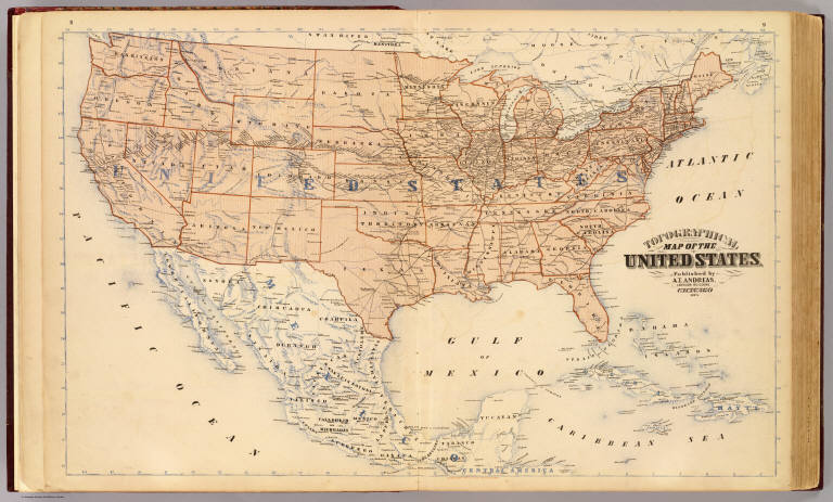
Andreas, A. T. (Alfred Theodore), 1839-1900
Full Title
Topographical map of the United States. Published by A.T. Andreas, Lakeside Building, Chicago, 1873. (Chas. Shober & Co. Proprietors of Chicago Lith. Co.)
Publisher
A.T. Andreas
Author
Andreas, A. T. (Alfred Theodore), 1839-1900
Full Title
Population, United States Census, 1870: Density of population. Foreign population, Colored population, British American population, Swedish and Norwegian population. (Published by A.T. Andreas, Lakeside Building, Chicago, 1874. Chas. Shober & Co. Proprietors of Chicago Lith. Co.)
Publisher
A.T. Andreas
Author
Andreas, A. T. (Alfred Theodore), 1839-1900
Full Title
Agricultural productions colored by grades to show quantity raised in localities, from the ninth census: wheat, hay, corn, cotton, tobacco. (Published by A.T. Andreas, Lakeside Building, Chicago, 1874. Chas. Shober & Co. Proprietors of Chicago Lith. Co.)
Publisher
A.T. Andreas
Author
Andreas, A. T. (Alfred Theodore), 1839-1900
Full Title
Vital statistics, United Census, 1870: Deaths from consumption ... malarial diseases ... enteric cerebro-spinal and typhus fevers ... intestinal diseases. (Published by A.T. Andreas, Lakeside Building, Chicago, 1874. Chas. Shober & Co. Proprietors of Chicago Lith. Co.)
Publisher
A.T. Andreas
Author
Mitchell, Samuel Augustus
Full Title
A New Map of the United States of America. by J.H. Young. Published by Thomas, Cowperthwait & Co. No. 253 Market Street. Philadelphia. Entered ... 1850, by Thomas, Cowperthwait & Co. ... Pennsylvania. (with two inset maps) Gold Regions of California, and District of Columbia.
Publisher
Thomas, Cowperthwait & Co.
Author
U.S. War Department, Topographical Engineers
Full Title
Map Of The United States And Their Territories Between The Mississippi and the Pacific Ocean And Of Part of Mexico. Compiled in the Bureau of the Corps of Topogl. Engs. under a Resolution of the U.S. Senate. From the best authorities which could be obtained. 1850. Engraved by Sherman and Smith, New-York.
Publisher
Sherman and Smith
Author
Bradley, Abraham Junior
Full Title
Map of the United States, Exhibiting the Post-Roads, the situations, connexions and distances of the Post-Offices, Stage Roads, Counties & Principal Rivers By Abraham Bradley Junr. Entered ... 2nd day of June1804, by Abraham Bradley Junr. of the District of Columbia. (inset) Map Of North America. (1812)
Publisher
Abraham Bradley
Author
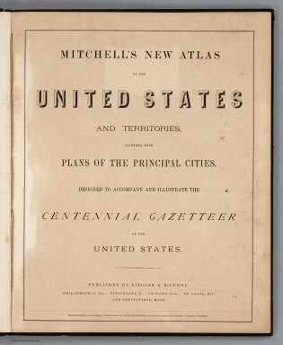
Mitchell, Samuel Augustus Jr.
Full Title
(Title Page) Mitchell's New Atlas Of The United States And Territories, Together With Plans Of The Principal Cities. Designed To Accompany And Illustrate The Centennial Gazetteer Of The United States. Published By Ziegler & McCurdy, Philadelphia, Pa., Cincinnati, O., Chicago, Ill., St. Louis, Mo., And Springfield, Mass. Entered ... 1874, by S. Augustus Mitchell ... Washington.
Publisher
Ziegler & McCurdy
Author
Mitchell, Samuel Augustus Jr.
Full Title
Map of the United States, and Territories together with Canada &c. (inset) Island of Newfoundland. Entered ... 1874 by S. Augustus Mitchell ... Washington.
Publisher
Ziegler & McCurdy
Author
Harrison, Richard Edes
Full Title
Outward From The U.S. (to accompany) Look At The World: The Fortune Atlas For world Strategy. By Richard Edes Harrison. Text by Editor of Fortune. New York: Alfred A. Knopf 1944. (on verso) Copyright 1944 by Time Incorporated.
Publisher
A. A. Knopf
Author
Harrison, Richard Edes
Full Title
The U.S. From The Outside. (to accompany) Look At The World: The Fortune Atlas For world Strategy. By Richard Edes Harrison. Text by Editor of Fortune. New York: Alfred A. Knopf 1944. (on verso) Copyright 1944 by Time Incorporated.
Publisher
A. A. Knopf
Author
Woodbridge, William C.
Full Title
(Text Page to) Tables Exhibiting The Commerce Of The United States. (to accompany) Modern Atlas On A New Plan; To Accompany The System Of Universal Geography, By William Channing Woodbridge ... Exhibiting In Connection With The Outlines Of Countries, The Prevailing Religions, Forms Of Government, And Degrees Of Civilization; The Comparative Size Of Towns, Rivers And Mountains; And The Climates And Productions Of The Earth ... District Of Connecticut, ss. Be It Remembered, That on the twenty-second day of June, in the forty-eighth year of the Independence of the United States of America, William Channing Woodbridge ... and Emma Willard ... have deposited in this Office the title of a book ... Charles A. Ingersoll, Clerk of the District of Connecticut. Hartford: Oliver D. Cooke & Sons, Publishers.
Publisher
Oliver D. Cooke & Sons
Author
Woodbridge, William C.
Full Title
United States. Entered ... 1821, by William.C. Woodbridge ... Connecticut. (to accompany) Modern Atlas On A New Plan; To Accompany The System Of Universal Geography, By William Channing Woodbridge ... Exhibiting In Connection With The Outlines Of Countries, The Prevailing Religions, Forms Of Government, And Degrees Of Civilization; The Comparative Size Of Towns, Rivers And Mountains; And The Climates And Productions Of The Earth ... District Of Connecticut, ss. Be It Remembered, That on the twenty-second day of June, in the forty-eighth year of the Independence of the United States of America, William Channing Woodbridge ... and Emma Willard ... have deposited in this Office the title of a book ... Charles A. Ingersoll, Clerk of the District of Connecticut. Hartford: Oliver D. Cooke & Sons, Publishers. (inset) Northern Division Of The United States.
Publisher
Oliver D. Cooke & Sons
Author
Gibbes, C.D.
Full Title
A New Map Of California. By Charles Drayton Gibbes From his own and other Recent Surveys and Explorations. MDCCCLII. Published by C.D. Gibbes, Stockton, Cal. Sherman & Smith, New York. Entered ... 1852 by Sherman & Smith ... New York. (inset) Map Of The United States Of America, Mexico, Central America, Cuba &c.
Publisher
C.D. Gibbes
Author
Gibbes, C.D.
Full Title
(Covers to) A New Map Of California. By Charles Drayton Gibbes From his own and other Recent Surveys and Explorations. MDCCCLII. Published by C.D. Gibbes, Stockton, Cal. Sherman & Smith, New York. Entered ... 1852 by Sherman & Smith ... New York. (inset) Map Of The United States Of America, Mexico, Central America, Cuba &c.
Publisher
C.D. Gibbes
Author
Johnson, A.J.
Full Title
Coats of Arms (of States) (continued).
Publisher
Johnson and Ward
Author
Johnson, A.J.
Full Title
Johnson's New Military Map of the United States Showing the Forts, Military Posts &c. With Enlarged Plans of Southern Harbors From Authentic Data Obtained at the War Department, Washington, (by) Johnson and Ward. Entered ... One Thousand Eight Hundred & Sixty-one, by A.J. Johnson & Browning ... New York. With 9 inset maps.
Publisher
Johnson and Ward
Author
Garnier, F. A., 1803-1863
Full Title
Amerique Boreale, Nouvle. Bretagne & Canada. Atlas spheroidal & universel de geographie dresse par F.A. Garnier, geographe. Ve. Jules Renouard, Editeur, Rue de Tournon, no. 6, Paris. 1860. Impie. de Louis Antoine, 1, Rue de Cluny, Paris.
Publisher
Veuve Jules Renouard, Libraire
Author
Garnier, F. A., 1803-1863
Full Title
Etats-Unis de l'Amerique du Nord. Limites en 1855. (with) Iles St. Pierre et Miquelon. (with) Partie sud du Territoire de la Floride. Atlas spheroidal & universel de geographie dresse par F.A. Garnier, geographe. Ve. Jules Renouard, Editeur, Rue de Tournon, no. 6, Paris. 1860. Imp. Sarazin, R. Git-le-Coeur, 8, Paris.
Publisher
Veuve Jules Renouard, Libraire
Author
Garnier, F. A., 1803-1863
Full Title
Etats-Unis de l'Amerique du Nord. Limites en 1860. (with) Iles St. Pierre et Miquelon. Atlas spheroidal & universel de geographie dresse par F.A. Garnier, geographe. Ve. Jules Renouard, Editeur, Rue de Tournon, no. 6, Paris. 1860. Imp. Louis Antoine, r. de Cluny, 1, Paris.
Publisher
Veuve Jules Renouard, Libraire
Author
Southern Pacific Company
Full Title
(Covers to:) California, Texas, Mexico And Arizona Southern Pacific Co. "Sunset route" from New Orleans to the Pacific Coast ... January, 1892. American Bank Note Co., N.Y.
Publisher
Poole Brothers.
Author
Southern Pacific Company
Full Title
California, Texas, Mexico And Arizona Southern Pacific Co. "Sunset route" from New Orleans to the Pacific Coast ... January, 1892. American Bank Note Co., N.Y.
Publisher
Poole Brothers.
Author
Southern Pacific Company
Full Title
Correct map of the railway & steamship lines operated by the Southern Pacific Company [United States and Mexico]. Poole Bros., Map Engravers, Chicago. (inset) County map of Texas showing the Atlantic System of the Southern Pacific Company. (inset) San Francisco, California. (inset) Los Angeles, California. (inset) New Orleans. (inset) San Antonio, Texas.
Publisher
Poole Brothers.
Author
[Colton, J. H., Marzolla, Benedetto]
Full Title
Stati-Uniti dell'America Settentrionale coi territorii recentemente annessi. La presente Carta e stata costrutta su quella, pubblicata in 4 fogli in Nuova-York nel 1852 da J.H. Colton ... Essa fa parte dell'Atlante Geografico che si pubblica da B. Marzolla. Napoli 1854.
Publisher
B. Marzolla
Author
Freyhold, Edward
Full Title
Office Of The Chief Of Engineers War Department Military Map of the United States compiled and drawn by E. Freyhold 1869. Engraved & printed by Julius Bien, N.Y. (inset map) Territory Of Alaska.
Publisher
Julius Bien
Author
Freyhold, Edward
Full Title
Office Of The Chief Of Engineers War Department Military Map of the United States compiled and drawn by E. Freyhold 1869. Engraved & printed by Julius Bien, N.Y. (inset map) Territory Of Alaska.
Publisher
Julius Bien
Author
Freyhold, Edward
Full Title
Office Of The Chief Of Engineers War Department Military Map of the United States compiled and drawn by E. Freyhold 1869. Engraved & printed by Julius Bien, N.Y. (inset map) Territory Of Alaska.
Publisher
Julius Bien
Author
Freyhold, Edward
Full Title
Office Of The Chief Of Engineers War Department Military Map of the United States compiled and drawn by E. Freyhold 1869. Engraved & printed by Julius Bien, N.Y. (inset map) Territory Of Alaska.
Publisher
Julius Bien
Author
Freyhold, Edward
Full Title
(Composite of) Office Of The Chief Of Engineers War Department Military Map of the United States compiled and drawn by E. Freyhold 1869. Engraved & printed by Julius Bien, N.Y. (inset map) Territory Of Alaska.
Publisher
Julius Bien
Author
Freyhold, Edward
Full Title
Office Of The Chief Of Engineers War Department Military Map of the United States compiled and drawn by E. Freyhold 1869. Engraved & printed by Julius Bien, N.Y. (inset map) Territory Of Alaska.
Publisher
Julius Bien
Author
Freyhold, Edward
Full Title
Office Of The Chief Of Engineers War Department Military Map of the United States compiled and drawn by E. Freyhold 1869. Engraved & printed by Julius Bien, N.Y. (inset map) Territory Of Alaska.
Publisher
Julius Bien
Author
Freyhold, Edward
Full Title
Office Of The Chief Of Engineers War Department Military Map of the United States compiled and drawn by E. Freyhold 1869. Engraved & printed by Julius Bien, N.Y. (inset map) Territory Of Alaska.
Publisher
Julius Bien
Author
Freyhold, Edward
Full Title
Office Of The Chief Of Engineers War Department Military Map of the United States compiled and drawn by E. Freyhold 1869. Engraved & printed by Julius Bien, N.Y. (inset map) Territory Of Alaska.
Publisher
Julius Bien
Author
Freyhold, Edward
Full Title
(Composite of) Office Of The Chief Of Engineers War Department Military Map of the United States compiled and drawn by E. Freyhold 1869. Engraved & printed by Julius Bien, N.Y. (inset map) Territory Of Alaska.
Publisher
Julius Bien
Author
Arrowsmith, Aaron
Full Title
United States. Drawn by A. Arrowsmith. Engraved by Thomson & Hall. Published, 1817, by A. Constable & Co. Edinburgh.
Publisher
[A. Constable & Co., Longman & Compy]
Author
Rand McNally and Company
Full Title
The Rand-McNally Official Railway Guide Map. Corrected To November 1st, 1877. (inset) Vicinity Of Boston. (inset) Vicinity Of New York And Philadelphia. (on verso) Rand-McNally Official Railway Guide Map of the Territories and the Pacific Coast.
Publisher
Rand McNally and Company
Author
Rand McNally and Company
Full Title
Rand-McNally Official Railway Guide Map of the Territories and the Pacific Coast. (on verso)The Rand-McNally Official Railway Guide Map. Corrected To November 1st, 1877. (inset) Vicinity Of Boston. (inset) Vicinity Of New York And Philadelphia.
Publisher
Rand McNally and Company
Author
Tunis, W.E.
Full Title
Tunis' New Colored Railroad Map Of The United States & Canadas. Revised And Corrected Every Month. William E. Tunis, Bookseller and Stationer, 153 Jefferson Avenue, Detroit, Michigan ... Entered ... 1859, by W.E. Tunis ... New York.
Publisher
W.E. Tunis
Author
Phelps, Humphrey
Full Title
The Unanimous Declaration Of The Thirteen United States of America. In Congress July 4th, 1776 ... Published and For Sale by Humphrey Phelps, No. 144 Fulton St., near Broadway, N. York. Entered ... 1845, by H. Phelps ... New York. Barritt, Sc.
Publisher
H. Phelps
Author
Phelps, Humphrey
Full Title
Ornamental Map Of The United States & Mexico. 1847. Phelps' Ornamental Map Of The United States And Mexico. Entered ... 1846, by Humphrey Phelps ... New York. Published by Phelps, Ensigns & Thayer, 36 Ann Street, New York. Barritt, Sc.
Publisher
H. Phelps
Author
Phelps, Humphrey
Full Title
Ornamental Map Of The United States & Mexico. 1846. Phelps' Ornamental Map Of The United States And Mexico. Entered ... 1846, by Humphrey Phelps ... New York. Published by H. Phelps No. 144 Fulton Street, near Broadway, New York. Barritt, Sc.
Publisher
H. Phelps
|