Who What Where WhenREMOVEWHATShow More |
Author
Duval, P.S. and Son
Full Title
Military Map Of The United States & Territories Showing The Location of the Military Posts, Arsenals, Navy Yards, & Ports of Entry. Compiled from Pub - Doc - 1861. Published by P.S. Duval & Son. Nos. 22&24 South 5th St. Philada. Entered ... 1861 by P.S. Duval & Son ... Penna. (inset) Pensacola & Perdido Bays. (untitled inset map of Key West).
Publisher
P.S. Duval & Son
Author
Ensign, Bridgman & Fanning
Full Title
Ornamental Map Of The United States & Mexico. Map Of The United States And Mexico. Ensign, Bridgman & Fanning, Publishers, 156 William St. New York. Entered ... 1855, by Ensign, Bridgman & Fanning ... New York.
Publisher
Ensign, Bridgman & Fanning
Author
Ensigns & Thayer
Full Title
Ornamental Map Of The United States & Mexico. Map Of The United States And Mexico Including Oregon, Texas and the Californias. Entered ... 1848, by Ensigns & Thayer ... New York. Published by Ensign & Thayer, 50 Ann Street New York. And 12 Exchange St., Buffalo. Sowle & Ward, 43 Cornhill, Boston. Rufus Blanchard: Cincinatti.
Publisher
[Ensigns & Thayer ; Rufus Blanchard, Sowle & Ward]
Author
[Kensett, T., Shelton, W.]
Full Title
An Improved Map of the United States By Shelton & Kensett. Copy right secured & entered according to Act of Congress July 6th 1813. Engraved by A. Doolittle New Haven & T. Kensett Cheshire.
Publisher
Shelton & Kensett
Author
Haven, John
Full Title
Map Of The United States And Mexico, Including Oregon, Texas And The Californias.
Publisher
No. publisher
Author
Magnus, Charles
Full Title
Map Of The United States of America, The British Provinces, Mexico, the West Indies and Central America. Published by Charles Magnus. New York. 1854. (inset map) Central America.
Publisher
Charles Magnus
Author
[Mitchell, Samuel Augustus, Drake, Ira S.]
Full Title
Mitchell's New Traveller's Guide Through The United States, Showing the Rail Roads, Canals, Stage Roads &c. ... Drawn and Engraved by Ira S. Drake. Philadelphia 1851 Published by Thomas, Cowperthwait & Co. (with 5 inset maps). (Map only, without the Guide).
Publisher
Thomas, Cowperthwait & Co.
Author
[Wentworth, Horace, (Case Tiffany]
Full Title
Map of the United States. Published By Horace Wentworth, 86 Washington Str. Boston. 1852.
Publisher
Horace Wentworth
Author
Case Tiffany & Company
Full Title
Map of the United States. Hartd., Published By Case Tiffany & Company 1850.
Publisher
Case Tiffany & Company
Author
Chisholm, C.R.
Full Title
Chisholm's Railway Map Of The United States And Canada. Published By C.R. Chisholm & Bros., Railway General News Agents, 162 St. James Street, Montreal. Fisk & Russell, Engravers, New York. (inset) Eastern Part Of Massachusetts.
Publisher
C.R. Chisholm & Bros.
Author
Chisholm, C.R.
Full Title
(Verso to) Chisholm's Railway Map Of The United States And Canada. Published By C.R. Chisholm & Bros., Railway General News Agents, 162 St. James Street, Montreal. Fisk & Russell, Engravers, New York. (inset) Eastern Part Of Massachusetts.
Publisher
C.R. Chisholm & Bros.
Author
American Photo Lithographic Company
Full Title
The Great Railroad Routes To The Pacific, And Their Connections. 1869. American Photo-Lithographic Company, New York, (Osborne's Process).
Publisher
American Photo Lithographic Company
Author
Case Tiffany & Company
Full Title
Map of the United States. Hartd., Published By Case Tiffany & Company 1853.
Publisher
Case Tiffany & Company
Author
[Kensett, T., Shelton, W.]
Full Title
An Improved Map of the United States By Shelton & Kensett. Copy right secured & entered according to Act of Congress Nov. 8th 1813.
Publisher
Shelton & Kensett
Author
Greyhound Lines
Full Title
Map of the Greyhound Lines and Principal Connecting Carriers in the United States, Canada and Mexico. The Greyhound Lines. (copyright) Greyhound Lines, July, 1935. Litho. In U.S.A. - Commercial, Akron, O.
Publisher
Commercial Litho.
Author
Haven, John
Full Title
Map Of The United States Including Oregon, Texas And The Californias ... showing the Boundary claimed by the United States, Boundary offered as Compromise, Boundary Proposed by Great Britain ... situation of the American and Mexican Army ... Entered ... 1846, by John Haves ... New-York. Published by Haven & Emmerson, No. 3 Broad street, New-York.
Publisher
Haven and Emerson
Author
Colton, J.H.
Full Title
Map Of The United States The British Provinces Mexico &c. Showing the Routes of the U.S. Mail Steam Packets to California, and a Plan of the Gold Region. Published By J.H. Colton, 86 Cedar St. New York. 1849. Drawn & Engraved by J.M. Atwood. New York. Entered ... 1849, by J.H. Colton ... New York. (inset) Map Of The Gold Region. California. (untitled inset of South America; From New York to San Francisco via Cape Horn...).
Publisher
J.H. Colton
Author
Andriveau-Goujon, E.
Full Title
Carte Generale Des Etats - Unis Et Du Mexique, Comprenant L'Amerique Centrale Et Les Antilles. E. Andriveau-Goujon, Editeur. Paris, Rue Du Bac, 21. Nouvelle Edition. 1870. (with four inset maps).
Publisher
Andriveau-Goujon
Author
Andriveau-Goujon, E.
Full Title
Carte Generale Des Etats - Unis Et Du Mexique, Comprenant L'Amerique Centrale Et Les Antilles. E. Andriveau-Goujon, Editeur. Paris, Rue Du Bac, 4. Nouvelle Edition. 1876. (with four inset maps).
Publisher
Andriveau-Goujon
Author
Colton, J. H.
Full Title
(Covers to) The United States Of America 1853. Published By J.H. Colton No. 86 Cedar St. New York. Entered ... 1853, by J.H. Colton ... New York. Printed by D. Mc. Lellan 26 Spruce St. N.Y.
Publisher
J.H. Colton.
Author
Colton, J. H.
Full Title
The United States Of America 1853. Published By J.H. Colton No. 86 Cedar St. New York. Entered ... 1853, by J.H. Colton ... New York. Printed by D. Mc. Lellan 26 Spruce St. N.Y.
Publisher
J.H. Colton.
Author
[Macomb, J.N, Warner, W.H.]
Full Title
Chart Of Detroit River, From Lake Erie To Lake St. Slair. Surveyed In 1840, '41, & '42, By Lieutenants J.N. Macomb And W.H. Warner, Corps Of Topl. Engineers; Under The Direction Of Captain W.G. Williams,. Corps T. Engs.
Publisher
Secretary of War
Author
Bartholomew, John
Full Title
(Index to) United States and the Caribbean. Chamberlin Trimetric Projection, (By courtesy of the National Geographic Society, Washington, D.C.), Standard Parallels 33 (degrees) and 45 (degrees) N. 1:12,500,000.
Publisher
[Houghton Mifflin Co., John Bartholomew & Son LTD.]
Author
Bartholomew, John
Full Title
United States and The Caribbean. The Geographical Institute Edinburgh. Edited by John Bartholomew, M.C. LL. D. Copyright - John Bartholomew & Son, LTD.
Publisher
[Houghton Mifflin Co., John Bartholomew & Son LTD.]
Author
Bartholomew, John
Full Title
(Index to) U.S.A. Middle Atlantic Seaboard. Secant Conic Projection, Standard Parallels 41 (degrees) and 43 (degrees) N. 1:1,000,000.
Publisher
[Houghton Mifflin Co., John Bartholomew & Son LTD.]
Author
Bartholomew, John
Full Title
U.S.A. Middle Atlantic Seaboard. The Geographical Institute Edinburgh. Edited by John Bartholomew, M.C. LL. D. Copyright - John Bartholomew & Son, LTD. (inset map) New York and Environs.
Publisher
[Houghton Mifflin Co., John Bartholomew & Son LTD.]
Author
[Thomson, John, Wyld, James, 1790-1836]
Full Title
North America. Drawn by Wyld. Engraved by Hewitt. Published by John Thomson & Co. Edinburgh. (to accompany) A General Atlas, Containing Maps illustrating some important periods in Ancient History; and distinct Maps of the several Empires, Kingdoms and States In The World, From Original Drawings according to the latest Treaties by J. Wyld and Engraved by N.R. Hewitt. Edinburgh, Printed for John Thomson & Co for Baldwin, Cradock & Joy, London & John Cumming, Dublin.
Publisher
John Thomson
Author
[Thomson, John, Wyld, James, 1790-1836]
Full Title
United States. Drawn by Wyld. Engraved by Hewitt. Published by John Thomson & Co. Edinburgh. (to accompany) A General Atlas, Containing Maps illustrating some important periods in Ancient History; and distinct Maps of the several Empires, Kingdoms and States In The World, From Original Drawings according to the latest Treaties by J. Wyld and Engraved by N.R. Hewitt. Edinburgh, Printed for John Thomson & Co for Baldwin, Cradock & Joy, London & John Cumming, Dublin.
Publisher
John Thomson
Author
[Bayer, Herbert, Container Corporation of America]
Full Title
U.S.A. Political.
Publisher
Container Corporation of America
Author
[Bayer, Herbert, Container Corporation of America]
Full Title
U.S.A. Physiographic.
Publisher
Container Corporation of America
Author
[Bayer, Herbert, Container Corporation of America]
Full Title
U.S.A. Climatic. U.S.A. Population.
Publisher
Container Corporation of America
Author
[Bayer, Herbert, Container Corporation of America]
Full Title
U.S.A. Economic.
Publisher
Container Corporation of America
Author
[Bayer, Herbert, Container Corporation of America]
Full Title
Central U.S.A.
Publisher
Container Corporation of America
Author
[Bayer, Herbert, Container Corporation of America]
Full Title
Western U.S.A.
Publisher
Container Corporation of America
Author
[Bayer, Herbert, Container Corporation of America]
Full Title
U.S.A. Indian Tribes. Types of Farming. Canada.
Publisher
Container Corporation of America
Author
Hall, S. (Sidney)
Full Title
United States. By Sidney Hall. London, published by Longman, Rees, Orme, Brown & Green, Paternoster Row, June, 1828.
Publisher
Longman, Rees, Orme, Brown and Green
Author
Willard, Emma
Full Title
(Covers to) A Series of Maps to Willard's History of the United States, Or, Republic Of America. Designed For Schools And Private Libraries. New-York: White, Gallaher & White, 108 Pearl-street. 1829. Clayton & Van Norden, Printers, 64 Pine-street.
Publisher
White, Gallaher, & White
Author
Willard, Emma
Full Title
(Text Page to) A Series of Maps to Willard's History of the United States, Or, Republic Of America. Designed For Schools And Private Libraries. New-York: White, Gallaher & White, 108 Pearl-street. 1829. Clayton & Van Norden, Printers, 64 Pine-street.
Publisher
White, Gallaher, & White
Author
Willard, Emma
Full Title
Introductory Map. To Accompany Willard's History Of The United States. Locations and Wanderings Of The Aboriginal Tribes. (Arrow) Shows The Direction Of their Wanderings. Engraved & Printed by Saml. Maverick.
Publisher
White, Gallaher, & White
Author
Willard, Emma
Full Title
First Map Or Map Of 1578. To Accompany Willard's History Of The United States. (Inset) Queen Elizabeth Signs for Sir Humphrey Gilbert. The First patent Granted by an English Sovereign to Lands Within the Territory of the United States 1578. Engraved & Printed by Saml. Maverick.
Publisher
White, Gallaher, & White
Author
Willard, Emma
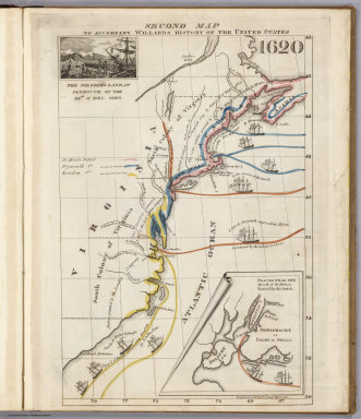
Full Title
Second Map. To Accompany Willard's History Of The United States 1620. (Inset) The Pilgrims Land at Plymouth on the 22nd. of Dec. 1620. (inset map) Places Near The Mouth of the Hudson Visited by the Dutch. Engraved & Printed by Saml. Maverick.
Publisher
White, Gallaher, & White
Author
Willard, Emma
Full Title
Third Map or Map Of 1643. To Accompany Willard's History Of The United States. (Inset) The Commencement of the Confederacy in the Union of Plymouth and Massachusetts and New Haven and Connecticut 1643. (inset map) Places Mentioned in the History of the Pequod War. Engraved & Printed by Saml. Maverick N.Y.
Publisher
White, Gallaher, & White
Author
Willard, Emma
Full Title
Fourth Map or Map Of 1692. To Accompany Willard's History Of The United States. (Inset) Massachusetts Receives a New Charter, Including Maine and Other Large Territories by the Arrival of Sir Wm. Phipps. (inset map) Places Mentioned in the History of King Philip's War. (Engraved & Printed by) Saml. Maverick & Co. N.Y.
Publisher
White, Gallaher, & White
Author
Willard, Emma
Full Title
Fifth Map or Map Of 1733. To Accompany Willard's History Of The United States. (Inset) Genl. Oglethorpe with a Colony Commence the Settlement of Georgia 1733. He meets the Indian Chief's in Council at Savannah. (Engraved & Printed by) Saml. Maverick & Co. N.Y.
Publisher
White, Gallaher, & White
Author
Willard, Emma
Full Title
Sixth Map or Map Of 1763. To Accompany Willard's History Of The United States. (Inset) The Death of Gen. Wolf Occurs at the Time of Quebec's Being Taken by the English ... that leads to the Peace of Paris 1763. (inset map) Quebec. Engraved & Printed by Saml. Maverick.
Publisher
White, Gallaher, & White
Author
Willard, Emma
Full Title
Seventh Map or Map Of 1776. To Accompany Willard's History Of The United States. (Inset) A Committee of Five draw up the Declaration of Independence. 1776. (inset map) Boston and Vicinity. (inset) (untitle map showing Lake George and surroundings). (inset) Charleston and Vicinity. Engraved & Printed by Saml. Maverick &Co. N.Y.
Publisher
White, Gallaher, & White
Author
Willard, Emma
Full Title
Eighth Map or Map Of 1789. To Accompany Willard's History Of The United States. (Inset) Federal Government Commen CD 1789. (2 untitled inset maps). (Engraved & Printed by) Saml. Maverick & Co. N.Y.
Publisher
White, Gallaher, & White
Author
Willard, Emma
Full Title
Principal Seat of the Revolutionary War in the Southern Section of the U.S. To Accompany Willard's History Of The United States. (inset map) Principal Seat of the Revolutionary War in the northern section of the U.S. Engraved & Printed by Saml. Maverick.
Publisher
White, Gallaher, & White
Author
Willard, Emma
Full Title
Ninth Map Or Map Of 1826. To Accompany Willard's History Of The United States. Referred to in the History, As the Map of the President Day. 1826. Saml. Maverick & Co. N.Y.
Publisher
White, Gallaher, & White
Author
Willard, Emma
Full Title
Principal Seat of the War of 1812-13-14. To Accompany Willard's History Of The United States. Engraved & Printed by Saml. Maverick. N.Y.
Publisher
White, Gallaher, & White
|