Who What Where WhenREMOVEWHATShow More |
Author
Stanford, Edward
Full Title
(Covers to) Stanford's Map Of The United States And Part Of The Dominion Of Canada. London: Published by Edward Stanford, 55 Charing Cross, September 1st 1875. (inset) Newfoundland, Nova Scotia, Cape Breton & Prince Edward Is.
Publisher
Edward Stanford
Author
Stanford, Edward
Full Title
Stanford's Railway & County Map Of The United States And Territories. London. Edward Stanford, 6, Charing Cross. 1861.
Publisher
Edward Stanford
Author
Stanford, Edward
Full Title
(Covers to) Stanford's Railway & County Map Of The United States And Territories. London. Edward Stanford, 6, Charing Cross. 1861.
Publisher
Edward Stanford
Author
Merriam, Moore & Co.
Full Title
(Cover to) Map of the United States and Canada. Entered ... 1853 by Daniel Burgess & Co. ... New York.
Publisher
Merriam, Moore & Co.
Author
Merriam, Moore & Co.
Full Title
(Inside Cover to) Map of the United States and Canada. Entered ... 1853 by Daniel Burgess & Co. ... New York.
Publisher
Merriam, Moore & Co.
Author
Merriam, Moore & Co.
Full Title
Map of the United States and Canada. Entered ... 1853 by Daniel Burgess & Co. ... New York.
Publisher
Merriam, Moore & Co.
Author
Colles, Christopher
Full Title
(Title Page to) A Survey of the Roads of the United States of America by Christopher Colles. 1789. C. Tiebout, Sculpt.
Publisher
C. Colles
Author
Colles, Christopher
Full Title
(Covers to) A Survey of the Roads of the United States of America by Christopher Colles. 1789. C. Tiebout, Sculpt.
Publisher
C. Colles
Author
Colles, Christopher
Full Title
(Text Page to) A Survey of the Roads of the United States of America by Christopher Colles. 1789. C. Tiebout, Sculpt.
Publisher
C. Colles
Author
[Colles, Christopher, Ristow, W. editor]
Full Title
Index to the Plates in Christopher Colles' Survey of the Roads of the United States of America. (using the) Map of the Middle States Exhibiting the Post Roads c. 1790 after Evans, Bowles and Bradley.
Publisher
Harvard Un. Press
Author
Melish, John
Full Title
United States. No. VIII. Published 1st June 1816 by J. Melish. Philadelphia. Improved to 1820. J. Melish del.
Publisher
John Melish
Author
Mitchell, Samuel Augustus
Full Title
(Covers to) Mitchell's School Atlas. Philadelphia: Thomas, Cowperthwait & Company. MDCCCXXXIX. Entered ... 1839, by S. Augustus Mitchell ... Connecticut.
Publisher
Thomas, Cowperthwait & Co.
Author
Mitchell, Samuel Augustus
Full Title
Map of the United States and Texas Engraved to Illustrate Mitchell's School and Family Geography. No. 4. (with) Map of Mexico and Guatimala ... No. 5. Engraved by W. Williams. Entered ... 1839, by S. Augustus Mitchell ... Connecticut.
Publisher
Thomas, Cowperthwait & Co.
Author
Smiley, Thomas T.
Full Title
United States. (with) Eastern States.
Publisher
Hogan & Thompson
Author
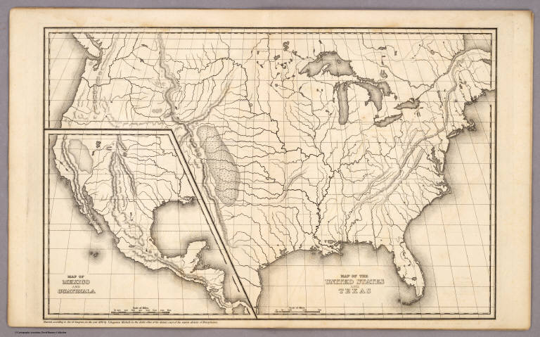
Mitchell, Samuel Augustus
Full Title
Map of the United States and Texas. (with) Map of Mexico and Guatimala. Entered ... 1839, by S. Augustus Mitchell ... Pennsylvania.
Publisher
Thomas, Cowperthwait & Co.
Author
Colton, J. H.
Full Title
(Box Cover to) J.H. Colton's Series of Dissected Maps. North America. South America. Europe. United States. Asia. Africa. In Two Sizes. (On the side of the box: United States). (Title of Map Puzzle: United States of America. Entered ... In the Year 1860 ...).
Publisher
J.H. Colton
Author
Colton, J. H.
Full Title
United States of America. Entered ... In the Year 1860 ... New York.
Publisher
J.H. Colton
Author
Colton, J. H.
Full Title
(Index Map to) United States of America. Entered ... In the Year 1860 ... New York.
Publisher
J.H. Colton
Author
Robert Sayer and John Bennett (Firm)
Full Title
(Covers to) The American Military Pocket Atlas; Being An approved Collection of Correct Maps, Both General and Particular, of The British Colonies; Especially those which now are, or probably may be The Theatre of War: Taken principally from the actual Surveys and judicious Observations of Engineers De Brahm and Romans; Cook, Jackson, and Collet; Maj. Holland, and other Officers, Employed in His Majesty's Fleets and Armies. London. Printed for R. Sayer and J. Bennet, Map and Print-Sellers (No. 53) Fleet-street.
Publisher
Sayer and Bennett
Author
Robert Sayer and John Bennett (Firm)
Full Title
(Title Page to) The American Military Pocket Atlas; Being An approved Collection of Correct Maps, Both General and Particular, of The British Colonies; Especially those which now are, or probably may be The Theatre of War: Taken principally from the actual Surveys and judicious Observations of Engineers De Brahm and Romans; Cook, Jackson, and Collet; Maj. Holland, and other Officers, Employed in His Majesty's Fleets and Armies. London. Printed for R. Sayer and J. Bennet, Map and Print-Sellers (No. 53) Fleet-street.
Publisher
Sayer and Bennett
Author
Robert Sayer and John Bennett (Firm)
Full Title
(Text Page in) The American Military Pocket Atlas; Being An approved Collection of Correct Maps, Both General and Particular, of The British Colonies; Especially those which now are, or probably may be The Theatre of War: Taken principally from the actual Surveys and judicious Observations of Engineers De Brahm and Romans; Cook, Jackson, and Collet; Maj. Holland, and other Officers, Employed in His Majesty's Fleets and Armies. London. Printed for R. Sayer and J. Bennet, Map and Print-Sellers (No. 53) Fleet-street.
Publisher
Sayer and Bennett
Author
Robert Sayer and John Bennett (Firm)
Full Title
(Index Page in) The American Military Pocket Atlas; Being An approved Collection of Correct Maps, Both General and Particular, of The British Colonies; Especially those which now are, or probably may be The Theatre of War: Taken principally from the actual Surveys and judicious Observations of Engineers De Brahm and Romans; Cook, Jackson, and Collet; Maj. Holland, and other Officers, Employed in His Majesty's Fleets and Armies. London. Printed for R. Sayer and J. Bennet, Map and Print-Sellers (No. 53) Fleet-street.
Publisher
Sayer and Bennett
Author
Anonymous
Full Title
United States.
Publisher
No Publisher
Author
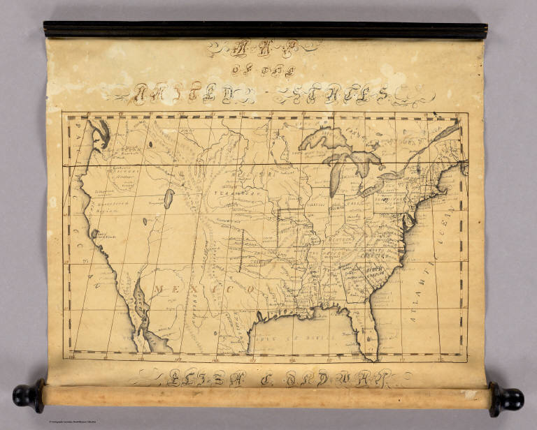
Ordway, Eliza S.
Full Title
Map Of The United States. Eliza S. Ordway.
Publisher
Manuscript
Author
Carey, Mathew
Full Title
(Covers to) Carey's American Atlas: Containing Twenty Maps And One Chart ... Philadelphia: Engraved For, And Published By, Mathew Carey, No. 118, Market Street. M.DCC.XCV. [Price, Plain, Five Dollars-Coloured, Six Dollars.]
Publisher
Mathew Carey
Author
Carey, Mathew
Full Title
(Title Page to) Carey's American Atlas: Containing Twenty Maps And One Chart ... Philadelphia: Engraved For, And Published By, Mathew Carey, No. 118, Market Street. M.DCC.XCV. [Price, Plain, Five Dollars-Coloured, Six Dollars.]
Publisher
Mathew Carey
Author
[Kimber, Emmor, Lewis, Samuel]
Full Title
(Page 1 of) Proposals by Emmor Kimber... For Publishing By Subscription, A New And Correct Map of the United States of North America. Exhibiting the counties, town, roads &c. in each state. Carefully compiled from Surveys and the most Authentic Documents. By Samuel Lewis. ... Extract from the Port-Folio, vol. 6, 1815, p. 304.
Publisher
Emmor Kimber
Author
[Kimber, Emmor, Lewis, Samuel]
Full Title
(Pages 2-3 of) Proposals by Emmor Kimber... For Publishing By Subscription, A New And Correct Map of the United States of North America. Exhibiting the counties, town, roads &c. in each state. Carefully compiled from Surveys and the most Authentic Documents. By Samuel Lewis. ... Extract from the Port-Folio, vol. 6, 1815, p. 304.
Publisher
Emmor Kimber
Author
[Kimber, Emmor, Lewis, Samuel]
Full Title
(Page 4 of) Proposals by Emmor Kimber... For Publishing By Subscription, A New And Correct Map of the United States of North America. Exhibiting the counties, town, roads &c. in each state. Carefully compiled from Surveys and the most Authentic Documents. By Samuel Lewis. ... Extract from the Port-Folio, vol. 6, 1815, p. 304.
Publisher
Emmor Kimber
Author
Colton, J. H.
Full Title
(Covers to) Map Of The United States Of America, The British Provinces, Mexico and the West Indies, Showing The Country from the Atlantic to the Pacific Ocean. Published by J.H. Colton, No. 86 Cedar St. New York. 1848. Entered ... 1846, by Joseph H. Colton ... New York. Drawn & Engraved By Sherman & Smith New-York. (inset) The south Eastern Part Of The West Indies. (inset) Map Of Newfoundland.
Publisher
J.H. Colton
Author
Colton, J. H.
Full Title
Map Of The United States Of America, The British Provinces, Mexico and the West Indies, Showing The Country from the Atlantic to the Pacific Ocean. Published by J.H. Colton, No. 86 Cedar St. New York. 1848. Entered ... 1846, by Joseph H. Colton ... New York. Drawn & Engraved By Sherman & Smith New-York. (inset) The south Eastern Part Of The West Indies. (inset) Map Of Newfoundland.
Publisher
J.H. Colton
Author
[Haskins, Charles, Lloyd, H.H., Viele, Egbert L.]
Full Title
H.H. Lloyd & Co's Campaign Military Charts Showing The Principal Strategic Places Of Interest. Engraved Expressly To Meet A Public Want During The Present War. Compiled From Official Data By Egbert L. Viele, Military and Civil Engineer; and Charles Haskins. Published Under The Auspices Of The American Geographical And Statistical Society. Entered ... 1861 by H.H. Lloyd & Co. H.H. Lloyd & Co's Military Charts. Sixteen Maps On One Sheet.
Publisher
H.H. Lloyd & Co.
Author
Lloyd, H.H.
Full Title
The National Political Chart. Lloyd's New Political Chart, 1861. With a Map of the United States, showing the Free States, Border Slave States, Cotton States, and Territories, in Different Colors. Published at H.H. Lloyd & Co.'s Agents' General Depot for Books, Maps, and Stationery Packages, 25 Howard Street, New York. Entered ... 1861, by H.H. Lloyd & Co. ... New York.
Publisher
H.H. Lloyd & Co.
Author
Prang, L. & Co.
Full Title
Map of the Atlantic States, Showing Distances From Washington (In BeeLine) By 50 Mile Circles. (The Traveling Distance is about 1/6 to 1/3 more than the BeeLine.) (with) Map of the Battle Ground (with) Map of Norfolk Harbor, Fort Monroe, and Vicinity. (with two insets) Position of Forces at Bull Run and Fortress Monroe. Published By L. Prang & Co. - No. 84 Merchants Row, Boston, Mass. Entered ... 1861 by L. Prang & Co. ... Massachusetts.
Publisher
L. Prang & Co.
Author
American Publishing Company
Full Title
Rambles Through Our Country. An Instructive Geographical Game For The Young. Copyright Secured 1881. American Publishing Company. Hartford, Conn. 1886.
Publisher
American Publishing Company
Author
[Collot, George Henri Victor, Tardieu, P.F.]
Full Title
General Map of North America. Pl. 1.
Publisher
Arthus Bertrand
Author
Tanner, Henry S.
Full Title
(Covers to) A New American Atlas Containing Maps Of The Several States of the North American Union, Projected and drawn on a Uniform Scale from Documents found in the public Offices of the United States and State Governments, and other Original and Authentic Information, By Henry S. Tanner ... Philadelphia: Published By H.S. Tanner. 1823. (title page only) Writing Drawn and Engraved by Joseph Perkins. Barralet del. Humphrys sc.
Publisher
Henry Tanner
Author
Tanner, Henry S.
Full Title
(Half Title Page to) A New American Atlas Containing Maps Of The Several States of the North American Union, Projected and drawn on a Uniform Scale from Documents found in the public Offices of the United States and State Governments, and other Original and Authentic Information, By Henry S. Tanner ... Philadelphia: Published By H.S. Tanner. 1823. (title page only) Writing Drawn and Engraved by Joseph Perkins. Barralet del. Humphrys sc.
Publisher
Henry Tanner
Author
Tanner, Henry S.
Full Title
(Title Page to) A New American Atlas Containing Maps Of The Several States of the North American Union, Projected and drawn on a Uniform Scale from Documents found in the public Offices of the United States and State Governments, and other Original and Authentic Information, By Henry S. Tanner ... Philadelphia: Published By H.S. Tanner. 1823. (title page only) Writing Drawn and Engraved by Joseph Perkins. Barralet del. Humphrys sc.
Publisher
Henry Tanner
Author
Tanner, Henry S.
Full Title
(Index Page to) A New American Atlas Containing Maps Of The Several States of the North American Union, Projected and drawn on a Uniform Scale from Documents found in the public Offices of the United States and State Governments, and other Original and Authentic Information, By Henry S. Tanner ... Philadelphia: Published By H.S. Tanner. 1823. (title page only) Writing Drawn and Engraved by Joseph Perkins. Barralet del. Humphrys sc.
Publisher
Henry Tanner
Author
Tanner, Henry S.
Full Title
(Geographical Memoir, pg. 1 in) A New American Atlas Containing Maps Of The Several States of the North American Union, Projected and drawn on a Uniform Scale from Documents found in the public Offices of the United States and State Governments, and other Original and Authentic Information, By Henry S. Tanner ... Philadelphia: Published By H.S. Tanner. 1823. (title page only) Writing Drawn and Engraved by Joseph Perkins. Barralet del. Humphrys sc.
Publisher
Henry Tanner
Author
Tanner, Henry S.
Full Title
(Geographical Memoir, pgs. 2-3 in) A New American Atlas Containing Maps Of The Several States of the North American Union, Projected and drawn on a Uniform Scale from Documents found in the public Offices of the United States and State Governments, and other Original and Authentic Information, By Henry S. Tanner ... Philadelphia: Published By H.S. Tanner. 1823. (title page only) Writing Drawn and Engraved by Joseph Perkins. Barralet del. Humphrys sc.
Publisher
Henry Tanner
Author
Tanner, Henry S.
Full Title
(Geographical Memoir, pgs. 4-5 in) A New American Atlas Containing Maps Of The Several States of the North American Union, Projected and drawn on a Uniform Scale from Documents found in the public Offices of the United States and State Governments, and other Original and Authentic Information, By Henry S. Tanner ... Philadelphia: Published By H.S. Tanner. 1823. (title page only) Writing Drawn and Engraved by Joseph Perkins. Barralet del. Humphrys sc.
Publisher
Henry Tanner
Author
Tanner, Henry S.
Full Title
(Geographical Memoir, pgs. 6-7 in) A New American Atlas Containing Maps Of The Several States of the North American Union, Projected and drawn on a Uniform Scale from Documents found in the public Offices of the United States and State Governments, and other Original and Authentic Information, By Henry S. Tanner ... Philadelphia: Published By H.S. Tanner. 1823. (title page only) Writing Drawn and Engraved by Joseph Perkins. Barralet del. Humphrys sc.
Publisher
Henry Tanner
Author
Tanner, Henry S.
Full Title
(Geographical Memoir, pgs. 8-9 in) A New American Atlas Containing Maps Of The Several States of the North American Union, Projected and drawn on a Uniform Scale from Documents found in the public Offices of the United States and State Governments, and other Original and Authentic Information, By Henry S. Tanner ... Philadelphia: Published By H.S. Tanner. 1823. (title page only) Writing Drawn and Engraved by Joseph Perkins. Barralet del. Humphrys sc.
Publisher
Henry Tanner
Author
Tanner, Henry S.
Full Title
(Geographical Memoir, pgs. 10-11 in) A New American Atlas Containing Maps Of The Several States of the North American Union, Projected and drawn on a Uniform Scale from Documents found in the public Offices of the United States and State Governments, and other Original and Authentic Information, By Henry S. Tanner ... Philadelphia: Published By H.S. Tanner. 1823. (title page only) Writing Drawn and Engraved by Joseph Perkins. Barralet del. Humphrys sc.
Publisher
Henry Tanner
Author
Tanner, Henry S.
Full Title
(Geographical Memoir, pgs. 12-13 in) A New American Atlas Containing Maps Of The Several States of the North American Union, Projected and drawn on a Uniform Scale from Documents found in the public Offices of the United States and State Governments, and other Original and Authentic Information, By Henry S. Tanner ... Philadelphia: Published By H.S. Tanner. 1823. (title page only) Writing Drawn and Engraved by Joseph Perkins. Barralet del. Humphrys sc.
Publisher
Henry Tanner
Author
Tanner, Henry S.
Full Title
(Geographical Memoir, pgs. 14-15 in) A New American Atlas Containing Maps Of The Several States of the North American Union, Projected and drawn on a Uniform Scale from Documents found in the public Offices of the United States and State Governments, and other Original and Authentic Information, By Henry S. Tanner ... Philadelphia: Published By H.S. Tanner. 1823. (title page only) Writing Drawn and Engraved by Joseph Perkins. Barralet del. Humphrys sc.
Publisher
Henry Tanner
Author
Tanner, Henry S.
Full Title
(Geographical Memoir, pgs. 16-17 in) A New American Atlas Containing Maps Of The Several States of the North American Union, Projected and drawn on a Uniform Scale from Documents found in the public Offices of the United States and State Governments, and other Original and Authentic Information, By Henry S. Tanner ... Philadelphia: Published By H.S. Tanner. 1823. (title page only) Writing Drawn and Engraved by Joseph Perkins. Barralet del. Humphrys sc.
Publisher
Henry Tanner
|