Who What Where WhenREMOVE |
Author
[Gillespie, George L., United States. War Department]
Full Title
Battle-field of Winchester, Va. September 19, 1864. Prepared by Bvt. Lt. Col. G.L. Gillespie, Major of Engineers, U.S.A. from surveys under his directions, by order of Lt. Gen. P.H. Sheridan ... 1873. George B. Strauch and E. Siegesmund, assistants. Battle-fields of Fisher's Hill and Cedar Creek, Virginia. 22 Sept. 1864, 19 Oct. 1864. Prepared by ... G.L. Gillespie ... by order of Lt. Gen. P.H. Sheridan ... 1873. George B. Strauch and E. Siegesmund, assistants. Julius Bien & Co., Lith., N.Y. (1891-1895)
Publisher
U.S. Government Printing Office
Author
United States. War Department
Full Title
Central Virginia showing Lieut. Gen. U.S. Grant's campaign and marches of the armies under his command in 1864-1865. Engineer Bureau, War Dept. (with) No. 12. Region embraced in the operations of the armies against Richmond and Petersburg, Va. Engraved at the Engineer Bureau, War Dept. Julius Bien & Co., Lith., N.Y. (1891-1895)
Publisher
U.S. Government Printing Office
Author
[Michler, Nathaniel, United States. War Department]
Full Title
Plan and section of batteries (or battery) ... on the main line of enemy's works in front of Petersburg, Va. Official: N. Michler, Major of Engineers, U.S.A. Siege of Petersburg, Va. from July 9th to July 31st, 1864 ... Official: N. Michler. Julius Bien & Co., Lith., N.Y. (1891-1895)
Publisher
U.S. Government Printing Office
Author
[McAlester, Miles D., McGregory, Samuel E., United States. War Department]
Full Title
Rebel defenses, Mobile, Ala., occupied by Union forces under Maj. Gen. E.R.S. Canby April 12, 1865. Drawn by order of Maj. McAlester, Chief Engineer, Army and Division West Miss. under direction of Lieut. S.E. McGregory ... (with) Headquarters, Army of the Potomac, Engineer Dept., June 18th, 1864. This map exhibits the lines of the enemy in our possession up to date. N. Michler. (with) Sketch of affair at Rappahannock Station, Va., March 28th 1862. (with) Position of the 3d Division, 23d Army Corps at Columbia, Tenn., Nov. 24th-29th 1864. (with) Operations from New Berne, N.C. to Kinston, of Provisional Corps under command of Maj. Gen. J.D. Cox, U.S. Army, March 1-20, 1865. (with) Sketch of the battle-field of West Harpeth River, Tenn., December 17th 1864. Bvt. Maj. Gen. James H. Wilson, comdg. (with) E. no. 1. Sketch of the main line of the enemy's works in front of Petersburg, Va., upon the advance of the United States forces, June 1864. Official: N. Michler. (with) Map accompanying the report of Maj. Gen. J.D. Cox ... of operations of the 3d Division, 23d Army Corps and other forces under his command during the operations in front of Wilmington, N.C. in February 1865. (with) Sketch showing the disposition of the Cavalry Corps, Military Division of the Miss. ... James H. Wilson, commanding, at the battle of Franklin, Tenn., November 30, 1864. By F. Tunica, Engineer ... Julius Bien & Co., Lith., N.Y. (1891-1895)
Publisher
U.S. Government Printing Office
Author
United States. War Department
Full Title
Drawings of canvas pontoon boats, bridges and chess wagons. Headquarters Detachment 50th N.Y. Vol. Engrs., Army of the Potomac. Official: J.C. Duane. Drawings of rifled projectiles used by the rebels in the Virginia Campaign of 1864. Collected near the siege batteries of the 1st Conn. Art'y. by officers and men of that regiment. Julius Bien & Co., Lith., N.Y. (1891-1895)
Publisher
U.S. Government Printing Office
Author
[McGregory, Samuel E., United States. War Department]
Full Title
Rebel lines. Mobile defenses. Fort Sidney Johnson, N, on Lieut. Col. V. Sheliha's line of works. Drawn by order of Maj. McAlester, Chief Engineer ... under direction of Lieut. S.E. McGregory ... H. Holtz, del. (with) D. No. 7. Siege of Petersburg, Va., from July 9th to July 31st 1864. Siege battery and mortar battery. Constructed under the direction of Major J.C. Duane ... by ... G.L. Gillespie. (with) D. No. 4. Siege of Petersburg, Va. ... 1864. Fort Prescott ... (with) D. No. 3. Siege of Petersburg, Va. ... 1864. Field battery ... (with) D. No. 8. Siege of Petersburg, Va. ... 1864. Field battery ... (with) Drawings of rifle projectiles used by the U.S. forces in the Virginia Campaign of 1864. (with) Rebel lines. Mobile defenses. Redan nos. 7 and 8 ... C.A. Czartoryski ... (with) Rebel lines. Mobile defenses. Battery McIntosh, water battery. C.A. Czartoryski. Julius Bien & Co., Lith., N.Y. (1891-1895)
Publisher
U.S. Government Printing Office
Author
[Hotchkiss, Jed., United States. War Department]
Full Title
Defenses of Chattanooga, Tenn. (with) Battle of Cross Keys, Va., June 8, 1862 by Jed. Hotchkiss ... Sketch showing positions of Second Corps, A.N.Va., August 26th to September 2, 1862 embracing engagements at Bristoe Station, Manassas Junction, Groveton or Second Bull Run and Ox Hill or Chantilly, Va. Prepared to accompany report of Lieut. Gen. Thos. J. Jackson by Jed. Hotchkiss ... Jan. 1863. Map of the battle-field of Chickamauga, Ga. and vicinity, fought September 18th, 19th and 20th 1863. Charles Foster, draughtsman. (with) Sketch showing position of Confederate and Federal armies at Franklin, Va., May 9th to 11th 1862 by Jed. Hotchkiss ... (with) Defenses of Cleveland, Tenn. (with) Defenses of Knoxville, Tenn. (with) Defenses of Loudon, Tenn. (with) Defenses of Charleston, Tenn. (with) Defenses of Chattanooga, Tenn. Plan of Fort Phelps. Reduced from a plan furnished by Col. W.E. Merrill ... April 18th 1865. (with) Defenses of Chattanooga, Tenn. Fort Creighton. (with) Defenses of Chattanooga, Tenn. Battery Bushnell. (with) Defenses of Chattanooga, Tenn. Lunette O'Meara. (with) Defenses of Chattanooga, Tenn. Redoubt Putnam. (with) Defenses of Chattanooga, Tenn. Fort Jones. Julius Bien & Co., Lith., N.Y. (1891-1895)
Publisher
U.S. Government Printing Office
Author
[Confederate States of America. Army of Northern Virginia, Confederate States of America. Army, Hotchkiss, Jed.]
Full Title
Route map of Gettysburg campaign. Prepared by order of Lieutenant-General T.J. Jackson, January to April 1863 by Jed. Hotchkiss, Top. Eng., 2d Corps, A.N.Va., and used during that campaign by General R.E. Lee and Lieutenant-General R.S. Ewell, C.S. Army. (with) Sketch of the battle of McDowell, Va. on Thursday May 8th 1862 (Jackson) by Jed. Hotchkiss ... (with) Sketch accompanying the report of Capt. Joseph Badger, 8th Ohio Vol. Cav. of scout through Pocahontas and Highland counties, W. Va., April 15-22, 1865. (with) Operations in N. Va., W. Va. and Md. Map of route to McDowell. Julius Bien & Co., Lith., N.Y. (1891-1895)
Publisher
U.S. Government Printing Office
Author
Colton, J.H.
Full Title
(Covers to) J.H. Colton's Topographical Map of Seat Of War In Virginia, Maryland, &c. J.H. Colton's Geographical Establishment No. 172 William St. New York. Entered.. 1855, by J.H. Colton & Co ... New York. Printed By Cooper, 117 Fulton St. N.Y.
Publisher
J.H. Colton & Co.
Author
Colton, J.H.
Full Title
J.H. Colton's Topographical Map of Seat Of War In Virginia, Maryland, &c. J.H. Colton's Geographical Establishment No. 172 William St. New York. Entered.. 1855, by J.H. Colton & Co ... New York. Printed By Cooper, 117 Fulton St. N.Y.
Publisher
J.H. Colton & Co.
Author
Colton, J.H.
Full Title
(Covers to) J.H. Colton's Topographical Map of the Seat Of War In Virginia, Maryland, &c. J.H. Colton's Geographical Establishment No. 172 William St. New York. Entered ... 1862, by J.H. Colton ... New York. Printed By Lang & Cooper, 117 Fulton St. N.Y.
Publisher
J.H. Colton & Co.
Author
Colton, J.H.
Full Title
J.H. Colton's Topographical Map of the Seat Of War In Virginia, Maryland, &c. J.H. Colton's Geographical Establishment No. 172 William St. New York. Entered ... 1862, by J.H. Colton ... New York. Printed By Lang & Cooper, 117 Fulton St. N.Y.
Publisher
J.H. Colton & Co.
Author
[Ruger, Edward, United States. War Department]
Full Title
Map prepared to exhibit the campaigns in which the Army of the Cumberland took part during the War of the Rebellion. By order of Maj. Gen. Geo. H. Thomas, U.S.A. Compiled under the direction of Bvt. Maj. Gen. Z.B. Tower, Chief Engr., Milit. Div. of the Tenn., by Ed. Ruger ... Assistants: Capt. A. Kilp and Lieut. R. Flach ... (with) Map illustrating the operations of the Seventh Division under Brig. Gen. G.W. Morgan at Cumberland Gap, Tenn., during a portion of the year 1862. Compiled by Edward Ruger ... 1877 (with) Map of the environs of Petersburg, Va., from the Appomattox River to Ft. Howard, showing the positions of the entrenched lines occupied by the Ninth Army Corps, A.P. during the siege. Julius Bien & Co., Lith., N.Y. (1891-1895)
Publisher
U.S. Government Printing Office
Author
United States. War Department
Full Title
Nashville, Tenn., from the south-east, showing the State Capitol. Accompanying letter of Col. W.E. Merrill ... (with) Fort on St. Cloud Hill, Nashville, Tenn. in course of construction, Oct. 15th '62. (with) Point of Lookout Mountain, Tenn. taken during high water, looking down the river. (with) Rossville Gap., Ga. (with) Buzzard Roost Gap and Rocky Face Ridge, Ga. (with) 100 pdr. gun battery, intrenchments at Dutch Gap, Va. (with) Canvass pontoon bridge, Appomattox River, Broadway, Va. (with) Battery Spofford, Va. (with) Signal station, Va. at Fort Wisconsin, left of line. Julius Bien & Co., Lith., N.Y. (1891-1895)
Publisher
U.S. Government Printing Office
Author
United States. War Department
Full Title
Battery Sawyer, Va. Battery Pruyn, Va. Redoubt Carpenter, Va. Redoubt Anderson, Va., No. 3. Redoubt McConihe, Va. Redoubt Dutton, Va. Redoubt Weed, Va. Redoubt Drake, Va. Castle Thunder, Richmond, Va. May, 1865. Dutch Gap Canal, as finished April, 1865. Pontoon Bridge on the James River above Jones' Landing, from the north side, 68 boats. Julius Bien & Co., Lith., N.Y. (1891-1895)
Publisher
U.S. Government Printing Office
Author
United States. War Department
Full Title
Capitol, Richmond, Va. Front view taken May 1865. Libby Prison, north side. Taken May 1865. Libby Prison, south side, taken May 1865. (with) Post Hospital, City Point, Va., 1865. Rebel Fort, now Federal No. 7 of new lines, Atlanta Ga. (with) Federal Fort No. 7, Atlanta, Ga. New line of defenses looking towards No. 8. Federal Fort No. 8, Atlanta, Ga. New line of defenses looking towards No. 7. Federal Fort No. 9, Atlanta, Ga, new line of defenses ... (with) Federal Fort No. 10, Atlanta, Ga. New line of defenses looking toward No. 9. (with) Federal Fort No. 10, Atlanta, Ga. New line of defenses, looking east ... (with) Federal Fort No. 11, Atlanta, Ga. New line of defenses, looking towards No. 10. Julius Bien & Co., Lith., N.Y. (1891-1895)
Publisher
U.S. Government Printing Office
Author
[Meigs, John R., United States. War Department]
Full Title
Map of a part of Virginia exhibiting the routes of Genl. W.W. Averell, in his three expeditions of August, November & December, 1863. Drawn under the direction of Lieut. J.R. Meigs, Corps of Engineers, Chief Engr. Dept. W. Va. (with) Map of the New Creek Sta., B.& O.R.R. Drawn by John R. Meigs ... Aug. 1863. (with) Map of Tete de Pont and battle of Big Black Bridge, May 17th, 1863. Saml. H. Lockett ... (with) Map of the battle-field of Baker's Creek, May 16th 1863. Saml. H. Lockett. Wm. L. Sheppard, draughtsman. Field works at Franklin, Tenn. Occupied by the 23rd and 4th Corps during engagements of Nov. 30th 1864. Maj. Gen. J.M. Schofield, com'd'g. Official: Wm. J. Twining ... Julius Bien & Co., Lith., N.Y. (1891-1895)
Publisher
U.S. Government Printing Office
Author
Ensign, Bridgman & Fanning
Full Title
Our Nation's Camp Ground. Published By Ensign, Bridgman & Fanning, 156 William Street, N.Y. (with) Two inset maps of the Mid-Atlantic States and Washington. (with) 6 inset pictures.
Publisher
Ensign, Bridgman & Fanning
Author
[Grant, M. B., Howell, R. H.]
Full Title
Map of the seat of war. Published by T.A. Burke, Morning News Office. Compiled & drawn by M.B. Grant C.E. Lithographed by R.H. Howell, Savannah.
Publisher
T.A. Burke
Author
United States. War Department
Full Title
Map showing the system of rebel fortifications on the Mississippi River at Island No. 10 and New Madrid, also the operations of the U.S. forces under General John Pope against these positions. (with) Route from Keetsville to Fayetteville, Ark. (with) Plan of the battle-field of Pea Ridge, Ark. Surveyed by H.A. Ulffers ... and A. Hoeppner ... (with) Route followed by the command of Maj. Joseph Conrad ... from near Bentonville, Ark. to Cassville, Mo., March 4-7, 1862. (with) Sketch A. Battle-field of Pea Ridge, Ark, March 7th, 1862 accompanying Report of Capt. Louis Hoffmann ... (with) Sketch B. Battle-field of Pea Ridge, Ark, March 8th, 1862 ... (with) Rebel position at Centreville, reconnaissance of March 14th, 1862 by M.D. McAlester ... (with) Battle at Leetown, March 7th, 1862. (with) Manassas Junction and vicinity surveyed by party of U.S. Coast Survey ... to act under orders of Lt. Col. J.N. Macomb ... Field work under direction of H.L. Whiting ... April 1862. (with) Sketch of battle-field at Shiloh near Pittsburg Landing, Tenn., April 6 and 7, 1862. Julius Bien & Co., Lith., N.Y. (1891-1895)
Publisher
U.S. Government Printing Office
Author
United States. War Department
Full Title
Map of the Rappahannock River from Port Royal to Richards Ferry. Drawn from surveys made by officers of the Engineer Brigade and charts of the Coast Survey of the river below Fredericksburg, under direction of Brig. Gen. D.P. Woodbury. Map of the field-operations of the Army of the Potomac under Major General Joseph Hooker in the battles with the army of General Lee near Chancellorsville and Fredericksburg between April 27th and May 7th, 1863 ... by Brig. Gen. G.K. Warren, Capt. Engineers ... (with) Engineer Office, Hd. Qrs. Expeditionary Corps, July 15th, 1863. Map illustrating the operations of the U.S. forces against Jackson, Miss. Compiled from the survey of Capt. Pitzman, May 14th-16th and from the surveys ... since July 10th. (with) Portions of the Middle Department, 2nd Division, 8th Army Corps. Prepared by Capt. W. Angelo Powell ... Winchester, June, 1863. Julius Bien & Co., Lith., N.Y. (1891-1895)
Publisher
U.S. Government Printing Office
Author
Magnus, Charles
Full Title
One Hundred & Fifty Miles Around Richmond. Charles Magnus' New York Printing Establishment - Offices: 12 Frankfort St., New York, and 520 7th St. Washington, D.C. Eleventh Edition 3000 of Magnus' all around Map ... Battle Ground of the Wilderness and Spottsylvania Court House. May, 5-23, 1864. Price 50 Cents. (with 9 small maps) Memphis And Nashville, Tenn. 225 Miles Around Vicksburg, Miss. 250 Miles Around Galveston, Texas. 200 Miles Around Montgomery, Ala. 100 Miles Around Milledgeville, Ga. Fortifications Around Richmond, Va. 250 Miles Around Charleston, S.C. 100 Miles Around Chattanooga, Tenn. Knoxville, Tenn., Danville, Ky. And Parkersburg, Va.
Publisher
Charles Magnus
Author
[Kayser, G., Worret, Charles]
Full Title
Military Map of a part of Eastn. Virginia Department of Maj: Genl: J.A. Dix Comdg 7th Army Corps completed from several Military Reconnaissances & Surveys under the Direction of Capt: Wm. Heine Topt. Engr. U.S. drawn & compiled by Lieut. Ch. Worret & G. Kayser Traced by Lieut. Ch. Worret.
Publisher
No Publisher
Author
Bachmann, John
Full Title
(Covers to) Panorama of the Seat of War. Birds Eye View Of Virginia, Maryland Delaware And The District Of Columbia. John Bachmann, Publisher, 115 & 117 Nassau St., New York. Entered ... 1861 by John Bachmann ... New York. Drawn from Nature and Lith. by John Bachmann.
Publisher
John Bachmann
Author
Bachmann, John
Full Title
Panorama of the Seat of War. Birds Eye View Of Virginia, Maryland Delaware And The District Of Columbia. John Bachmann, Publisher, 115 & 117 Nassau St., New York. Entered ... 1861 by John Bachmann ... New York. Drawn from Nature and Lith. by John Bachmann.
Publisher
John Bachmann
Author
Mallory, C.A.
Full Title
(Cover to) Part of the North Bank of the Rappahannock River showing the approaches to Fredericksburg, prepared under the direction of Capt. R.S. Williamson & 1st Lt. Nicholas Bowen ... for the use of the Army of the Potomac compiled by Fred. Churchill Vol. A.D.C. U.S. Coast Survey Chart of the Rappahannock River Surveys and Reconnoissances by C.A. Mallory, Chas. Shoemacker, L.C. Oswell, H.H. Marvin, Geo. F. Lathrop, Assistants. Drawn by C.A. Mallory. Reduced and photographed by L.E. Walker, Treasy. Dept.
Publisher
U.S. Treasury Dept.
Author
Mallory, C.A.
Full Title
Part of the North Bank of the Rappahannock River showing the approaches to Fredericksburg, prepared under the direction of Capt. R.S. Williamson & 1st Lt. Nicholas Bowen ... for the use of the Army of the Potomac compiled by Fred. Churchill Vol. A.D.C. U.S. Coast Survey Chart of the Rappahannock River Surveys and Reconnoissances by C.A. Mallory, Chas. Shoemacker, L.C. Oswell, H.H. Marvin, Geo. F. Lathrop, Assistants. Drawn by C.A. Mallory. Reduced and photographed by L.E. Walker, Treasy. Dept.
Publisher
U.S. Treasury Dept.
Author
[Hall, E.S., Lloyd, H.H., Waters & Son]
Full Title
Military Portraits. Glossary Of War Terms, Maps, Arms, Etc. (Map of) Maryland, Virginia, Chesapeake Bay, Etc., Etc. Published by H.H. Lloyd & Co., 25 Howard Street, New York. Agents wanted to sell this and many other Charts for the times. Entered ... 1861, by H.H. Lloyd & Co.
Publisher
H.H. Lloyd & Co.
Author
Hughes, W.C. Major
Full Title
Hughes Military Map Of Richmond & Petersburgh, Va. Showing the Rebel Fortifications drawn on the ground for the War Department by Major W.C. Hughes of Michigan. Published by Philip & Solomons, Washn. D.C. Print by J.F. Gedney, Washn. Willenbucher, Lith. Respectfully dedicated to the Army of the Potomac.
Publisher
Philip & Solomons
Author
Prang, L. & Co.
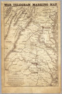
Full Title
War Telegram Marking Map. L. Prang & Co. Print Publishers, 159, Washington St. Boston ... Entered ... 1862 by L. Prang & Co. ... Massachusetts.
Publisher
L. Prang
Author
[Hall, E.S., New York Herald]
Full Title
Important Operations in Kentucky and Tennessee. The Battle Ground of Gen. Nelson at Piketon--The Brilliant Victory Over the Rebels--Situation of the Bridges Destroyed by the Unionists of Tennessee--The Cumberland Gap--Positions of the Contending Armies, &c., &c., &c. New York Herald War Maps and Diagrams. (Pages) 4 and 5.
Publisher
New York Herald
Author
[Hall, E.S., New York Herald]
Full Title
Seven maps from the New York Herald War Maps and Diagrams. (Pages) 3 and 6. (see note field for titles).
Publisher
New York Herald
Author
[Hall, E.S., New York Herald]
Full Title
Map of New Orleans and Surrounding Country. (with) The Lower Potomac. New York Herald War Maps and Diagrams. (Page) 8.
Publisher
New York Herald
Author
Abbot, Henry L.
Full Title
Official Plan of The Siege Of Yorktown Va. Conducted by the Army of the Potomac under the command of Maj. Gen. George B. McClellan U.S.A. April 5th to May 3rd 1862. Prepared under the direction of Brig. Gen J.G. Barnard Chief Engr. by Lieut. Henry L. Abbot Top. Engrs. A.D.C. ... Lith. by J.F. Gedney, Washn. Chas. G. Krebs, Engr.
Publisher
J.F. Gedney
Author
Abbot, Henry L.
Full Title
Campaign Map, Army Of The Potomac. Map No. 3 White House To Harrisons Landing. Prepared By Command Of Maj. Gen. George B. McClellan, U.S.A. Commanding Army Of The Potomac Brig. Gen. A.A. Humphreys ... Compilation under the Direction of Brig. Gen. A.A. Humphreys, By Capt. H.L. Abbot, Top. Engrs. Engraved by W.H. Dougal.
Publisher
U.S.
Author
Abbot, Henry L.
Full Title
Campaign Map, Army Of The Potomac. Map No. 2 Williamsburg To White House. Prepared By Command Of Maj. Gen. George B. McClellan, U.S.A. Commanding Army Of The Potomac Brig. Gen. A.A. Humphreys ... Compilation under the Direction of Brig. Gen. A.A. Humphreys, By Capt. H.L. Abbot, Top. Engrs. Engraved by W.H. Dougal.
Publisher
U.S.
Author
Abbot, Henry L.
Full Title
Campaign Maps, Army Of The Potomac. Map No. 1 Yorktown To Williamsburg. Prepared By Command Of Maj. Gen. George B. McClellan U.S.A. Commanding Army Of The Potomac Brig. Gen. A.A. Humphreys ... Compilation under the Direction of Brig. Gen. A.A. Humphreys, By Capt. H.L. Abbot, Top. Engrs. Engraved by W.H. Dougal.
Publisher
U.S.
Author
Monk, Jacob
Full Title
(Covers to) Map Of The Seat Of War Exhibiting The Surrounding Country, The Approaches By Sea & Land To The Capital Of The United States And The Military Posts, Forts, &c. Published by Jacob Monk, Philadelphia. 1861. T. Sinclair's Lith, Phila.
Publisher
Jacob Monk
Author
Monk, Jacob
Full Title
Map Of The Seat Of War Exhibiting The Surrounding Country, The Approaches By Sea & Land To The Capital Of The United States And The Military Posts, Forts, &c. Published by Jacob Monk, Philadelphia. 1861. T. Sinclair's Lith, Phila.
Publisher
Jacob Monk
Author
Johnson, A.J.
Full Title
Johnson's Map of the Vicinity of Richmond, and Peninsular Campaign in Virginia (American Civil War) ... By Johnson and Ward.
Publisher
Johnson and Ward
Author
Lloyd, J. T.
Full Title
(Covers to) Lloyd's official map of the State of Virginia from actual surveys by order of the Executive 1828 & 1859. Corrected and revised by J.T. Lloyd to 1862, from surveys made by Capt. W. Angelo Powell, of the U.S. Topographical Engineers of Gen. Rosencrans' Staff. Price 25cts. ... J.T. Lloyd, Publisher, 164 Broadway, New York ... Entered ... 1861 by J.T. Lloyd ... New York.
Publisher
J.T. Lloyd
Author
Lloyd, J. T.
Full Title
Lloyd's official map of the State of Virginia from actual surveys by order of the Executive 1828 & 1859. Corrected and revised by J.T. Lloyd to 1862, from surveys made by Capt. W. Angelo Powell, of the U.S. Topographical Engineers of Gen. Rosencrans' Staff. Price 25cts. ... J.T. Lloyd, Publisher, 164 Broadway, New York ... Entered ... 1861 by J.T. Lloyd ... New York.
Publisher
J.T. Lloyd
|