Who What Where WhenREMOVEWHEREShow More |
Author
California. State Earthquake Investigation Commission
Full Title
Seismograms - sheet no. 7. Earthquake Investigation Commission. Photo lith. by A. Hoen & Co., Baltimore, Md. (Carnegie Institution of Washington. 1908)
Publisher
Carnegie Institution
Author
California. State Earthquake Investigation Commission
Full Title
Seismograms - sheet no. 8. Earthquake Investigation Commission. Photo lith. by A. Hoen & Co., Baltimore, Md. (Carnegie Institution of Washington. 1908)
Publisher
Carnegie Institution
Author
California. State Earthquake Investigation Commission
Full Title
Seismograms - sheet no. 9. Earthquake Investigation Commission. Photo lith. by A. Hoen & Co., Baltimore, Md. (Carnegie Institution of Washington. 1908)
Publisher
Carnegie Institution
Author
California. State Earthquake Investigation Commission
Full Title
Seismograms - sheet no. 10. Earthquake Investigation Commission. Photo lith. by A. Hoen & Co., Baltimore, Md. (Carnegie Institution of Washington. 1908)
Publisher
Carnegie Institution
Author
California. State Earthquake Investigation Commission
Full Title
Seismograms - sheet no. 11. Earthquake Investigation Commission. Photo lith. by A. Hoen & Co., Baltimore, Md. (Carnegie Institution of Washington. 1908)
Publisher
Carnegie Institution
Author
California. State Earthquake Investigation Commission
Full Title
Seismograms - sheet no. 12. Earthquake Investigation Commission. Photo lith. by A. Hoen & Co., Baltimore, Md. (Carnegie Institution of Washington. 1908)
Publisher
Carnegie Institution
Author
California. State Earthquake Investigation Commission
Full Title
Seismograms - sheet no. 13. Earthquake Investigation Commission. Photo lith. by A. Hoen & Co., Baltimore, Md. (Carnegie Institution of Washington. 1908)
Publisher
Carnegie Institution
Author
California. State Earthquake Investigation Commission
Full Title
Seismograms - sheet no. 14. Earthquake Investigation Commission. Photo lith. by A. Hoen & Co., Baltimore, Md. (Carnegie Institution of Washington. 1908)
Publisher
Carnegie Institution
Author
California. State Earthquake Investigation Commission
Full Title
Seismograms - sheet no. 15. Earthquake Investigation Commission. Photo lith. by A. Hoen & Co., Baltimore, Md. (Carnegie Institution of Washington. 1908)
Publisher
Carnegie Institution
Author
Wheeler, G.M.
Full Title
Parts Of N.E. California, N.W. Nevada And Southern Oregon. Atlas Sheet No. 38 B. Issued June 30th, 1882. Weyss, Rock and Karl, Del. Expeditions of 1877 & 1878 Under the Command of 1st Lieut. Geo. M. Wheeler, Corps of Engineers, U.S. Army. U.S. Geographical Surveys West Of The 100th Meridian.
Publisher
U.S.
Author
Wheeler, G.M.
Full Title
Parts Of N.E. California & N.W. Nevada, Atlas Sheet No. 38(D.). Issued Nov 15th, 1880. Herman, Franke, and Rock, Del. Expedition of 1877 Under the Command of 1st Lieut. Geo. M. Wheeler, Corps of Engineers, U.S. Army. 1st. Lieut. T.W. Symons, Corps of Engineers U.S. Army. Executive Officer & Field Astronomer. J.C. Spiller, Topographical Assistant. U.S. Geographical Surveys West Of The 100th Meridian.
Publisher
U.S.
Author
Wheeler, G.M.
Full Title
Land Classification Map Of Parts Of N.E. California & N.W. Nevada, Atlas Sheet No. 38(D.). Issued Nov 15th, 1880. Herman, Franke, and Rock, Del. Expedition of 1877 Under the Command of 1st Lieut. Geo. M. Wheeler, Corps of Engineers, U.S. Army. U.S. Geographical Surveys West Of The 100th Meridian.
Publisher
U.S.
Author
Allardt, G. F.
Full Title
Sale map no. 8 of salt marsh and tide lands situate in the county of Marin, state of California. To be sold at public auction by order of the Board of Tide Land Commissioners ... John Middleton, auctioneer. Sale to commence Tuesday, July 18th 1871 at Platt's Hall, San Francisco. B.F. Washington, Rodmond Gibbons, L.L. Bullock, Board of Tide Land Commissioners. Wm. S. Byrne, Secretary. G.F. Allardt, Chief Engineer. F.C. Hafenrichter, draughtsman. G.T. Brown & Co. Lith. 540 Clay St. S.F.
Publisher
G.T. Brown & Co. Lith.
Author
[Britton & Co., Hoadley, Milo]
Full Title
Map of the Beideman Tract lots & blocks according to official map of the Western Addition. Drawn from actual survey by M. Hoadley. ... Lith. Britton & Co. To be sold at public auction, on Saturday, Oct. 6th, 1860 at 12 o'clock M. at Platts Music Hall. By H.A. Cobb and R.H. Sinton, real estate auctrs. (with) Map of the city of San Francisco. Published by Britton & Co., Lithographers, Montgomery St. cor. of Comml. sts., San Francisco.
Publisher
Britton & Co.
Author
Lloyd, H.H.
Full Title
Atlas of the United States. California and Nevada. (by H.H. Lloyd. Published by Stedman, Brown & Lyon, Baltimore. 1873)
Publisher
Stedman, Brown & Lyon
Author
Post Publishing Company (San Francisco, Calif.)
Full Title
(Business map of San Francisco). Issued by Post Publishing Company, publishers of the Daily and Weekly Post, San Francisco, Cal. (1886?)
Publisher
Post Publishing Company
Author
Mitchell, Samuel Augustus
Full Title
Map of Oregon and Upper California. Engraved to illustrate Mitchell's school and family geography. (with) Map of the Columbia River from the Cascades to the Pacific Ocean. Entered ... 1846 by S.A. Mitchell ... Eastern District of Pennsylvania.
Publisher
Thomas, Cowperthwait & Co.
Author
Wheeler, G.M.
Full Title
Part Of North Central California. Atlas Sheet No. 47(A). Issued June 30th 1881. Weyss, Maxson & Heideman Del. Expedition of 1878, Under the Command of Capt. Geo. M. Wheeler, Corps of Engineers, U.S. Army. 1st Lieut. S.E. Tillman, Corps of Eng'rs, U.S.A. Executive Officer &c Field Astronomer. Gilbert Thompson, J.S. Polhemus. Topographical Assistants. U.S. Geographical Surveys West Of The 100th Meridian.
Publisher
U.S.
Author
Touring club italiano
Full Title
(Legend to) Stati Uniti, United States of America, California, Nevada, Utah, Arizona. Propr. Artistico-letteraria del T.C.I. Ufficio cartografico del T.C.I. (1929)
Publisher
Touring club italiano
Author
Touring club italiano
Full Title
Stati Uniti, United States of America, California, Nevada, Utah, Arizona. (with San Francisco, Oakland, Berkeley region). Propr. Artistico-letteraria del T.C.I. Ufficio cartografico del T.C.I. (1929)
Publisher
Touring club italiano
Author
Wheeler, G.M.
Full Title
Land Classification Map Of Part Of North Central California. Atlas Sheet No. 47(A). Issued June 30th 1881. Weyss, Maxson & Heideman Del. Expedition of 1878, Under the Command of Capt. Geo. M. Wheeler, Corps of Engineers, U.S. Army. U.S. Geographical Surveys West Of The 100th Meridian.
Publisher
U.S.
Author
Wheeler, G.M.
Full Title
Parts Of Eastern California And Western Nevada, Atlas Sheets 47(B) & 47(D). Issued June 30, 1879. Weyss, Lang and Herman Del. Expeditions of 1876 and 1877 Under the Command of 1st. Lieut. Geo. M. Wheeler, Corps of Engineers, U.S. Army, 1877. Executive Officers and Field Astronomers: 1st. Lieut. S.E. Tillman, Corps of Engineers U.S. Army; 2nd Lieuts. T.W. Symons, Corps of Engineers U.S. Army and M.M. Macomb, 4th Artillery U.S. Army. Topographical Assistants: Gilbert Thompson, J.C. Spiller, Anton Karl, Frank Carpenter, W.A. Cowles. U.S. Geographical Surveys West Of The 100th Meridian.
Publisher
U.S.
Author
Wheeler, G.M.
Full Title
Parts Of Eastern California And Western Nevada, Atlas Sheets 47(B) & 47(D). Expeditions of 1876 and 1877, Under the Command of 1st. Lieut. Geo. M. Wheeler, Corps of Engineers, U.S. Army. Executive Officers and Field Astronomers: 1st. Lieut. S.E. Tillman, Corps of Engineers U.S. Army; 2nd Lieuts. T.W. Symons, Corps of Engineers U.S. Army and M.M. Macomb, 4th Artillery U.S. Army. Topographical Assistants: Gilbert Thompson, J.C. Spiller, Anton Karl, Frank Carpenter, W.A. Cowles. U.S. Geographical Surveys West Of The 100th Meridian.
Publisher
U.S.
Full Title
Alpine Lake in the Sierra Nevada, near Camp Independence, Cala. 1871. U.S. Geographical Surveys West of the 100th Meridian. (1889)
Publisher
U.S.
Full Title
Kearsarge Mining Works, Kearsarge District, eastern flank of the Sierra Nevada, near Camp Independence, Cala. 1871. U.S. Geographical Surveys West of the 100th Meridian. (1889)
Publisher
U.S.
Full Title
Whitney Peak, highest of the Sierra Nevada, near head of Kern River, Cala. Called also Fisherman's Peak. 1875. U.S. Geographical Surveys West of the 100th Meridian. (1889)
Publisher
U.S.
Full Title
Horizontal sketch from Tallac Peak, Cal. Occupied Oct. 14, 1876 by Party No. 2, Cal. Section. Inst. No. 160, Wurdemann. Mountain stations. Form 1. Horizontal sketch. (U.S. Geographical Surveys West of the 100th Meridian. 1889)
Publisher
U.S.
Full Title
Horizon sketch from Tallac Peak, Cal. Occupied Oct. 14, 1876 by Part No. 2, Cal. Section. Inst. No. 160, Wurdemann. Mountain stations. Form 2. Horizon sketch. (U.S. Geographical Surveys West of the 100th Meridian. 1889)
Publisher
U.S.
Author
Wheeler, G.M.
Full Title
Topography (Truckee-Donner Pass Region, California). Julius Bien, Lith. (1889)
Publisher
U.S.
Author
Wheeler, G.M.
Full Title
Land Classification Map Of Parts Of Eastern Cal. And Western Nev., Atlas Sheets 47(B) & 47(D). Issued June 30th 1879. Weyss, Lang and Herman Del. Expeditions of 1876 and 1877 Under the Command of 1st. Lieut. Geo. M. Wheeler, Corps of Engineers, U.S. Army, 1877. U.S. Geographical Surveys West Of The 100th Meridian.
Publisher
U.S.
Full Title
Diurnal barometric curves. Horary curves Georgetown, Col. ... Colorado Springs, Col. ... Green River, Wyo. Terr. ... Los Angeles, Cal. ... Salt Lake City, Utah ... Santa Fe, New Mexico ... U.S. Geographical Surveys West of the 100th Meridian. (1877)
Publisher
U.S.
Full Title
Diurnal barometric curves. Horary curves Hughes, Col. ... Labran, Col. ... Camp Independence, Cal. ... Cottonwood Springs, Nev. ... Beaver, Utah ... U.S. Geographical Surveys West of the 100th Meridian. (1877)
Publisher
U.S.
Full Title
Diurnal temperature. Beaver, Utah. Camp Independence, Cal. Labran, Col. Hughes, Col. Cottonwood Springs, Nev. U.S. Geographical Surveys West of the 100th Meridian. (1877)
Publisher
U.S.
Full Title
Mean differences, wet and dry bulb thermometers. Beaver, Utah. Camp Independence, Cal. Labran, Col. Hughes, Col. Cottonwood Springs, Nev. U.S. Geographical Surveys West of the 100th Meridian. (1877)
Publisher
U.S.
Full Title
Diurnal force of vapor. Colorado Springs, Col. Salt Lake City, Utah. Los Angeles, Cal. Santa Fe, New Mex. Georgetown, Col. Green River, Wyo. Terr. U.S. Geographical Surveys West of the 100th Meridian. (1877)
Publisher
U.S.
Full Title
Diurnal force of vapor. Beaver, Utah. Cottonwood Springs, Nev. Hughes, Col. Labran, Col. Camp Independence, Cal. U.S. Geographical Surveys West of the 100th Meridian. (1877)
Publisher
U.S.
Author
Mitchell, Samuel Augustus
Full Title
County map of the state of California. (with) San Francisco. (with) San Francisco Bay and vicinity. Entered ... 1879 by S. Augustus Mitchell ... Washington. (1880)
Publisher
S.A. Mitchell
Full Title
County map of the state of California. (with) San Francisco. (with) San Francisco Bay and vicinity. Copyright 1886 by Wm. M. Bradley & Bro. (1890)
Publisher
John Y. Huber & Co.
Author
Allardt, G. F.
Full Title
Sale map no. 11. Salt marsh and tide lands situate in the counties of Alameda & Contra Costa, state of California. To be sold at public auction by order of the Board of Tide Land Commissioners ... Greenbaum & Co. Auctioneers. Sale to commence Wednesday July 10th 1872, at 11 A.M. at the sales rooms of Greenbaum & Co. Nos. 115 & 117 Bush Street, San Francisco. R.P. Johnson, Edgar Briggs, C.M. Stratton, Board of Tide Land Commissioners. J.M. Currier, Secretary. G.F. Allardt, Chief Engineer. Lith. Britton & Rey S.F. (inset) Tide lands in Lake Merritt.
Publisher
Britton & Rey
Author
[Galpin, S. A., United States. Census Office]
Full Title
Maps of the Pacific Coast exhibiting various subjects. Compiled from the statistics of the eight and ninth census of the United States by S.A. Galpin. (Julius Bien, Lith., 1874)
Publisher
U.S.
Author
Langley, Henry G.
Full Title
Map of San Francisco from the latest surveys. Engraved expressly for the San Francisco Directory. 1873. Lith. Britton & Rey, S.F.
Publisher
H.G. Langley
Author
[Auradou, A. L. (A. Leon), O'Shaughnessy, M. M. (Michael Maurice), 1864-1934, San Francisco (Calif.). Board of Public Works]
Full Title
Map of the city and county of San Francisco prepared by the Board of Public Works, M.M. O'Shaughnessy, City Engineer. A.L. Auradou, cartographer. Map issued October 15, 1927. Revised to Sept. 1, 1929.
Publisher
Board of Public Works
Author
[McClure, W. F. (Wilbur F.), Patterson, Smith & Co.]
Full Title
Map of Berkeley, California. W.F. McClure, City Engineer. Patterson, Smith & Co., Inc., successors to R.R. Patterson, Real Estate and Insurance, 2107 University Avenue ... General agents for Claremont Heights Tract. (1910?)
Publisher
Patterson, Smith & Co.
Author
[McClure, W. F. (Wilbur F.), Patterson, Smith & Co.]
Full Title
Claremont Heights Subdivision No. 1. Choice Berkeley villa sites. W.F. McClure, City Engineer of Berkeley. Patterson, Smith & Co., Inc., 2107 University Avenue, Berkeley, Cal. (1910?)
Publisher
Patterson, Smith & Co.
Author
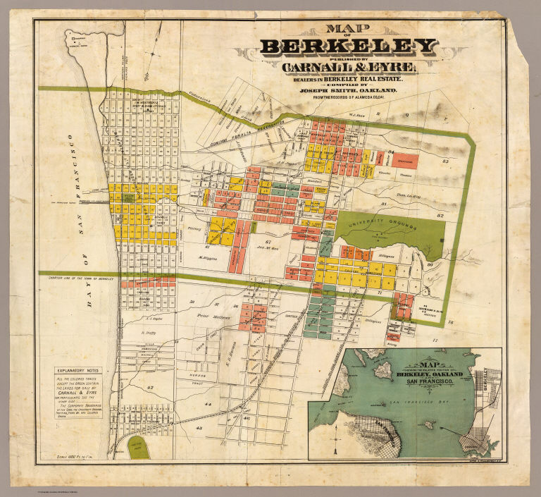
Smith, Joseph, draftsman
Full Title
Map of Berkeley. Published by Carnall & Eyre, dealers in Berkeley Real Estate. Compiled by Joseph Smith, Oakland. From the records of Alameda Co., Cal. Lith. A. Waldstein, S.F. (1880)
Publisher
Carnall & Eyre
Author
[King, M. G. (Malcolm G.), William J. Dingee]
Full Title
W.F. Melvin, E.F. Vandercook, R.D. Jackson. Jackson, Vandercook & Melvin, successors to C.W. McLaughlin & Co. Real estate and insurance agents, 458 Ninth Street. Telephone No. 285. Oakland, Cal. (1884?)
Publisher
William J. Dingee.
Author
[King, M. G. (Malcolm G.), William J. Dingee]
Full Title
Map of Oakland, Berkeley and Alameda. William J. Dingee, agent. For the purchase, sale, appraisal and care of real estate. 460 & 462 Eighth Street near Broadway, Oakland. M.G. King, C.E., surveyor. Entered ... in the year 1878, by Woodward & Taggart in the office of the Librarian of Congress at Washington, D.C. Galloway Litho Co., 418-422 Commercial St., S.F. (1884?)
Publisher
William J. Dingee.
Author
Chevalier, August
Full Title
(Covers to) The commercial, pictorial and tourist map of San Francisco. Copyrighted by Aug. Chevalier, Publisher, 331 Kearny Street. 1st edition 1904.
Publisher
Aug. Chevalier
Author
Mitchell, Samuel Augustus
Full Title
County map of the state of California. (with) San Francisco. (with) San Francisco Bay and vicinity. Entered ... 1869 by S. Augustus Mitchell, Jr. ... Pennsylvania. (1870)
Publisher
[R.A. Campbell, S.A. Mitchell, Jr.]
|