|
Author
California Department of Transportation, Division of Highways
Full Title
California Freeway and Expressway System, Planning and Construction Progress, January 1969.
Publisher
California Department of Transportation, Division of Highways
Author
California Department of Transportation, Division of Highways
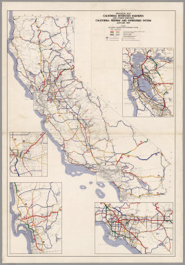
Full Title
California Freeway and Expressway System, Planning and Construction Progress, January 1971.
Publisher
California Department of Transportation, Division of Highways
Author
Irrigation Districts Association of California
Full Title
California Water Resources Development, including Development of the Bureau of Reclamation, U.S. Army Corps of Engineers, Major Features of the California Water Plan together with Various Projects of Districts and Municipalities. Issued by Irrigation Districts Association of California, Water News and Information Program.
Publisher
Irrigation Districts Association of California
Author
Irrigation Districts Association of California
Full Title
Existing and Proposed Water Developments in the State of California, 1951. Issued by Irrigation Districts Association of California, Water Economics Committee.
Publisher
Irrigation Districts Association of California
Author
[Irrigation Districts Association of California, Imagineers '68' Burton]
Full Title
California Water Resources Developments. Issued by Irrigation Districts Association of California, Water News and Information Program.
Publisher
Irrigation Districts Association of California
Author
California Department of Transportation, Division of Highways
Full Title
Progress Map, California Interstate Highways and Other Portions, California Freeway and Expressway System, May 1962.
Publisher
California Department of Transportation, Division of Highways
Author
Tanner, Henry S.
Full Title
A Map of North America, Constructed According To The Latest Information: by H.S. Tanner. S.W. Sheet.. Engraved & Published by H.S. Tanner. Philadelphia. 1822. American Atlas.
Publisher
Henry Tanner
Author
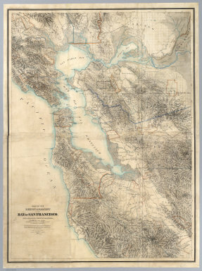
[Hoffmann, Charles F., Whitney, J.D., Geological Survey of California]
Full Title
Map Of The Region Adjacent To The Bay Of San Francisco. State Geological Survey Of California, J.D. Whitney, State Geologist. W. H. Brewer, W. M. Gabb, and A. Rémond, Assistants. C.F. Hoffman, Topographer. The Coast, Rancho, Township and Section Lines from Materials furnished by the U.S. Coast Survey and the U.S. Surveyor General's Office, the Topography chiefly from Original Surveys by C.F. Hoffman ... 1867. Engraved by Julius Bien, N.Y.
Publisher
Julius Bien
Author
[All-Year Club of Southern California, Californians Inc., Owens, Charles H.]
Full Title
(Covers to) (California Highway Map) and (Birds-Eye View of California)
Publisher
All-Year Club
Author
[All-Year Club of Southern California, Californians Inc., Owens, Charles H.]
Full Title
(California Highway Map)
Publisher
All-Year Club
Author
[All-Year Club of Southern California, Californians Inc., Owens, Charles H.]
Full Title
(Birds-Eye View of California)
Publisher
All-Year Club
Author
Bancroft, A.L.
Full Title
Bancroft's Map Of California, Nevada, Utah And Arizona. Published By A.L. Bancroft & Compy. Booksellers & Stationers, San Francisco, Cal. 1871. Entered ... by A.L. Bancroft & Company ... Washington, D.C.
Publisher
A.L. Bancroft
Author
U.S. General Land Office
Full Title
(Map 14 - California, Arizona, Nevada).
Publisher
Julius Bien
Author
U.S. General Land Office
Full Title
(Map 15 - California, Nevada, Utah, Idaho).
Publisher
Julius Bien
Author
U.S. General Land Office
Full Title
(Map 16 - Washington, Oregon, Montana, Idaho).
Publisher
Julius Bien
Author
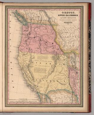
Mitchell, Samuel Augustus
Full Title
Oregon, Upper California & New Mexico. Published By S. Augustus Mitchell. N.E. corner of Market & 7th. Sts. Philadelphia. 1849. Entered ... 1845 by H.N. Burroughs ... Penna.
Publisher
S.A. Mitchell
Author
Bolitho, Edwin
Full Title
California. (to accompany) Pocket Mining Atlas. Compiled From The Latest Official Surveys, And The Most Authentic Sources. Edwin Bolitho, Engineering and Mining Journal, New York, 1880. Price, $1.00 per copy. (on following page) Entered ... 1880 ... Washington, D.C., by Trask & Francis, Bankers ... 70 Broadway, New York ...
Publisher
Edwin Bolitho, Engineering and Mining Journal
Author
Bolitho, Edwin
Full Title
Bodie District, California. (to accompany) Pocket Mining Atlas. Compiled From The Latest Official Surveys, And The Most Authentic Sources. Edwin Bolitho, Engineering and Mining Journal, New York, 1880. Price, $1.00 per copy. (on following page) Entered ... 1880 ... Washington, D.C., by Trask & Francis, Bankers ... 70 Broadway, New York ...
Publisher
Edwin Bolitho, Engineering and Mining Journal
Author
Cram, George
Full Title
Cram's Superior Map Of California Showing Distances between Railroad Stations, and Populations by Decimals of all Cities and Villages with 100 Inhabitants and over. A Concise and Ready Reference Index ... George F. Cram, Engraver and Publisher Established 1867. 130 Fulton Street, New York. 55 to 61 Market Street, Chicago. Price $3.00. Copyright, 1908, by George F. Cram, Chicago ... Geo. F. Cram, Engraver, Chicago. (inset) Vicinity Of San Francisco, Oakland, Sacramento, San Jose, Stockton. George F. Cram, Engr. & Pub. Chicago, Ill. (with 3 additional inset maps).
Publisher
George F. Cram
Author
Railroad Commission of the State of California
Full Title
1926 Edition Of The Official Railroad Map Of California. Issued by Railroad Commission Of The State Of California. State Building, San Francisco ... Compiled by the Railroad Commission of the State of California, Engineering Department, Lester S. Ready, Chief Engineer. J.W. Clement Co., Buffalo, N.Y. (with 4 inset maps).
Publisher
J.W. Clement
Author
U.S. General Land Office
Full Title
Department Of The Interior General Land Office J.A. Williamson, Commissioner. State Of California. 1876. Compiled from the official Records of the General Land Office and other sources by C. Roeser, Principal Draughtsman G.L.O. Photo lith & print by Julius Bien 16 & 18 Park Place N.Y.
Publisher
Julius Bien
Author
Britton & Rey
Full Title
Map showing the Golden Gate Park, The Avenue And Buena Vista Park. 1903. Lith. Britton & Rey, S.F.
Publisher
Britton & Rey
Author
Fairbanks, Harold W.
Full Title
Natural Environment Physical Political Map California.
Publisher
A.J. Nystrom & Co.
Author
Bagley, H.N.
Full Title
Culture Areas of the Indians of California, Showing also the tribes or local divisions.
Publisher
Bagley
Author
[State of California: The Resources Agency, Department of Water Resources]
Full Title
Surface Water Resources Development in California.
Publisher
California Department of Water Resources
Author
Jackson, William A.
Full Title
Map Of The Mining District of California by Wm. A. Jackson. Published by Lambert & Lane, 69 Wall St. New York. Entered ... 1851 by Lambert & Lane ... New York. (with 16 page appendix) Appendix To Jackson's Map Of The Mining Districts Of California. ... Second Edition, Revised And Enlarged. New-York: Lambert & Lane, 69 Wall-Street. 1851.
Publisher
Lambert & Lane
Author
Mitchell, Samuel Augustus Jr.
Full Title
County map of California. (with two insets) 46. Map of the Settlements in the Great Salt Lake, Utah. 47. San Francisco and Vicinity. Entered ... 1860 by S. Augustus Mitchell, Jr. ... Pennsylvania.
Publisher
S.A. Mitchell Jr.
Author
Vancouver, George, 1757-1798
Full Title
A Chart shewing part of the Coast of N.W. America, With the Tracks of His Majesty's Sloop Discovery and Armed Tender Chatham; Commanded by George Vancouver Esqr. and prepared under his immediate inspection by Lieut. Joseph Baker, in which the Continental Shore has been traced and determined from Lat. 30¼00'N. and Long. 244¼32' E. to Lat. 38¼30'N and Long 237¼13'E. Engraved by T. Foot, Weston Place, Battle Bridge. No. 8. (with) Entrance of Port Sn. Francisco. (and) Port Sn. Diego. London: Published May 1st 1798, by J. Edwards Pall Mall & G. Robinson Paternoster Row.
Publisher
G.G. & J. Robinson
Author
Vancouver, George, 1757-1798
Full Title
Views of Parts of the Coast of North West America. 9. W. Alexander delt. from Sketches made on the spot. London: Published May 1st 1798, by R. Edwards New Bond Street, J. Edwards Pall Mall and G. Robinson Paternoster Row. J. Fittler sculp.
Publisher
G.G. & J. Robinson
Author
Colton, J.H.
Full Title
(Covers to) Colton's California 1861. Published By J.H. Colton, 172 William St. New York. York. Entered ... 1855 by J.H. Colton ... New York. (inset) City Of San Francisco.
Publisher
J.H. Colton
Author
Colton, J.H.
Full Title
Colton's California 1861. Published By J.H. Colton, 172 William St. New York. York. Entered ... 1855 by J.H. Colton ... New York. (inset) City Of San Francisco.
Publisher
J.H. Colton
Author
[Langley, Henry G., Wackenreuder, V.]
Full Title
City And County Of San Francisco. Compiled From Official Surveys And Sectionalized In Accordance With U.S. Surveys. Drawn By V. Wackenreuder, C.E. 1861. Published By Henry G. Langley For the San Francisco Directory. Entered ... 1861 By Henry G. Langley ... California. Britton & Co. Print. (with 3 inset maps of the Farrallon Islands).
Publisher
Henry Langley
Full Title
Court House, Jail, Fresno County, Cala. (Compiled, drawn and published from personal examinations and surveys by Thos. H. Thompson, Tulare, California, 1891)
Publisher
Thompson Thos. H.
Author
Thompson, Thos. H.
Full Title
Map of the state of California, compiled expressly for Thos. H. Thompson, publisher, Tulare, Cal. Issued with the Fresno County atlas. Lith. Britton & Rey, S.F. (1891)
Publisher
Thompson Thos. H.
Author
Ritchie, A. H.
Full Title
M.J. Church. Engd. by A.H. Ritchie. (1891)
Publisher
Thompson Thos. H.
Author
Thompson, Thos. H.
Full Title
Map of Fresno County, California 1891. Published by Thos. H. Thompson, Tulare, Cal.
Publisher
Thompson Thos. H.
Full Title
Fancher Creek Nursery, Fresno County. F. Roeding, proprietor, G.C. Roeding, manager, Fresno, Cal. (Compiled, drawn and published from personal examinations and surveys by Thos. H. Thompson, Tulare, California, 1891)
Publisher
Thompson Thos. H.
Author
[Thomas Bros., Freese, Harry]
Full Title
Commercial and school map of California ; Compiled, published and copyrighted by Harry Freese ; published and for sale by Thomas Bros. (insets) San Francisco, Oakland and vicinity. Scale 1:335,000 ; Los Angeles and vicinity. Scale 1:335,000 ; Map showing township range survey system in California.
Publisher
Thomas Bros.
Full Title
Range 21 East ... Range 24 East, Township 2 South ... Township 4 South. (Compiled, drawn and published ... by Thos. H. Thompson, Tulare, California, 1891)
Publisher
Thompson Thos. H.
Full Title
Range 20 East, Range 21 East, Township 6 South. (with) Nevada Colony, sections 31, 32 & 33., Tp. 13 S., R. 21 E., Fresno County, Cala. (Compiled, drawn and published ... by Thos. H. Thompson, Tulare, California, 1891)
Publisher
Thompson Thos. H.
Full Title
Las Palmas Vineyard, Benj. R. Woodworth, proprietor, Fresno, Cal. (Compiled, drawn and published from personal examinations and surveys by Thos. H. Thompson, Tulare, California, 1891)
Publisher
Thompson Thos. H.
Full Title
Range 22 East, Range 23 East, Township 5 South, Township 6 South. (Compiled, drawn and published ... by Thos. H. Thompson, Tulare, California, 1891)
Publisher
Thompson Thos. H.
Full Title
Range 18 East, Range 19 East, Township 8 South, Township 7 South. (with) Map of Raymond ... (with) Mines located on sections 25 & 36, Tp. 9 R. 22 E., Fresno Co., Cala. (Compiled, drawn and published ... by Thos. H. Thompson, Tulare, California, 1891)
Publisher
Thompson Thos. H.
Author
Edward Denny & Co.
Full Title
Denny's pocket map of San Benito County, California : compiled from latest official and private data. By Edward Denny & Co. Map publishers, 338 Bush Street, San Francisco. Copyright 1913 by Edward Denny & Co. Revised, January 1st., 1920.
Publisher
Edward Denny & Co.
Full Title
Range 20 East, Range 21 East, Township 8 South, Township 7 South. (Compiled, drawn and published ... by Thos. H. Thompson, Tulare, California, 1891)
Publisher
Thompson Thos. H.
Full Title
Range 22 East, Range 23 East, Township 8 South, Township 7 South. (Compiled, drawn and published ... by Thos. H. Thompson, Tulare, California, 1891)
Publisher
Thompson Thos. H.
Full Title
Range 24 East ... Range 27 East, Township 8 South ... Township 5 South. (Compiled, drawn and published ... by Thos. H. Thompson, Tulare, California, 1891)
Publisher
Thompson Thos. H.
Full Title
Range 28 East ... Range 30 East, Township 8 South, Township 7 South. (with) Map of Covell ... (with) Map of Malaga ... (with) Map of Clifton ... (Compiled, drawn and published ... by Thos. H. Thompson, Tulare, California, 1891)
Publisher
Thompson Thos. H.
Full Title
Range 13 East, Range 14 East, Township 10 South, T.P. 9 S. (with) Fowler ... (with) Temperance Colony ... (Compiled, drawn and published ... by Thos. H. Thompson, Tulare, California, 1891)
Publisher
Thompson Thos. H.
|