Who What Where WhenREMOVEWHEREShow More |
Author
H.M. Gousha Company
Full Title
(North half) Road map of California. Prepared for Standard Oil Company of California. Scale 1 inch equals approximately 21 miles. Copyright 1956 by The H.M. Goushá Company Chicago, San Jose. Lithographed in U.S.A. (insets) Road map of United States, Map key and mileage chart, and Enlarged Map of the San Francisco District. (on verso panel title) California Points of interest and touring map. (insets) Enlarged map of the Los Angeles District, Map key and mileage chart, and California Mileage Chart.
Publisher
The H.M. Gousha Company
Author
H.M. Gousha Company
Full Title
(South half) Road map of California. Prepared for Standard Oil Company of California. Scale 1 inch equals approximately 21 miles. Copyright 1956 by The H.M. Goushá Company Chicago, San Jose. Lithographed in U.S.A. (insets) Road map of United States, Map key and mileage chart, and Enlarged Map of the San Francisco District. (on verso panel title) California Points of interest and touring map. (insets) Enlarged map of the Los Angeles District, Map key and mileage chart, and California Mileage Chart.
Publisher
The H.M. Gousha Company
Author
H.M. Gousha Company
Full Title
Road map of United States,
Publisher
The H.M. Gousha Company
Author
[H.M. Gousha Company, Tide Water Associated Oil Company]
Full Title
(Covers to) Street map of San Francisco. 1 inch = about six-tenths miles. Copyright by The H.M. Goushá Company Chicago, San Jose. Lithographed in U.S.A. ((inset) Downtown San Francisco. (onverso) San Francisco Bay Region and Adjacent Area. (prepared for) Flying A Ethyl Gasoline. Scale--one inch equals approx. 4 1/2 miles. Copyright by The H.M. Goushá Company Chicago, San Jose. Lithographed in U.S.A. by Schwabacher-Frey. (with panel title) Let's get associated, San Francisco and Bay Region. Flying "A" Service. Tide Water Associated oil Company.
Publisher
H.M. Goushá & Company
Author
[H.M. Gousha Company, Tide Water Associated Oil Company]
Full Title
Street map of San Francisco. 1 inch = about six-tenths miles. Copyright by The H.M. Goushá Company Chicago, San Jose. Lithographed in U.S.A. ((inset) Downtown San Francisco. (onverso) San Francisco Bay Region and Adjacent Area. (prepared for) Flying A Ethyl Gasoline. Scale--one inch equals approx. 4 1/2 miles. Copyright by The H.M. Goushá Company Chicago, San Jose. Lithographed in U.S.A. by Schwabacher-Frey. (with panel title) Let's get associated, San Francisco and Bay Region. Flying "A" Service. Tide Water Associated oil Company.
Publisher
H.M. Goushá & Company
Author
[H.M. Gousha Company, Tide Water Associated Oil Company]
Full Title
San Francisco Bay Region and Adjacent Area. (prepared for) Flying A Ethyl Gasoline. Scale--one inch equals approx. 4 1/2 miles. Copyright by The H.M. Goushá Company Chicago, San Jose. Lithographed in U.S.A. by Schwabacher-Frey. (with panel title) Let's get associated, San Francisco and Bay Region. Flying "A" Service. Tide Water Associated oil Company. (on verso) Street map of San Francisco. 1 inch = about six-tenths miles. Copyright by The H.M. Goushá Company Chicago, San Jose. Lithographed in U.S.A. ((inset) Downtown San Francisco.
Publisher
H.M. Goushá & Company
Author
Faust, H.W.
Full Title
(Covers to) Faust's Map Of City And County Of San Francisco California. Published By H.W. Faust. Copyrighted 1892. Galloway Litho. Co. S.F. (inset) General View Of San Francisco Bay.
Publisher
H.W. Faust
Author
Faust, H.W.
Full Title
Faust's Map Of City And County Of San Francisco California. Published By H.W. Faust. Copyrighted 1892. Galloway Litho. Co. S.F. (inset) General View Of San Francisco Bay.
Publisher
H.W. Faust
Author
Bancroft Company, The.
Full Title
(Covers to) Bancroft's Official Guide Map Of City And County Of San Francisco, Compiled From Official Maps In Surveyor's Office. Published by The Bancroft Company Booksellers, Stationers, Printers, Lithographers, etc. San Francisco, 1891. (inset) Skeleton Map Showing the relative position of San Francisco to the Surrounding Country.
Publisher
The Bancroft Co.
Author
Bancroft Company, The.
Full Title
Bancroft's Official Guide Map Of City And County Of San Francisco, Compiled From Official Maps In Surveyor's Office. Published by The Bancroft Company Booksellers, Stationers, Printers, Lithographers, etc. San Francisco, 1891. (inset) Skeleton Map Showing the relative position of San Francisco to the Surrounding Country.
Publisher
The Bancroft Co.
Author
Bancroft Company, The
Full Title
(Covers to) Bancroft's Official Guide Map Of City And County Of San Francisco, Compiled From Official Maps In Surveyor's Office. Published by The Bancroft Company Booksellers, Stationers, Printers, Lithographers, etc. San Francisco, 1887. (inset) Skeleton Map Showing the relative position of San Francisco to the Surrounding Country.
Publisher
The Bancroft Co.
Author
Bancroft Company, The
Full Title
Bancroft's Official Guide Map Of City And County Of San Francisco, Compiled From Official Maps In Surveyor's Office. Published by The Bancroft Company Booksellers, Stationers, Printers, Lithographers, etc. San Francisco, 1887. (inset) Skeleton Map Showing the relative position of San Francisco to the Surrounding Country.
Publisher
The Bancroft Co.
Author
[Doolittle, A.J., Holt, A.J., Ransom, Leander]
Full Title
(Covers to) A New Map Of The States Of California And Nevada Exhibiting the Rivers, Lakes, Bays and Islands, with the principal Towns, Roads, Railroads and Transit Routes to the Silver Mining Districts of Nevada Territory ... Carefully compiled from United States and other Reliable Surveys by Leander Ransom. And A.J. Doolittle, 1868. W. Holt, 411 Kearney St. S.F. Entered ... 1863 by Warren Holt ... California.
Publisher
Warren Holt
Author
[Doolittle, A.J., Holt, A.J., Ransom, Leander]
Full Title
A New Map Of The States Of California And Nevada Exhibiting the Rivers, Lakes, Bays and Islands, with the principal Towns, Roads, Railroads and Transit Routes to the Silver Mining Districts of Nevada Territory ... Carefully compiled from United States and other Reliable Surveys by Leander Ransom. And A.J. Doolittle, 1868. W. Holt, 411 Kearney St. S.F. Entered ... 1863 by Warren Holt ... California.
Publisher
Warren Holt
Author
Leahy, J.F.
Full Title
(Index Page to) Leahy's Hotel Guide and Railway Distance Maps. California.
Publisher
American Hotel register Co.
Author
Leahy, J.F.
Full Title
Leahy's Hotel Guide and Railway Distance Map of the State of California. Published by American Hotel Register Company. Leahy Build., 228-234 W. Ontario St., Chicago, Ill. Copyrighted by J.F. Leahy, Jan., 1934. (untitled insets of) San Francisco Bay Area, and Los Angeles and environs.
Publisher
American Hotel register Co.
Author
Leahy, J.F.
Full Title
(Index Page to) Leahy's Hotel Guide and Railway Distance Maps. California.
Publisher
American Hotel register Co.
Author
Leahy, J.F.
Full Title
Leahy's Hotel Guide and Railway Distance Map of the State of California. Published by American Hotel Register Company. Leahy Build., 228-234 W. Ontario St., Chicago, Ill. Copyrighted by J.F. Leahy, Jan., 1934. (untitled insets of) San Francisco Bay Area, and Los Angeles and environs.
Publisher
American Hotel register Co.
Author
[Gibbes, C.D., Holt, Warren]
Full Title
(Covers to) Map of the States Of California And Nevada. Carefully Compiled from the Latest Authentic Sources. By Chas. Drayton Gibbes, C.E. Comprising Information obtained from the U.S. Coast And Land Surveys ... And Others. Published by Warren Holt. No. 624 Montgomery St., San Francisco, Cal. 1875. Entered ... 1875 by Warren Holt ... Washington. S. Blinton Formerly of the U.S. Coast Survey Draughtsman & Lithographer. 148-1/2 S. Fourth Street, Philadelphia, Pa.
Publisher
Warren Holt
Author
[Gibbes, C.D., Holt, Warren]
Full Title
Map of the States Of California And Nevada. Carefully Compiled from the Latest Authentic Sources. By Chas. Drayton Gibbes, C.E. Comprising Information obtained from the U.S. Coast And Land Surveys ... And Others. Published by Warren Holt. No. 624 Montgomery St., San Francisco, Cal. 1875. Entered ... 1875 by Warren Holt ... Washington. S. Blinton Formerly of the U.S. Coast Survey Draughtsman & Lithographer. 148-1/2 S. Fourth Street, Philadelphia, Pa.
Publisher
Warren Holt
Author
[Gray, Ormando Willis, Lloyd, H.H., Walling, H. F.]
Full Title
Atlas of the United States. California and Nevada. (Published by Stedman, Brown & Lyon, Cincinnati. 1872. Entered ... 1872, by H.F. Walling, and O.W. Gray, and H.H. Lloyd & Co. ... Washington)
Publisher
Stedman, Brown & Lyon
Author
Jackson, William A.
Full Title
(Covers to) Map Of The Mining District of California by Wm. A. Jackson. Published by Lambert & Lane, 69 Wall St. New York. Entered ... 1851 by Lambert & Lane ... New York. (with 16 page appendix) Appendix To Jackson's Map Of The Mining Districts Of California. ... Second Edition, Revised And Enlarged. New-York: Lambert & Lane, 69 Wall-Street. 1851.
Publisher
Lambert & Lane
Author
Muermann, H.
Full Title
California, Nevada.
Publisher
Geo - Insttut
Author
Mitchell, Samuel Augustus
Full Title
(Covers to) A New Map of Texas Oregon and California With The Regions Adjoining. Compiled from the most recent authorities. Philadelphia Published by S. Augustus Mitchell N.E. Corner Of Market & Seventh Streets. 1846. Entered ... 1845 by H.N. Burroughs ... Pennsylvania.
Publisher
S.A. Mitchell
Author
Mitchell, Samuel Augustus
Full Title
Oregon and Upper California. Published by S. Augustus Mitchell, N.E. corner of Market & Seventh Streets. Philadelphia. 1847. Entered according to Act of Congress in the year 1845 by H.N. Burroughs in the ... District Court of the eastern district of Pennsylvania.
Publisher
S.A. Mitchell
Author
Mitchell, Samuel Augustus
Full Title
Oregon, Upper California & New Mexico. Published by S. Augustus Mitchell, N.E. corner of Market & 7th Sts. Philadelphia. 1849. Entered according to Act of Congress in the year 1845 by H.N. Burroughs in the ... District Court of the eastern district of Penna.
Publisher
S.A. Mitchell
Full Title
A new map of the state of California, the territories of Oregon & Utah, and the chief part of New Mexico. Entered according to Act of Congress in the year 1850 by Thomas, Cowperthwait & Co. in the ... District Court of the eastern district of Pennsylvania. (1852)
Publisher
Thomas, Cowperthwait & Co.
Full Title
A new map of the state of California, the territories of Oregon, Washington, Utah and New Mexico. Published by Thomas, Cowperthwait & Co., no. 253 Market Street, Philadelphia. Entered according to Act of Congress in the year 1853 by Thomas, Cowperthwait & Co. in the ... District Court of the eastern district of Pennsylvania. (1854)
Publisher
Cowperthwait, Desilver, Butler
Author
[Beckwith, Lieut., Schumann, C.]
Full Title
Valley of the Mud Lakes showing eighty two miles of the projected rail road line. June 14th at 9 A.M. from Mud Lake peak. C. Schumann from F.W. Egloffstein. Selmar Siebert's Engraving & Printing Establishment, Washington, D.C. U.S.P.R.R. Exp. & Surveys 41st Parallel. Expl. by Lieut. Beckwith. Vol. II.
Publisher
[A.O.P. Nicholson I-XI, T. Ford XII.]
Author
W. & A.K. Johnston Limited
Full Title
California (North), Nevada, Oregon (South). California (South), Nevada (South), Arizona (West).
Publisher
W. & A.K. Johnston Limited
Author
Langley, Henry G.
Full Title
(Covers to) A Map And Street Directory Of San Francisco: To Which Are Added Many Items ... Useful For Strangers Visiting The Metropolis of the Pacific. Price Seventy-Five Cents. San Francisco: Henry G. Langley, 612 Clay St. 1870. (on verso) Entered ... 1870, By Henry G. Langley ... California. (with) Map Of San Francisco From the Latest Survey. Engraved Expressly For The San Francisco Directory. 1870. Lith. Britton & Rey S.F.
Publisher
Henry G. Langley
Author
Langley, Henry G.
Full Title
(Title Page to) A Map And Street Directory Of San Francisco: To Which Are Added Many Items ... Useful For Strangers Visiting The Metropolis of the Pacific. Price Seventy-Five Cents. San Francisco: Henry G. Langley, 612 Clay St. 1870. (on verso) Entered ... 1870, By Henry G. Langley ... California. (with) Map Of San Francisco From the Latest Survey. Engraved Expressly For The San Francisco Directory. 1870. Lith. Britton & Rey S.F.
Publisher
Henry G. Langley
Author
Langley, Henry G.
Full Title
Map Of San Francisco From the Latest Survey. Engraved Expressly For The San Francisco Directory. 1870. Lith. Britton & Rey S.F. (with) A Map And Street Directory Of San Francisco: To Which Are Added Many Items ... Useful For Strangers Visiting The Metropolis of the Pacific. Price Seventy-Five Cents. San Francisco: Henry G. Langley, 612 Clay St. 1870. (on verso) Entered ... 1870, By Henry G. Langley ... California.
Publisher
Henry G. Langley
Author
Faust, H.W.
Full Title
(Covers to) Faust's Map & Guide Of San Francisco. Published by H.W. Faust. Entered by H.W. Faust ... Washington, D.C., June 1882. Galloway Litho. Co., 422 Commercial St., S.F. Compiled By P. Spitze. C.E. (inset) Map Of The City & County Of San Francisco. (inset) General View Of San Francisco Bay.
Publisher
H.W. Faust
Author
Faust, H.W.
Full Title
Faust's Map & Guide Of San Francisco. Published by H.W. Faust. Entered by H.W. Faust ... Washington, D.C., June 1882. Galloway Litho. Co., 422 Commercial St., S.F. Compiled By P. Spitze. C.E. (inset) Map Of The City & County Of San Francisco. (inset) General View Of San Francisco Bay.
Publisher
H.W. Faust
Author
Faust, H.W.
Full Title
(Text Page to) Faust's Map & Guide Of San Francisco. Published by H.W. Faust. Entered by H.W. Faust ... Washington, D.C., June 1882. Galloway Litho. Co., 422 Commercial St., S.F. Compiled By P. Spitze. C.E. (inset) Map Of The City & County Of San Francisco. (inset) General View Of San Francisco Bay.
Publisher
H.W. Faust
Full Title
A new map of the state of California, the territories of Oregon, Washington, Utah and New Mexico. Published by Charles Desilver, no. 251 Market Street, Philadelphia. Entered according to Act of Congress in the year 1856 by Charles Desilver in the ... District Court of the eastern district of Pennsylvania. (1857)
Publisher
Charles Desilver
Full Title
Map of the state of California, the territories of Oregon & Utah, and the chief part of New Mexico. Entered according to Act of Congress in the year 1851 by Thomas, Cowperthwait & Co. in the ... District Court of the eastern district of Pennsylvania.
Publisher
Thomas, Cowperthwait & Co.
Author
Faust, H.W.
Full Title
Faust's Map Of City And County Of San Francisco California. Published By H.W. Faust. Copyrighted 1894. Galloway Litho. Co. S.F. (inset) General View Of San Francisco Bay.
Publisher
H.W. Faust
Author
California Department of Transportation (CALTRANS).
Full Title
(California) State Highway Map 2005.
Publisher
California Department of Transportation (CALTRANS)
Author
California Department of Transportation (CALTRANS).
Full Title
(Verso) (California) State Highway Map 2005.
Publisher
California Department of Transportation (CALTRANS)
Author
California Department of Transportation, Division of Highways
Full Title
Progress Map, California Interstate Highways and Other Portions, California Freeway and Expressway System, January 1963.
Publisher
California Department of Transportation, Division of Highways
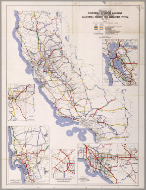
Author
California Department of Transportation, Division of Highways
Full Title
Progress Map, California Interstate Highways and Other Portions, California Freeway and Expressway System, May 1964.
Publisher
California Department of Transportation, Division of Highways
Author
California Department of Transportation, Division of Highways
Full Title
California Freeway and Expressway System, January 1965.
Publisher
California Department of Transportation, Division of Highways
Author
California Department of Transportation, Division of Highways
Full Title
State Highway Map with Freeway and Expressway System Planning and Construction Progress, January 1973.
Publisher
California Department of Transportation, Division of Highways
Author
California Department of Transportation, Division of Highways
Full Title
State Highway Map with Freeway and Expressway System Planning and Construction Progress, January 1974.
Publisher
California Department of Transportation, Division of Highways
Author
California Department of Transportation, Division of Highways
Full Title
State Highway Map with Freeway and Expressway System Planning and Construction Progress, January 1975.
Publisher
California Department of Transportation, Division of Highways
Author
California Department of Transportation, Division of Highways
Full Title
State Highway Map with Freeway and Expressway System Planning and Construction Progress, January 1968.
Publisher
California Department of Transportation, Division of Highways
Author
California Department of Transportation, Division of Highways
Full Title
State Highway Map with Freeway and Expressway System Planning and Construction Progress, January 1967.
Publisher
California Department of Transportation, Division of Highways
|