|
Author
Garcia Cubas, Antonio, 1832-1912
Full Title
(Text Page in) Atlas geografico, estadistico e historico de la Republica Mexicana, formado por Antonio Garcia y Cubas. Mexico. Imprenta de Jose Mariano Fernandez de Lara, calle de la Palma numero 4. 1858.
Publisher
Imprenta de Jose Mariano Fernandez de Lara.
Author
Garcia Cubas, Antonio, 1832-1912
Full Title
(Contents to) Atlas geografico, estadistico e historico de la Republica Mexicana, formado por Antonio Garcia y Cubas. Mexico. Imprenta de Jose Mariano Fernandez de Lara, calle de la Palma numero 4. 1858.
Publisher
Imprenta de Jose Mariano Fernandez de Lara.
Author
Garcia Cubas, Antonio, 1832-1912
Full Title
Carta general de la Republica Mexicana formada para el estudio de la configuracion y division interior de su territorio. Imp. litog. de H. Iriarte y Ca., calle de Sta Clara no. 23. J.M. Munozguren litografia. Imprenta de Lara, Entrega 16a. (Text and tables surrounding map) Cuadro geografico y estadistico de la Republica Mexicana, por Antonio Garcia y Cubas. (1858)
Publisher
Imprenta de Jose Mariano Fernandez de Lara.
Author
Garcia Cubas, Antonio, 1832-1912
Full Title
Sonora. Imp. litog. de Iriarte y Ca., ce. de Sta Clara no. 23. Munozguren litogo. Imprenta de Lara, Entrega 26a, (1858)
Publisher
Imprenta de Jose Mariano Fernandez de Lara.
Author
Garcia Cubas, Antonio, 1832-1912
Full Title
Chihuahua. Lit. de Salazar - Palma no. 4. Imprenta de Lara, (1858)
Publisher
Imprenta de Jose Mariano Fernandez de Lara.
Author
Garcia Cubas, Antonio, 1832-1912
Full Title
Coahuila. Imp. litog. de Iriarte y Ca., calle de Sta Clara no. 23. Munozguren litogo. Imprenta de Lara, Entrega 21a, (1858)
Publisher
Imprenta de Jose Mariano Fernandez de Lara.
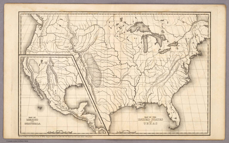
Author
Mitchell, Samuel Augustus
Full Title
Map of the United States and Texas Engraved to Illustrate Mitchell's School and Family Geography. No. 4. (with) Map of Mexico and Guatimala ... No. 5. Engraved by W. Williams. Entered ... 1839, by S. Augustus Mitchell ... Connecticut.
Publisher
Thomas, Cowperthwait & Co.
Author
Mitchell, Samuel Augustus
Full Title
Map of the United States and Texas. (with) Map of Mexico and Guatimala. Entered ... 1839, by S. Augustus Mitchell ... Pennsylvania.
Publisher
Thomas, Cowperthwait & Co.
Author
Garcia Cubas, Antonio, 1832-1912
Full Title
(Covers to) Atlas Pintoresco E Historico De Los Estados Unidos Mexicanos Por Antonio Garcia Cubas ... Publicado Por Debray Sucesores Mexico 1885.
Publisher
Debray Sucesores
Author
Garcia Cubas, Antonio, 1832-1912
Full Title
(Title Page to) Atlas Pintoresco E Historico De Los Estados Unidos Mexicanos Por Antonio Garcia Cubas ... Publicado Por Debray Sucesores Mexico 1885.
Publisher
Debray Sucesores
Author
Garcia Cubas, Antonio, 1832-1912
Full Title
Carta Politica. I. A. Garcia Cubas. Propiedad De Los Editores. Publicado por Debray Sucesores - Mexico.
Publisher
Debray Sucesores
Author
Garcia Cubas, Antonio, 1832-1912
Full Title
Carta Etnografica. II. A. Garcia Cubas. Propiedad De Los Editores. Publicado por Debray Sucesores - Mexico.
Publisher
Debray Sucesores
Author
Garcia Cubas, Antonio, 1832-1912
Full Title
Carta Eclesiastica. III. A. Garcia Cubas. Propiedad De Los Editores. Publicado por Debray Sucesores - Mexico.
Publisher
Debray Sucesores
Author
Garcia Cubas, Antonio, 1832-1912
Full Title
Vias de Comunicacion y Movimiento Maritimo. IV. A. Garcia Cubas. Propiedad De Los Editores. Publicado por Debray Sucesores - Mexico.
Publisher
Debray Sucesores
Author
Garcia Cubas, Antonio, 1832-1912
Full Title
Instruccion Publica. V. A. Garcia Cubas. Propiedad De Los Editores. Publicado por Debray Sucesores - Mexico.
Publisher
Debray Sucesores
Author
Garcia Cubas, Antonio, 1832-1912
Full Title
Carta Orografica. VI. A. Garcia Cubas. Propiedad De Los Editores. Publicado por Debray Sucesores - Mexico.
Publisher
Debray Sucesores
Author
Garcia Cubas, Antonio, 1832-1912
Full Title
Carta Hydrografica. VII. A. Garcia Cubas. Propiedad De Los Editores. Publicado por Debray Sucesores - Mexico.
Publisher
Debray Sucesores
Author
Garcia Cubas, Antonio, 1832-1912
Full Title
Carta Agricola. VIII. A. Garcia Cubas. Propiedad De Los Editores. Publicado por Debray Sucesores - Mexico.
Publisher
Debray Sucesores
Author
Garcia Cubas, Antonio, 1832-1912
Full Title
Carta Minera. IX. A. Garcia Cubas. Propiedad De Los Editores. Publicado por Debray Sucesores - Mexico.
Publisher
Debray Sucesores
Author
Garcia Cubas, Antonio, 1832-1912
Full Title
Carta Historica y Arqueologica. X. (with) Radication en Anahuac de los Nahuatlacos. A. Garcia Cubas. Propiedad De Los Editores. Publicado por Debray Sucesores - Mexico.
Publisher
Debray Sucesores
Author
Garcia Cubas, Antonio, 1832-1912
Full Title
Reyno de la Nueva Espana a Principios del Siglo XIX. XI. A. Garcia Cubas. Propiedad De Los Editores. Publicado por Debray Sucesores - Mexico.
Publisher
Debray Sucesores
Author
Garcia Cubas, Antonio, 1832-1912
Full Title
Valle De Mexico. A. Garcia Cubas. Propiedad De Los Editores. Publicado por Debray Sucesores - Mexico.
Publisher
Debray Sucesores
Author
Garcia Cubas, Antonio, 1832-1912
Full Title
Mexico y Sus Cercanias. XIII. (with) Chapultepec. A. Garcia Cubas. Propiedad De Los Editores. Publicado por Debray Sucesores - Mexico.
Publisher
Debray Sucesores
Author
Andriveau-Goujon, E.
Full Title
(Covers to) Carte Generale Des Etats - Unis Et Du Mexique Comprenant L'Amerique Centrale Et Les Antilles. E. Andriveau-Goujon, Editeur. Paris, Rue Du Bac, 21. 1865 ... (with four inset maps).
Publisher
Andriveau-Goujon
Author
Andriveau-Goujon, E.
Full Title
Carte Generale Des Etats - Unis Et Du Mexique Comprenant L'Amerique Centrale Et Les Antilles. E. Andriveau-Goujon, Editeur. Paris, Rue Du Bac, 21. 1865 ... (with four inset maps).
Publisher
Andriveau-Goujon
Author
Atwood, J.M.
Full Title
(Covers to) Map Of The United States, Canada, Mexico, Central America, and the West India Islands With a Portion of Venezuela & New Granada; Showing the routes overland and by the Isthmus to California and Oregon, Also the new Boundaries of California, Utah, & New Mexico, Compiled from the latest Authorities. Engraved & Published By J.M. Atwood, No. 19 Beekman Street, New York. 1851. D. McLellan, Printr. Spruce St ... Entered ... 1851, by J.M. Atwood ... New York.
Publisher
J.M. Atwood
Author
Atwood, J.M.
Full Title
Map Of The United States, Canada, Mexico, Central America, and the West India Islands With a Portion of Venezuela & New Granada; Showing the routes overland and by the Isthmus to California and Oregon, Also the new Boundaries of California, Utah, & New Mexico, Compiled from the latest Authorities. Engraved & Published By J.M. Atwood, No. 19 Beekman Street, New York. 1851. D. McLellan, Printr. Spruce St ... Entered ... 1851, by J.M. Atwood ... New York.
Publisher
J.M. Atwood
Author
[Bruff, J. Goldsborough, Disturnell, John]
Full Title
Map Of The Valley Of Mexico and the Surrounding Mountains. New York, Published by J.Disturnell, No. 102 Broadway, 1847. Miller's Lith. 102 Broadway, N.Y. Entered ... 1847, by John Disturnell ... New York. (inset) Map of the Route between Vera Cruz, Alvarado & Puebla. (inset) Profile Of The Route Between Mexico And Vera Cruz.
Publisher
J. Disturnell
Author
Bonne, Rigobert, 1727-1794
Full Title
Carte du Mexique ou de la Nlle. Espagne, contenant aussi le Nouveau Mexique, la Californie, avec une partie des pays adjacents. Projettee et assujettie au ciel. Par Mr. Bonne, Hydrog(raph)e du Roi. A Paris, Chez Lattre, rue St. Jaques (sic), a la Ville de Bordeaux. Avec priv. du Roi. 1771. Arrivet inv. & sculp.
Publisher
Lattre & Delalain
Author
Freyhold, Edward; Warren, Gouverneur Kemble, 1830-1882; United States. Army. Corps of Engineers
Full Title
Map of the Territory of the U.S. West of the Miss. Riv. Sheet no. 4. (Prepared by authority of the Hon. the Secretary of War in the Office of the Chief of Engineers under the direction of Brig. General A.A. Humphreys Chief of Engineers and Brevet Maj. Gen. U.S. Army. By Edward Freyhold 1879) (with) Territory of Alaska.
Publisher
U.S. Topographical Engineers
Author
Freyhold, Edward; Warren, Gouverneur Kemble, 1830-1882; United States. Army. Corps of Engineers
Full Title
Map of the Territory of the U.S. West of the Miss. Riv. Sheet no. 5. (Prepared by authority of the Hon. the Secretary of War in the Office of the Chief of Engineers under the direction of Brig. General A.A. Humphreys Chief of Engineers and Brevet Maj. Gen. U.S. Army. By Edward Freyhold 1879)
Publisher
U.S. Topographical Engineers
Author
Freyhold, Edward; Warren, Gouverneur Kemble, 1830-1882; United States. Army. Corps of Engineers
Full Title
Map of the Territory of the U.S. West of the Miss. Riv. Sheet no. 6. Prepared by authority of the Hon. the Secretary of War in the Office of the Chief of Engineers under the direction of Brig. General A.A. Humphreys Chief of Engineers and Brevet Maj. Gen. U.S. Army. By Edward Freyhold 1879.
Publisher
U.S. Topographical Engineers
Author
Tanner, Henry S.
Full Title
A map of the United States, Mexico, Central America, California, Oregon, New Mexico, W. Indies &c. With the boundaries, of the several states, railroads, canals &c. by H.S. Tanner, No. 201 Broadway, New York. 1851.
Publisher
H.S. Tanner
Author
USSR (Union of Soviet Socialist Republics).
Full Title
(Map Title Page) 212-213. Mexico. 214. Mexico, Central.
Publisher
USSR
Author
USSR (Union of Soviet Socialist Republics).
Full Title
212-213. Mexico. The World Atlas.
Publisher
USSR
Author
USSR (Union of Soviet Socialist Republics).
Full Title
214. Mexico, Central. The World Atlas.
Publisher
USSR
Author
Colton, G.W.
Full Title
Colton's Mexico. (inset) Territory and Isthmus of Tehuantepec. Published By J. H. Colton. No. 172 William St. New York.
Publisher
J. H. Colton.
Author
Colton, G.W.
Full Title
Colton's Mexico. (inset) Territory and Isthmus of Tehuantepec. Published By G. W & C. B. Colton & Co. No. 172 William St. New York.
Publisher
G. W & C. B. Colton & Co.
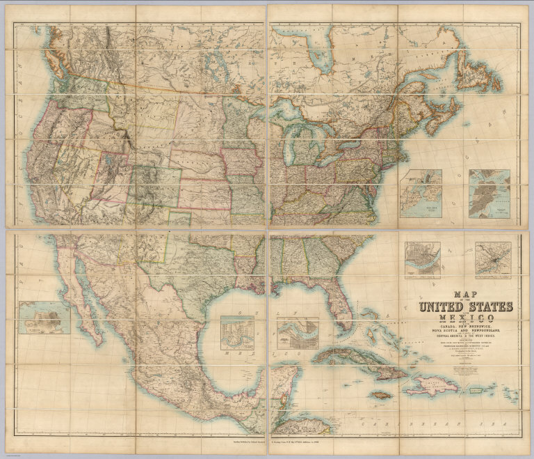
Author
[Johnston, Alexander Keith, 1804-1871, Rogers, Henry Darwin, Stanford, Edward]
Full Title
(Covers to) Map Of The United States And Mexico With Canada, New Brunswick, Nova Scotia and Newfoundland, And Parts Of Central America & The West Indies. Constructed From State Documents & Unpublished Materials By Professor H.D. Rogers of Boston U.S. and A. Keith Johnston, F.R.S.E Geographer to the Queen. London; Published by Edward Stanford, 6 Charing Cross, S.W. May 13th. 1861. Additions to 1869.
Publisher
Edward Stanford
Author
[Brue, Adrien Hubert, 1786-1832, Levasseur, E.]
Full Title
Carte Generale du Mexique, et de la partie Sud-Ouest Etats-Unis. Dresse par A. Brue, Geographe. Reoue par E. Levasseur, Membre de l'Institut, Institut Geographique de Paris. Ch. Delagrave. Editeur de la Societe de Geographie. 58 Rue des Ecoles. Carte de l'Amerique Centrale ou des Republicues de Guatemala, San Salvador, Honduras, Nicaragua, Costa Rica. Atlas Universel en 67 feuilles No. 61.
Publisher
Institut Geographique de Paris
Author
Smith, J. Calvin
Full Title
(United States, Mexico, Central America, Caribbean).
Publisher
Theodor Fischer
Author
Polish Army Topography Service
Full Title
Mexico. Pergamon World Atlas. Pergamon Press, Ltd. & P.W.N. Poland 1967. Sluzba Topograficzna W.P.
Publisher
Pergamon Press
Author
Polish Army Topography Service
Full Title
Mexico. (inset) Mexico (City). Pergamon World Atlas. Pergamon Press, Ltd. & P.W.N. Poland 1967. Sluzba Topograficzna W.P.
Publisher
Pergamon Press
Author
[Colton, J. H., Johnson, A.J.]
Full Title
Johnson's New Illustrated & Embellished County Map Of The Republics Of North America With The Adjacent Islands & Countries, Compiled Drawn & Engraved From U. States Land & Coast Surveys, British Admiralty & other Reliable Sources. Under the Direction of A.J. Johnson. Published by J.H. Colton, 172, William Street, New York, Edition For Johnson & Browning. Richmond VA. 1860. Entered ... 1860 by J.H. Colton ... New York. Map Designed by A.J. Johnson. Engraved by D.G. Johnson, J.H. Goldthwait, W.S. Barnard, Wm. Wright, G. Rae Smith, F.H. King, James Duthie, J.L. White. (inset) Map Of The World on Mercator's Projection ...
Publisher
Johnson & Browning
Author
[Butterfield, Carlos, Johnson & Browning]
Full Title
United States and Mexican Mail Steamship Line, and Statistics of Mexico. By Carlos Butterfield, Washington. December, 1859. New York: J.A.H. Hasbrouck & Co., Printers ... 1860. (on verso) Entered ... 1859, by Carlos Butterfield ... New York. (With) Map of the United States and Mexico Published by Johnson & Browning under the direction of Col. Carlos Butterfield. December 1859.
Publisher
J.A.H. Hasbrouck & Co.
Author
[Butterfield, Carlos, Johnson & Browning]
Full Title
(Title page to) United States and Mexican Mail Steamship Line, and Statistics of Mexico. By Carlos Butterfield, Washington. December, 1859. New York: J.A.H. Hasbrouck & Co., Printers ... 1860. (on verso) Entered ... 1859, by Carlos Butterfield ... New York. (With) Map of the United States and Mexico Published by Johnson & Browning under the direction of Col. Carlos Butterfield. December 1859.
Publisher
J.A.H. Hasbrouck & Co.
Author
Mitchell, Samuel Augustus
Full Title
Mitchell's New National Map Exhibiting The United States With The North American British Provinces, Sandwich Islands, Mexico And Central America, Together with Cuba and other West India Islands. Philadelphia, Published By S. Augustus Mitchell. 1858. Engraved by W. Williams, Map Engraver Philadelphia. Constructed And Engraved By W. Williams, 33 South Fifth St. Philadelphia. Entered ... 1856 by S. Augustus Mitchell ... Pennsylvania. (inset) Map Of The World On The Mercator Projection ... (inset) Map Of The World On The Globular Projection ... (inset) Map Of The Sandwich Islands.
Publisher
S. Augustus Mitchell
|