Who What Where WhenREMOVE |
Author
Page, H.R. & Co.
Full Title
Map of the World.
Publisher
H.R. Page & Co.
Author
Mitchell, Samuel Augustus
Full Title
Lengths of the Principal Rivers in the World. Heights of the Principal Mountains in the World. F. Humphrys. Sculpt.
Publisher
S.A. Mitchell
Author
Mitchell, Samuel Augustus
Full Title
A New Map of the World on the Globular Projection. Philadelphia, Published By S. Augustus Mitchell. N.E. corner of Market & 7th. Streets.
Publisher
S.A. Mitchell
Author
Hammond & Tillman Publishing Co.
Full Title
Chart of The World on Mercator's Projection. (insets) Principal Cities of the Old World. London, Paris, Berlin, St. Petersburg, Vienna, and Cairo. Statistics of the Principal Countries: Wealth of Nations, National Debts, Armies of the World, Navies of the World, Railroads of the World, Telegraphs of the World.
Publisher
Hammond & Tillman Pub. Co.
Author
Murray, J. Morrison
Full Title
Murray's Matchless Historical County, Railroad, Distance And Index Map Of The United States And Illustrated Reference Map Of The World. J. Morrison Murray, Publisher. Elizabeth, New Jersey. 1883. Copyrighted 1882. Price $4.00 ... (on verso) The Illustrated Reference Map Of The World, For Students, Business Men and Families ... Published By J.M. Murray ... (with 3 large inset maps).
Publisher
J. Morrison Murray
Author
Murray, J. Morrison
Full Title
The Illustrated Reference Map Of The World, For Students, Business Men and Families ... Published By J.M. Murray ... (with 3 large inset maps). (on verso) Murray's Matchless Historical County, Railroad, Distance And Index Map Of The United States And Illustrated Reference Map Of The World. J. Morrison Murray, Publisher. Elizabeth, New Jersey. 1883. Copyrighted 1882. Price $4.00 ...
Publisher
J. Morrison Murray
Author
[Götz, Antonín, Československá akademie věd., Czechoslovakia. Ústřední správa geodézie a kartografie.]
Full Title
Foreign Trade.
Publisher
Czechoslovakia. Ústřední správa geodézie a kartografie.
Author
Mitchell, Samuel Augustus Jr.
Full Title
(Covers to) Mitchell's New General Atlas, Containing Maps Of The Various Countries Of The World, Plans Of Cities, Etc., Embraced In Fifty-Five Quarto Maps, Forming A Series Of Eighty-Seven Maps And Plans, Together With Valuable Statistical Tables. Philadelphia: Published By S. Augustus Mitchell, Jr. No. 31 South Sixth Street. 1865. Entered ... 1860, by S. Augustus Mitchell, Jr. ... Pennsylvania.
Publisher
S.A. Mitchell Jr.
Author
Mitchell, Samuel Augustus Jr.
Full Title
(Text Page to) Mitchell's New General Atlas, Containing Maps Of The Various Countries Of The World, Plans Of Cities, Etc., Embraced In Fifty-Five Quarto Maps, Forming A Series Of Eighty-Seven Maps And Plans, Together With Valuable Statistical Tables. Philadelphia: Published By S. Augustus Mitchell, Jr. No. 31 South Sixth Street. 1865. Entered ... 1860, by S. Augustus Mitchell, Jr. ... Pennsylvania.
Publisher
S.A. Mitchell Jr.
Author
Mitchell, Samuel Augustus Jr.
Full Title
(Title Page to) Mitchell's New General Atlas, Containing Maps Of The Various Countries Of The World, Plans Of Cities, Etc., Embraced In Fifty-Five Quarto Maps, Forming A Series Of Eighty-Seven Maps And Plans, Together With Valuable Statistical Tables. Philadelphia: Published By S. Augustus Mitchell, Jr. No. 31 South Sixth Street. 1865. Entered ... 1860, by S. Augustus Mitchell, Jr. ... Pennsylvania.
Publisher
S.A. Mitchell Jr.
Author
Mitchell, Samuel Augustus Jr.
Full Title
(Contents to) Mitchell's New General Atlas, Containing Maps Of The Various Countries Of The World, Plans Of Cities, Etc., Embraced In Fifty-Five Quarto Maps, Forming A Series Of Eighty-Seven Maps And Plans, Together With Valuable Statistical Tables. Philadelphia: Published By S. Augustus Mitchell, Jr. No. 31 South Sixth Street. 1865. Entered ... 1860, by S. Augustus Mitchell, Jr. ... Pennsylvania.
Publisher
S.A. Mitchell Jr.
Author
Mitchell, Samuel Augustus Jr.
Full Title
The World in Hemispheres. With others Projections &c.&c. Constructed & Engraved by W. Williams Philadelphia. Entered ... 1860, by S. Augustus Mitchell, Jr. ... Pennsylvania. (insets) North Polar Region. The World on a Polar Projection. Land and Water Hemispheres.
Publisher
S.A. Mitchell Jr.
Author
Mitchell, Samuel Augustus Jr.
Full Title
A time table indicating the difference in time between the principal cities of the World and also showing their air-line distance from Washington. Entered ... 1864 by S. Augustus Mitchell, Jr. ... Pennsylvania.
Publisher
S.A. Mitchell Jr.
Author
Mitchell, Samuel Augustus Jr.
Full Title
Map of the World in Mercator projection. Exhibiting the American Continents as its center. Entered ... 1864 by S. Augustus Mitchell, Jr. ... Pennsylvania.
Publisher
S.A. Mitchell Jr.
Author
[Gross, Alexander, Geographia Map Company]
Full Title
The World on Mercator's Projection. Copyright "Geographia" Map Co. (Produced by)Alexander Gross, F.R.G.S. (to accompany) "Geographia", Atlas of the World : Comprising 33 pages of colored maps, 10 pages of black and white maps, and 8 pages of useful information. Produced under the direction of Alexander Gross. F.R.G.S. Fellow of the Royal Geographical, Royal Economical, Royal Statistical, royal Meteorological and royal Aeronautical Societies. Copyright 1935 by "Geographia" Map Co., 11 John St., New York.
Publisher
Geographia Map Co.
Author
Arrowsmith, Aaron Jr.
Full Title
World on Globular Projection. Arrowsmith, Hydrographer to His Majesty. Re- Published, Jany st. 1845, by G.F. Cruchley, Mapseller, 81 Fleet Street, London. (to accompany) Outlines Of The World. By A. Arrowsmith, Hydrographer to His Majesty. 1850.
Publisher
G.F. Cruchley
Author
Arrowsmith, Aaron Jr.
Full Title
World on Mercator Projection. Re- Published, Jany st. 1845, by G.F. Cruchley, Mapseller, 81 Fleet Street, London. (to accompany) Outlines Of The World. By A. Arrowsmith, Hydrographer to His Majesty. 1850.
Publisher
G.F. Cruchley
Author
Arrowsmith, Aaron Jr.
Full Title
(Text Page to) Lenghts of some of the principal rivers in the world. Hights of some of the principal mountains &c. in the world. Re- Published, Jany st. 1845, by G.F. Cruchley, Mapseller, 81 Fleet Street, London. (to accompany) Outlines Of The World. By A. Arrowsmith, Hydrographer to His Majesty. 1850.
Publisher
G.F. Cruchley
Author
[Andree, Richard, Times (London, England)]
Full Title
Constellations of the Northern Hemisphere. Constellations of the Southern Hemisphere. The Solar System. The Moon. (Published at the office of "The Times," London, 1900).
Publisher
The Office of The Times
Author
[Andree, Richard, Times (London, England)]
Full Title
Atlantic Ocean. Equatorial Scale 1:60,000,000. (Published at the office of "The Times," London, 1900).
Publisher
The Office of The Times
Author
[Andree, Richard, Times (London, England)]
Full Title
Pacific Ocean. Equatorial Scale 1:75,000,000. (Published at the office of "The Times," London, 1900).
Publisher
The Office of The Times
Author
[Andree, Richard, Times (London, England)]
Full Title
British Empire, showing the commercial routes of the World and ocean currents. (with 3 insets) Steam-ship lines of Central America & the West Indies. Steam-ship lines from ports of Western Europe. Eastern Steam-ship lines (Mediterranean and Black Seas. Published at the office of "The Times," London, 1900).
Publisher
The Office of The Times
Author
[Andree, Richard, Times (London, England)]
Full Title
Religions of the World. (with 3 insets) Distribution of Europeans. Distribution of Chinese. Distribution of Negroes. (Published at the office of "The Times," London, 1900).
Publisher
The Office of The Times
Author
[Andree, Richard, Times (London, England)]
Full Title
Isothermal and winds chart of the World. Religions of Europe. (Published at the office of "The Times," London, 1900).
Publisher
The Office of The Times
Author
Guyot, Arnold
Full Title
The World. Western Hemisphere. Eastern Hemisphere. Wall-Atlas by A. Guyot. Published by Chas. Scribner & Co. New York. The Major & Knapp Eng. Mfg. & Lith. Co. 449 Broadway, N.Y. Card Series. Entered ... 1866 by Charles Scribner & Co. ... New York.
Publisher
Scribner & Co.
Author
Mitchell, Samuel Augustus Jr.
Full Title
Map of the World on the Mercator Projection. Exhibiting the American Continent as its center. Entered ... 1874, by S. Augustus Mitchell ... Washington.
Publisher
S.A. Mitchell Jr.
Author
Johnson, A.J.
Full Title
(Covers to) Johnson's New Illustrated (Steel Plate) Family Atlas, With Descriptions, Geographical, Statistical, And Historical. Compiled, Drawn, and Engraved Under The Supervision Of J.H. Colton And A.J. Johnson. New York: Johnson And Browning, Formerly (Successors To J.H. Colton And Company,) No. 133 Nassau Street. 1860. Entered ... One Thousand Eight Hundred and Sixty, by Johnson & Browning ... Virginia.
Publisher
Johnson and Browning
Author
Johnson, A.J.
Full Title
(Half Title Page to) Johnson's New Illustrated (Steel Plate) Family Atlas, With Descriptions, Geographical, Statistical, And Historical. Compiled, Drawn, and Engraved Under The Supervision Of J.H. Colton And A.J. Johnson. New York: Johnson And Browning, Formerly (Successors To J.H. Colton And Company,) No. 133 Nassau Street. 1860. Entered ... One Thousand Eight Hundred and Sixty, by Johnson & Browning ... Virginia.
Publisher
Johnson and Browning
Author
Johnson, A.J.
Full Title
(Title Page to) Johnson's New Illustrated (Steel Plate) Family Atlas, With Descriptions, Geographical, Statistical, And Historical. Compiled, Drawn, and Engraved Under The Supervision Of J.H. Colton And A.J. Johnson. New York: Johnson And Browning, Formerly (Successors To J.H. Colton And Company,) No. 133 Nassau Street. 1860. Entered ... One Thousand Eight Hundred and Sixty, by Johnson & Browning ... Virginia.
Publisher
Johnson and Browning
Author
Johnson, A.J.
Full Title
(Index Page to) Johnson's New Illustrated (Steel Plate) Family Atlas, With Descriptions, Geographical, Statistical, And Historical. Compiled, Drawn, and Engraved Under The Supervision Of J.H. Colton And A.J. Johnson. New York: Johnson And Browning, Formerly (Successors To J.H. Colton And Company,) No. 133 Nassau Street. 1860. Entered ... One Thousand Eight Hundred and Sixty, by Johnson & Browning ... Virginia.
Publisher
Johnson and Browning
Author
Tehuantepec Railway Company
Full Title
Tehuantepec Railway Company's chart of the world on Mercator's projection showing the line of the railway, with its connections by steamships & sailing vessels with the prominent ports of the world. Compiled: Under the direction of Simon Stevens, President of the Tehuantepec Railway Co., by Col. Julius W. Adams, C.E. Photolith. by N.Y. Lithy. Engrd & Prtg. Co., 16 & 18 Park Place. Entered ... 1868, by The Tehuantepec Railway Company ... New York. (insets) Nicaragua route, the world on polar projections. (to accompany) The Tehuantepec Railway, Its Location, Features and Advantages Under the La Sere Grant of 1869. D. Appleton & Co ... 1869.
Publisher
D. Appleton & Co.
Author
Mitchell, Samuel Augustus Jr.
Full Title
Map of the World on Mercator Projection, Exhibiting the American Continent as its Centre. Entered ... 1876 by S. Augustus Mitchell, . ... Washington.
Publisher
S.A. Mitchell Jr.
Author
Delamarche, Felix
Full Title
Mappe-Monde ou Carte Generale du Globe Terrestre Dressee ... 1823.
Publisher
F. Delamarche
Author
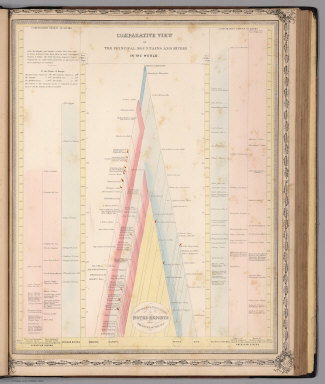
Lothian, John
Full Title
(View) Comparative View of the Principal Mountains and Rivers in the World.
Publisher
James MacLeod and Francis Orr & Sons
Author
Lothian, John
Full Title
The World.
Publisher
James MacLeod and Francis Orr & Sons
Author
[Aaron Blake Publishers, Zeleznik, John, Lewis, Susan]
Full Title
The Ian Fleming Thriller Map.
Publisher
Aaron Blake Publishers
Author
[Aaron Blake Publishers, Zeleznik, John, Lewis, Susan]
Full Title
The Ian Fleming Thriller Map.
Publisher
Aaron Blake Publishers
Author
Delamarche, Felix.
Full Title
Carte de la Geographie primitive des Grees d'apres Homere et Hesiode et des Systemes Geographiques d'Eratosthenes, d'Hipparque de Strabon, et de Ptolemee ... 1838.
Publisher
F. Delamarche
Author
Delamarche, Felix.
Full Title
Carte du Monde Connu des Anciens au Temps de Ptolemee ... 1838.
Publisher
F. Delamarche
Author
Society for the Diffusion of Useful Knowledge (Great Britain)
Full Title
The World as Known to the Ancients. Sheet I.
Publisher
Edward Stanford
Author
Society for the Diffusion of Useful Knowledge (Great Britain)
Full Title
The World as Known to the Ancients. Sheet II.
Publisher
Edward Stanford
Author
Society for the Diffusion of Useful Knowledge (Great Britain)
Full Title
(Composite) The World as Known to the Ancients.
Publisher
Edward Stanford
Author
Johnson, A.J.
Full Title
Johnson's Map Of The World on Mercator's Projection. Published by Johnson & Browning. New York & Washington. No. 56-57.
Publisher
Johnson and Browning
Author
[Raynal, G.T., Bonne, R.]
Full Title
(Text Page to) Analyse succincte de cet atlas. (to accompany) Histoire Philosophique et Politique Des Establissements et Du Commerce Des Europeens Dans Les Deux Indes.
Publisher
Jean-Leonard Pellet
Author
[Raynal, G.T., Bonne, R.]
Full Title
Planisphere general; pour servir a l'Intelligence de la navigation et du Commerce des Europeens, entr eux et dans les deux Indes. (on upper margin) Liv. I et suivans : No.2. (on lower margin) 2. (to accompany) Histoire Philosophique et Politique Des Establissements et Du Commerce Des Europeens Dans Les Deux Indes.
Publisher
Jean-Leonard Pellet
Author
[Barbie du Bocage, J.G., Dufour, H.]
Full Title
Monde Connu des Anciens.
Publisher
Maison Basset
Author
Bowen, Emanuel
Full Title
A new & accurate chart of the world. Drawn from authentic surveys, assisted by the most approved modern maps & charts & regulated by astronl. observations, whereon are described lines, shewing the variation of the magnetical needle, according to observations made by several experienced navigators about the year 1744. By Eman: Bowen, Geographer to His Majesty. (London: Printed for William Innys, Richard Ware, Aaron Ward, J. and P. Knapton, John Clarke, T. Longman and T. Shewell, Thomas Osborne, Henry Whitridge ... M.DCC.XLVII)
Publisher
William Innys [et al.]
Author
Brue, Adrien Hubert, 1786-1832
Full Title
Mappe-monde en deux Hemispheres. Carte encyprotype. Dediee & presentee a Monsieur. Par H. Brue, Geographe de S.A. Royale. A Paris, Chez Desray ... (et) Goujon ..., 1816.
Publisher
Desray, Libraire-Editeur
Author
Brue, Adrien Hubert, 1786-1832
Full Title
Mappe-monde sur la projection de Mercator. Carte encyprotype. Reduite de celle sur 4 feuilles du meme auteur. Dediee et presentee a Monsieur. Par H. Brue, Ingenieur-Geographe de S.A. Royale. A Paris, Chez Desray ... (et) Goujon ..., 1816. H. Brue dirext.
Publisher
Desray, Libraire-Editeur
|