Who What Where WhenREMOVEWHEREShow More |
Author
Rand McNally and Company
Full Title
Map of Dakota. Drawn From Official Plats Of Public Surveys, And Published In The Interest Of Immigration By The Chicago, Milwaukee & St. Paul Railway Co. Copyright, 1882, by Rand, McNally & Co., Map Publishers, Chicago, Ill. Rand, McNally & Co., Engr's Chicago ...
Publisher
Rand McNally
Author
San Francisco Board of Supervisors
Full Title
Map Of The Outside Lands Of The City And County Of San Francisco Showing Reservations Selected for Public Purposes, under the Provisions of Order No. 800 ... Litho. Britton & Rey.
Publisher
Britton & Rey
Author
San Francisco Board of Supervisors
Full Title
Map Of The Outside Lands Of The City And County Of San Francisco Showing Reservations Selected for Public Purposes, under the Provisions of Order No. 800 ... Litho. Britton & Rey.
Publisher
Britton & Rey
Author
Iowa Land Company
Full Title
Map Of The Town Of Clinton, Clinton County, Iowa. Augt. 1855. L.H. Bradford & Co's Lith Boston.
Publisher
L.H. Bradford & Co.
Author
[Colton, G.W. & C.B., Illinois Central Railroad Company]
Full Title
Railroad Map Of Illinois. One Million Acres Of Land For sale by the Illinois Central Railroad Company, all within fifteen miles of the Railroad, and extending the entire length of the state, North and South ... For further information, address, Land Commissioner, Illinois Central Railroad Company, Chicago, Ills. Entered ... 1861, by G. Woolworth Colton ... New York.
Publisher
G.W. Colton
Author
Del Monte Properties Company
Full Title
Map of Pacific Grove Properties Showing Lots which will be sold at Absolute Auction Sale. Commencing on Thursday, November 6th ... (on verso) Advertisements and views around Pacific Grove.
Publisher
No publisher
Author
Del Monte Properties Company
Full Title
(Text Page to) Map of Pacific Grove Properties Showing Lots which will be sold at Absolute Auction Sale. Commencing on Thursday, November 6th ... (on verso) Advertisements and views around Pacific Grove.
Publisher
No publisher
Author
Del Monte Properties Company
Full Title
(Text Page to) Map of Pacific Grove Properties Showing Lots which will be sold at Absolute Auction Sale. Commencing on Thursday, November 6th ... (on verso) Advertisements and views around Pacific Grove.
Publisher
No publisher
Author
Rumble, A. C.
Full Title
(Covers to) Second grand excursion to, and monster auction sale of lots and blocks in Park Place, a subdivision of the famous Laundry Farm, By Bovee, Toy & Co., on Saturday, September 8th, 1888. (to accompany) Map showing A Portion Of Park Place, Formerly Known As "Laundry Farm" Adjoining Mills Seminary On The Line Of The Alameda County Railway : Alameda County, Cal. Scale 200'=1". Surveyed July, 1888 A.C. Rumble, C.E. Lith. Britton & Rey, S.F. Shaded Lots are Sold. (map on verso) Relative Position of Park Place, Laundry Farm With Oakland & Vicinity. Britton & Rey Lith. S.F.
Publisher
Britton & Rey
Author
Rumble, A. C.
Full Title
Relative Position of Park Place, Laundry Farm With Oakland & Vicinity. Britton & Rey Lith. S.F. (on verso) Map showing A Portion Of Park Place, Formerly Known As "Laundry Farm" Adjoining Mills Seminary On The Line Of The Alameda County Railway : Alameda County, Cal. Scale 200'=1". Surveyed July, 1888 A.C. Rumble, C.E. Lith. Britton & Rey, S.F. Shaded Lots are Sold.
Publisher
Britton & Rey
Author
Rumble, A. C.
Full Title
Map showing A Portion Of Park Place, Formerly Known As "Laundry Farm" Adjoining Mills Seminary On The Line Of The Alameda County Railway : Alameda County, Cal. Scale 200'=1". Surveyed July, 1888 A.C. Rumble, C.E. Lith. Britton & Rey, S.F. Shaded Lots are Sold. (map on verso) Relative Position of Park Place, Laundry Farm With Oakland & Vicinity. Britton & Rey Lith. S.F.
Publisher
Britton & Rey
Author
Snyder & Gillis
Full Title
(Covers to) Free carriage to and from the tract. Map of the Roberts and Wolfskill Tract... To be sold at private sale at the office of Snyder & Gillis ... Cubery & Co., Electric Power Printers, S.F. (to accompany) Roberts & Wolfskill Tract. The Roberts And Wolfskill Tract, For Sale By Snyder & Gillis, 467 Ninth Street, Oakland, Cal. Cubery & co., Electric Power Printers, 415 Market St. S.F. (on verso) Location map, and (inset map) San Francisco.
Publisher
Curbey & Co.
Author
Snyder & Gillis
Full Title
(Advertisement to) ) Roberts & Wolfskill Tract. The Roberts And Wolfskill Tract, For Sale By Snyder & Gillis, 467 Ninth Street, Oakland, Cal. Cubery & co., Electric Power Printers, 415 Market St. S.F. (on verso) Location map, and (inset map) San Francisco.
Publisher
Curbey & Co.
Author
Snyder & Gillis
Full Title
Roberts & Wolfskill Tract. The Roberts And Wolfskill Tract, For Sale By Snyder & Gillis, 467 Ninth Street, Oakland, Cal. Cubery & co., Electric Power Printers, 415 Market St. S.F. (on verso) Location map, and (inset map) San Francisco.
Publisher
Curbey & Co.
Author
Snyder & Gillis
Full Title
(Untitled map of) Roberts & Wolfskill Tract. (untitled inset map) San Francisco. (on verso) Roberts & Wolfskill Tract. The Roberts And Wolfskill Tract, For Sale By Snyder & Gillis, 467 Ninth Street, Oakland, Cal. Cubery & co., Electric Power Printers, 415 Market St. S.F.
Publisher
Curbey & Co.
Author
[Anderson, Philander, Annin & Smith]
Full Title
Map Of The Town Of Ipswich, County Of Essex, State Of Massachts. Surveyed and Drawn by Philander Anderson 1832. Annin, Smith & Co.'s Lithy. (inset) Plan Of Ipswich Village.
Publisher
Annin & Smith & Co.'s Lith.
Author
[Nye, Bonum, Pendleton's Lithography]
Full Title
Map Of North-Brookfield. From Actual Survey Made By Bonum Nye In 1830. Pendleton's Lithography, Boston. North-Brookfield, (formerly the North Parish in Brookfield) was incorporated as a Town in 1812. - Population at the census in 1830 was 1241.
Publisher
Pendleton's Lithography
Author
[Brown, Wm. H. & Co., Poole Brothers]
Full Title
Map of North Dakota. Great Opportunities for Men in Farming, Stock Raising, Manufacturing and all Commercial Pursuits. 100,000 Acres in the most prosperous counties of North Dakota are offered by us on terms so easy ... Wm. H. Brown & Co.'s Lands Shown In Red. Copyrighted, 1901, by Poole Bros., Chicago.
Publisher
Poole Bros.
Author
Florida East Coast Railway
Full Title
Map of the Peninsula of Florida and Adjacent Islands. Published by the Land Department, Florida East Coast Railway. This map is absolutely correct in all the Geographical details, and every Railroad is shown in its proper location. The Matthews Northrup Co., Complete Engraving And Printing Works, Buffalo, N.Y. (inset) West Indies, Central America And South America. (inset) Bahama Islands
Publisher
Matthews-Northrup Co.
Author
Central Bluffs, Nebraska
Full Title
Central Bluffs, Burt County, Nebraska. All lots in this City are 50x150 feet, the alleys are 15 feet wide, Spring Av. is 100 feet wide, Michigan & Ohio Avenues are 80 feet & all other Streets 66 feet. Leopold Gast & Brother Lith. St. Louis, Mo. Second Carondelet Avenue betw. Lafayette & Geier Avs. S.W. from City Hospital. (Inset Map) Topographical Sketch of a Portion of Nebraska Territory.
Publisher
Leopold Gast & Brother Lith.
Author
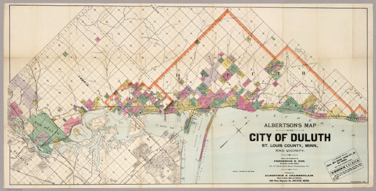
Roe, Frederick B.
Full Title
Albertson's Map Of The City Of Duluth, St. Louis County, Minn., And Vicinity. Drawn and Engraved by Frederick B. Roe, Civil Engineer and Map Publisher, No. 17 North Sixth Street, Philadelphia, Pa. Published by Albertson & Chamberlain ... 323 West Superior St., Duluth, Minn. Copyright, 1891.
Publisher
Albertson & Chamberlain
Author
Pease, Richard L.
Full Title
Plan Of Lagoon Heights, Martha's Vineyard, Mass. Richard L. Pease, Surveyor. John H. Mullin, Civil Engineer. Aug. 1873. J.H. Bufford's Lith. 490 Washn. St. Boston ...
Publisher
J.H. Bufford's Lith.
Author
New Richmond Land Company
Full Title
Map of Richmond, California. New Richmond Land Company, 801-803 Monadnock Building, San Francisco. Wall's Harbor Center Tract, The Value Center. Bolte & Braden Company, San Francisco.
Publisher
Bolte & Braden Company
Author
Thorpe, Samuel, S.
Full Title
The Cadillac Tract: Is shown by the descriptions colored red, and comprises several thousand acres raising ... For further information, prices, and terms, address Samuel S. Thorpe, District Agent for Michigan Land Association, Cadillac, Mich. (inset) Map showing location of Lands in Wexford and Missaukee Counties, Michigan.
Publisher
Rand McNally
Author
Landis, Charles K. (Charles Kline), 1835-1900.
Full Title
Settlement of Vineland Cumberland Co. N.J. Founder & Proprietor C.K. Landis.
Publisher
No publisher
Author
Raisz, Erwin
Full Title
21. Rapid Growth. (to accompany) Atlas of Florida by Erwin Raisz and associates with text by John R. Dunkle. Prepared in the Department of Geography, University of Florida. University of Florida Press, Gainesville, 1964. (on verso) 1964 Board of Commissioners of State Institutions of Florida.
Publisher
Un. Of Florida Press
Author
Raisz, Erwin
Full Title
(Text Page to) 22. Land Use. Sources: U.S. Bureau of Census, Census of Agriculture. 1959 Washington D.C.; Florida Marketing Bureau, Annual Statistical Summary, 1960-61, Jacksonville. Map after F.J. Marschner and H.F. Becker. (to accompany) Atlas of Florida by Erwin Raisz and associates with text by John R. Dunkle. Prepared in the Department of Geography, University of Florida. University of Florida Press, Gainesville, 1964. (on verso) 1964 Board of Commissioners of State Institutions of Florida.
Publisher
Un. Of Florida Press
Author
Texas and Pacific Railway
Full Title
(Covers to:) The Texas and Pacific Railway. The shortest line to the great cotton grain and stock regions of Texas ... Woodward, Tiernan & Hale, Printers, St. Louis.
Publisher
The Texas & Pacific Railway Company
Author
Texas and Pacific Railway
Full Title
The Texas and Pacific Railway. The shortest line to the great cotton grain and stock regions of Texas ... Woodward, Tiernan & Hale, Printers, St. Louis.
Publisher
The Texas & Pacific Railway Company
Author
Texas and Pacific Railway
Full Title
A geographically correct map of the state of Texas. Published by the Texas & Pacific Railway Company. Compiled from actual surveys and containing all changes in lines of counties up to Sept. 1st, 1876. (1878)
Publisher
The Texas & Pacific Railway Company
Author
[Reece, C. W., Tucker, E.]
Full Title
Map of the Pleasant Valley Tract at Oroville, Butte Co., Cal. ... Containing about 600 acres. For sale in subdivision by E. Tucker, Oroville. Surveyed by C.W. Reece, C.E. December, 1887. Lith. Dakin Pub. Co. S.F. Cal. (inset) Map showing relative location of Pleasant Valley Tract to City of Oroville, Cal.
Publisher
Dakin Pub. Co.
Author
[Reece, C. W., Tucker, E.]
Full Title
View of Pleasant Valley Tract and City of Oroville, Cal. Lith. Dakin Pub. Co., S.F., Cal. (folded title) The Pleasant Valley Tract in the Butte County citrus belt, one-half mile from Oroville, Cal. For sale by E. Tucker, Oroville, Cal. (1887)
Publisher
Dakin Pub. Co.
Author
Galveston (Tex.)
Full Title
Map of North Galveston, Texas. North Galveston. The mainland city on Galveston Bay. Money, experience and enterprise will make this beautiful location into a thriving city within a marvelously short time ... D.R. Beatty, E.H. Porter, managers, Galveston, Texas. (1891)
Publisher
City of Galveston
Author
[Honey Lake Valley Land and Water Company, Taylor, L. H. (Leon Henry), b. 1863]
Full Title
Plate No.4 showing reservoir, canals and ditches : [Honey Lake Valley, Calif.] Honey Lake Valley Land and Water Company. Office: Room 6, Flood Building, San Francisco, Cal. L.H. Taylor, Engineer-in-Chief. (1891?)
Publisher
Honey Lake Valley Land & Water Company
Author
Texas Land and Immigration Company
Full Title
(Covers to:) Map of the state of Texas. Woodward, Tiernan & Hale, Map Engr's St. Louis. Texas Land and Immigration Co. St. Louis, Mo. (1876)
Publisher
Woodward, Tiernan & Hale
Author
Texas Land and Immigration Company
Full Title
(Verso of:) Map of the state of Texas. Woodward, Tiernan & Hale, Map Engr's St. Louis. Texas Land and Immigration Co. St. Louis, Mo. (1876)
Publisher
Woodward, Tiernan & Hale
Author
South San Francisco Land & Improvement Co.
Full Title
South San Francisco Issued By The South San Francisco Land & Improvement Co. San Francisco, Cal. Plat Of South San Francisco. Rand, McNally & Co., Engravers, Chicago. Earnshaw & Punshon, Surveyors and Landscape Engineers, Cincinnati, Ohio.
Publisher
Rand McNally
Author
Texas Land and Immigration Company
Full Title
Map of the state of Texas. Woodward, Tiernan & Hale, Map Engr's St. Louis. Texas Land and Immigration Co. St. Louis, Mo. (1876)
Publisher
Woodward, Tiernan & Hale
Author
[International & Great Northern Railroad, Rand McNally and Company]
Full Title
(Covers to:) The Lone Star guide descriptive of counties on the line of the International and Great Northern Railroad of Texas ... Woodward, Tiernan & Hale, Printers, St. Louis.
Publisher
Woodward, Tiernan & Hale
Author
[International & Great Northern Railroad, Rand McNally and Company]
Full Title
Map of the International and Great Northern Railroad. Lone (Star) route and connections. Woodward, Tiernan & Hale, Map Engravers, St. Louis. Rand, McNally & Co, Map Engr's Chicago. (1878)
Publisher
Woodward, Tiernan & Hale
Author
Honey Lake Valley Land and Water Company
Full Title
Bird's eye view of Honey Lake Valley. Lassen County California. Honey Lake Valley Land & Water Co. Room 6 Flood Building. San Francisco. (1891?)
Publisher
Honey Lake Valley Land & Water Company
Author
Richardson, George L.
Full Title
Map Of The Murray Tract Subdivision One, Marin County Cal. 1912. I, Geo. L. Richardson County Surveyor of Marin County, California, do hereby certify, that at the requet of the owners, I have surveyed, the tract of land known as the Murray Tract in Marin County and have prepared a true and accurate map ... 8th day of July A.D. 1912 Geo L. Richardson, Surveyor of Marin County, California.
Publisher
No publisher
Full Title
El Rancho Cotati, Sonoma Co., Cal. (Published by Reynolds & Proctor, Santa Rosa, Cal., 1898)
Publisher
Reynolds & Proctor
Author
Caldwell, Joseph A.
Full Title
Map of the Borough of Phillipsburg. Moon Tp. (insets) Shippinsport. Green Twp. ; Independence. Seventy Six, P.O. Independence Tp. (to accompany) Caldwell's Illustrated, Historical, Centennial Atlas Of Beaver County, Pennsylvania. From actual Surveys by & under the directions of J.A. Caldwell. Assisted by C.T. Arms, Sr. C.E. J.A. Underwood, C.E. J.A. Howden. P.L. Mason. W.J. Kerstetter, C.E. W.F. Arms, C.E. J.J. Power, C.E. Published By J.A. Caldwell, Condit, Ohio. 1876. Engraved, Lithographed & Printed By Otto Krebs, Pittsburgh, Pa.
Publisher
J.A. Caldwell
Author
Caldwell, Joseph A.
Full Title
Big Beaver. (to accompany) Caldwell's Illustrated, Historical, Centennial Atlas Of Beaver County, Pennsylvania. From actual Surveys by & under the directions of J.A. Caldwell. Assisted by C.T. Arms, Sr. C.E. J.A. Underwood, C.E. J.A. Howden. P.L. Mason. W.J. Kerstetter, C.E. W.F. Arms, C.E. J.J. Power, C.E. Published By J.A. Caldwell, Condit, Ohio. 1876. Engraved, Lithographed & Printed By Otto Krebs, Pittsburgh, Pa.
Publisher
J.A. Caldwell
Author
Caldwell, Joseph A.
Full Title
Map of New Brighton. Beaver Co. PA. (to accompany) Caldwell's Illustrated, Historical, Centennial Atlas Of Beaver County, Pennsylvania. From actual Surveys by & under the directions of J.A. Caldwell. Assisted by C.T. Arms, Sr. C.E. J.A. Underwood, C.E. J.A. Howden. P.L. Mason. W.J. Kerstetter, C.E. W.F. Arms, C.E. J.J. Power, C.E. Published By J.A. Caldwell, Condit, Ohio. 1876. Engraved, Lithographed & Printed By Otto Krebs, Pittsburgh, Pa.
Publisher
J.A. Caldwell
Author
Caldwell, Joseph A.
Full Title
Hopewell. (insets) New Scottsville. Hopewell Tp. Beaver Co. PA. ; Unionville. (to accompany) Caldwell's Illustrated, Historical, Centennial Atlas Of Beaver County, Pennsylvania. From actual Surveys by & under the directions of J.A. Caldwell. Assisted by C.T. Arms, Sr. C.E. J.A. Underwood, C.E. J.A. Howden. P.L. Mason. W.J. Kerstetter, C.E. W.F. Arms, C.E. J.J. Power, C.E. Published By J.A. Caldwell, Condit, Ohio. 1876. Engraved, Lithographed & Printed By Otto Krebs, Pittsburgh, Pa.
Publisher
J.A. Caldwell
Author
Caldwell, Joseph A.
Full Title
Marion ; Industry, Industry Twp. (to accompany) Caldwell's Illustrated, Historical, Centennial Atlas Of Beaver County, Pennsylvania. From actual Surveys by & under the directions of J.A. Caldwell. Assisted by C.T. Arms, Sr. C.E. J.A. Underwood, C.E. J.A. Howden. P.L. Mason. W.J. Kerstetter, C.E. W.F. Arms, C.E. J.J. Power, C.E. Published By J.A. Caldwell, Condit, Ohio. 1876. Engraved, Lithographed & Printed By Otto Krebs, Pittsburgh, Pa.
Publisher
J.A. Caldwell
Author
Caldwell, Joseph A.
Full Title
Moon. (to accompany) Caldwell's Illustrated, Historical, Centennial Atlas Of Beaver County, Pennsylvania. From actual Surveys by & under the directions of J.A. Caldwell. Assisted by C.T. Arms, Sr. C.E. J.A. Underwood, C.E. J.A. Howden. P.L. Mason. W.J. Kerstetter, C.E. W.F. Arms, C.E. J.J. Power, C.E. Published By J.A. Caldwell, Condit, Ohio. 1876. Engraved, Lithographed & Printed By Otto Krebs, Pittsburgh, Pa.
Publisher
J.A. Caldwell
Author
Caldwell, Joseph A.
Full Title
Raccoon. (to accompany) Caldwell's Illustrated, Historical, Centennial Atlas Of Beaver County, Pennsylvania. From actual Surveys by & under the directions of J.A. Caldwell. Assisted by C.T. Arms, Sr. C.E. J.A. Underwood, C.E. J.A. Howden. P.L. Mason. W.J. Kerstetter, C.E. W.F. Arms, C.E. J.J. Power, C.E. Published By J.A. Caldwell, Condit, Ohio. 1876. Engraved, Lithographed & Printed By Otto Krebs, Pittsburgh, Pa.
Publisher
J.A. Caldwell
|