Who What Where WhenREMOVE |
Author
[Harrison, Richard Edes, Army Orientation Course, Special Service Division Army Service Forces]
Full Title
Japan from Siberia. Newsmap. Monday, May 7, 1945. ... Vol. IV No. 3F. Prepared and Distributed by the Army Orientation Course. Special Service Division Army Service Forces, War Dept.,2E581 Pentagon Bldg., Washington D.C. U.S. Government Printing Office: 1944 - 591000.
Publisher
Special Service Division Army Service Forces, War Department
Author
[Harrison, Richard Edes, Army Orientation Course, Special Service Division Army Service Forces]
Full Title
Newsmap. Monday, May 7, 1945. ... Vol. IV No. 3F. (Central Europe). (Eastern Pacific).
Publisher
Special Service Division Army Service Forces, War Department
Author
Aitchison, Robert T. (1887-1964)
Full Title
(Pictorial Map of Kansas).
Publisher
Mentholatum Co.
Author
Petersen, C.C.
Full Title
(Covers to) Your Dated War Map. Dated Events War Map.
Publisher
Shaw-Barton
Author
Petersen, C.C.
Full Title
Your Dated War Map. Dated Events War Map.
Publisher
Shaw-Barton
Author
White, Ruth Taylor
Full Title
"The Hawaiian Islands". Colored Cartograph Map Folder with Aloha and Cordial Greetings from Hawaii, U.S.A.
Publisher
[Hawaiian Service, Hawaii Tourist Bureau]
Author
White, Ruth Taylor
Full Title
The Hawaiian Islands.
Publisher
[Hawaiian Service, Hawaii Tourist Bureau]
Author
White, Ruth Taylor
Full Title
A Cartograph of Monterey Bay Region.
Publisher
White, Ruth Taylor
Author
Mora, Jo (1876-1947)
Full Title
Carmel-by-the-Sea : Past and present. Made by Jo Mora. Copyrighted 1942 by Jo Mora Publications, Monterey - California. City of Carmel by the sea California, Incorporated 1916.
Publisher
Jo Mora Publications
Author
[Turner, S.J., Daily Herald]
Full Title
Color Relief Map of Abyssinia and War Zone : specially drawn for the Daily Herald. (by) S.J. Turner.
Publisher
Daily Herald
Author
Suchy, Arthur B.
Full Title
(Covers to) The heart of Cleveland, Ohio. Forest City. Cleveland, Ohio. 1928. (Copyright) by Arthur B. Suchy. The Du Bois Press, Rochester, N.Y. "Scale street layout 13 1/2 inches to 1 mile. buildings, figures and the rest have no scale".
Publisher
The Du Bois Press
Author
Suchy, Arthur B.
Full Title
The heart of Cleveland, Ohio. Forest City. Cleveland, Ohio. 1928. (Copyright) by Arthur B. Suchy. The Du Bois Press, Rochester, N.Y. "Scale street layout 13 1/2 inches to 1 mile. buildings, figures and the rest have no scale".
Publisher
The Du Bois Press
Author
Standard Oil
Full Title
(Covers to) Pictorial Map of the Americas featuring the Pan American Highway.
Publisher
Standard Oil
Author
Standard Oil
Full Title
(Text Page) Know Your Neighbors Better.
Publisher
Standard Oil
Author
Standard Oil
Full Title
Pictorial Map of the Americas featuring the Pan American Highway.
Publisher
Standard Oil
Author
Alcoa Map Department, Aluminum Company of America
Full Title
(Covers to) Global Map for Global War and Global Peace. Vacations for All.
Publisher
Aluminum Company of America (Alcoa)
Author
Alcoa Map Department, Aluminum Company of America
Full Title
(Diagrams) (Aircraft Profiles. Aircraft Maneuvers. Military Insignia. Types of Aluminum. Aircraft Construction Details).
Publisher
Aluminum Company of America (Alcoa)
Author
Alcoa Map Department, Aluminum Company of America
Full Title
Global Map for Global War and Global Peace.
Publisher
Aluminum Company of America (Alcoa)
Author
Scheuerle, Joe (1873-1948)
Full Title
(Covers to) Great Northern Recreational Map of Glacier National Park Montana, Waterton Lakes National Park Alberta.
Publisher
Great Northern Railway
Author
Scheuerle, Joe (1873-1948)
Full Title
(Text Page) Great Northern Recreational Map of Glacier National Park Montana, Waterton Lakes National Park Alberta.
Publisher
Great Northern Railway
Author
Scheuerle, Joe (1873-1948)
Full Title
(Text Page) Great Northern Recreational Map of Glacier National Park Montana, Waterton Lakes National Park Alberta.
Publisher
Great Northern Railway
Author
Scheuerle, Joe (1873-1948)
Full Title
Great Northern Recreational Map of Glacier National Park Montana, Waterton Lakes National Park Alberta.
Publisher
Great Northern Railway
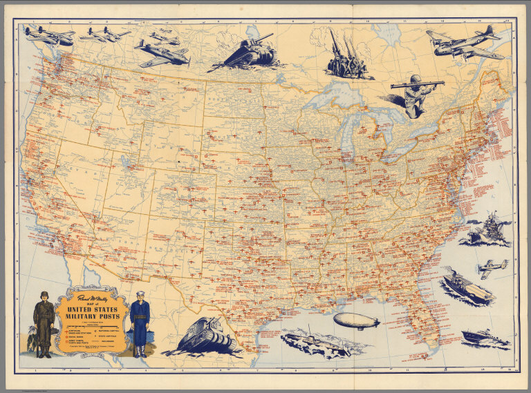
Author
Rand McNally & Co.
Full Title
(Covers to) Map of United States Military Posts.
Publisher
Rand McNally & Co.
Author
Rand McNally & Co.
Full Title
(Text Page) List of United States Military Posts. Army and Navy Plane Silhouettes. USO Clubs.
Publisher
Rand McNally & Co.
Author
Rand McNally & Co.
Full Title
Rand McNally Map of United States Military Posts.
Publisher
Rand McNally & Co.
Author
[Lane, John J., New England Street Railway Club]
Full Title
(Covers to)Trolley Wayfinder : birds eye view of trolley routes in New England. Published by the New England street Railway Club. ... John J. Lane Editor of "Trolley Wayfinder" and Trolley Wayfinder birds eye view of trolley routes. 12 Paerl St. Boston. Copyright 1904, 1905, 1906 & 1907 by the New England Street Railway Club.Price 10 Cents. (with) Trolley Wayfinder : birds eye view of trolley routes in New England. New England street Railway Club ... Geo. H. Walker & Co. Boston. (with 7 insets).
Publisher
[New England Street Railway Club, Geo. H. Walker & Co.]
Author
[Lane, John J., New England Street Railway Club]
Full Title
(Text Page to)Trolley Wayfinder : birds eye view of trolley routes in New England. New England street Railway Club. 12 Pearl St. Copyright 1904, 1905, 1906, 1907, by the New England Street Railway Club. Geo. H. Walker & Co. Boston. (with 7 insets). (cover title) Trolley Wayfinder : birds eye view of trolley routes in New England. Published by New England street Railway Club. ... John J. Lane Editor of "Trolley Wayfinder" and Trolley Wayfinder birds eye view of trolley routes. Price 10 Cents.
Publisher
[New England Street Railway Club, Geo. H. Walker & Co.]
Author
[Lane, John J., New England Street Railway Club]
Full Title
Trolley Wayfinder : birds eye view of trolley routes in New England. New England street Railway Club. 12 Pearl St. Copyright 1904, 1905, 1906, 1907, by the New England Street Railway Club. Geo. H. Walker & Co. Boston. (with 7 insets). (cover title) Trolley Wayfinder : birds eye view of trolley routes in New England. Published by New England street Railway Club. ... John J. Lane Editor of "Trolley Wayfinder" and Trolley Wayfinder birds eye view of trolley routes. Price 10 Cents.
Publisher
[New England Street Railway Club, Geo. H. Walker & Co.]
Author
[Young, Arthur S., Chichester, Francis]
Full Title
(Covers to) London to Paris : This passenger - amusement map has been specially produced and published for British European Airways by Francis Chichester, 9 St. James's Place, London, S.W. 1. Arthist- Arthur S. Young. Printed by Harrison & Sons, Ltd., London and High Wycombe. (on lower left margin) BEA 311 (100M). (Cover title) Keyline Maps : BEA London - Paris British European Airways : Picture map; The key to Europe.
Publisher
Harrison & Sons Ltd.
Author
[Young, Arthur S., Chichester, Francis]
Full Title
London to Paris : This passenger - amusement map has been specially produced and published for British European Airways by Francis Chichester, 9 St. James's Place, London, S.W. 1. Arthist- Arthur S. Young. Printed by Harrison & Sons, Ltd., London and High Wycombe. (on lower left margin) BEA 311 (100M). (Cover title) Keyline Maps : BEA London - Paris British European Airways : Picture map; The key to Europe.
Publisher
Harrison & Sons Ltd.
Author
Lingren, Jolly
Full Title
(Covers to) A Hysterical Map of Death Valley National Monument and It's Lookin' Mighty Low.
Publisher
Lindgren Brothers
Author
Lingren, Jolly
Full Title
A Hysterical Map of Death Valley National Monument and It's Lookin' Mighty Low.
Publisher
Lindgren Brothers
Author
[Lites, Arthur, (Palo Alto) Chamber of Commerce]
Full Title
(Covers to) A Pictorial Map of Palo Alto and San Francisco Peninsula by Arthur Lites. Palo Alto, California. A Pictorial Map. Home of Stanford University.
Publisher
City of Palo Alto
Author
[Lites, Arthur, (Palo Alto) Chamber of Commerce]
Full Title
(Text Page) A Pictorial Map of Palo Alto and San Francisco Peninsula by Arthur Lites. Palo Alto, California. A Pictorial Map. Home of Stanford University.
Publisher
City of Palo Alto
Author
[Lites, Arthur, (Palo Alto) Chamber of Commerce]
Full Title
A Pictorial Map of Palo Alto and San Francisco Peninsula by Arthur Lites.
Publisher
City of Palo Alto
Author
Lindgren Brothers
Full Title
A Hysterical Map of the Yellowstone Park with Apologies to the Park. Smileage Guaranteed. Lindgren Brothers. Spokane, Wash. C(opyright)1936.
Publisher
Lindgren Brothers
Author
Eddy, Gerald A.
Full Title
(Covers to) Lake Tahoe - Sierra Association. California -- Nevada.
Publisher
Lake Tahoe Sierra Association
Author
Eddy, Gerald A.
Full Title
(Text Page) Lake Tahoe - Sierra Association. California -- Nevada.
Publisher
Lake Tahoe Sierra Association
Author
Eddy, Gerald A.
Full Title
Lake Tahoe - Sierra Association. California -- Nevada.
Publisher
Lake Tahoe Sierra Association
Author
Atwood, Mary Hall (1894-1950)
Full Title
(Covers to) The Tenth Olympic Games Los Angeles, California, July 30 - Aug. 14 '32. Designed and Illustrated by Mary Hall Atwood. A Complete Map of Los Angeles Area and Guide to Olympic Games.
Publisher
Union Oil Company
Author
Atwood, Mary Hall (1894-1950)
Full Title
(Text Page) The Tenth Olympic Games Los Angeles, California, July 30 - Aug. 14 '32.
Publisher
Union Oil Company
Author
Atwood, Mary Hall (1894-1950)
Full Title
The Tenth Olympic Games Los Angeles, California, July 30 - Aug. 14 '32. Designed and Illustrated by Mary Hall Atwood. A Complete Map of Los Angeles Area and Guide to Olympic Games.
Publisher
Union Oil Company
Author
[Lites, Arthur, (Palo Alto) Chamber of Commerce]
Full Title
(Covers to) A Pictorial Map of Palo Alto and San Francisco Peninsula by Arthur Lites. Palo Alto, California. A Pictorial Map. Home of Stanford University.
Publisher
City of Palo Alto
Author
[Lites, Arthur, (Palo Alto) Chamber of Commerce]
Full Title
(Text Page) A Pictorial Map of Palo Alto and San Francisco Peninsula by Arthur Lites. Palo Alto, California. A Pictorial Map. Home of Stanford University.
Publisher
City of Palo Alto
Author
[Lites, Arthur, (Palo Alto) Chamber of Commerce]
Full Title
A Pictorial Map of Palo Alto and San Francisco Peninsula by Arthur Lites.
Publisher
City of Palo Alto
Author
[Lites, Arthur, (Palo Alto) Chamber of Commerce]
Full Title
(Covers to) A Pictorial Map of Palo Alto and San Francisco Peninsula by Arthur Lites. Palo Alto, California. A Pictorial Map. Home of Stanford University.
Publisher
City of Palo Alto
Author
[Lites, Arthur, (Palo Alto) Chamber of Commerce]
Full Title
(Text Page) A Pictorial Map of Palo Alto and San Francisco Peninsula by Arthur Lites. Palo Alto, California. A Pictorial Map. Home of Stanford University.
Publisher
City of Palo Alto
Author
[Lites, Arthur, (Palo Alto) Chamber of Commerce]
Full Title
A Pictorial Map of Palo Alto and San Francisco Peninsula by Arthur Lites.
Publisher
City of Palo Alto
Author
Chase, Ernest Dudley, 1878-1966
Full Title
Boston (Massachusetts) and Vicinity. A Pictorial Map by Ernest Dudley Chase of Winchester, Massachusetts.
Publisher
Ernest Dudley Chase
|