|
Author
Chase, Ernest Dudley, 1878-1966
Full Title
Japan, the target : a pictorial Jap-map : By Ernest Dudley Chase of Winchester, Mass. Published and copyright, Ernest Dudley Chase, Winchester, Mass. Printed in U.S.A.
Publisher
Ernest Dudley Chase
Author
National Park Service
Full Title
Southwestern National Monuments. Headquarters at Casa Grande National Monument. United States Department of the Interior, Harold L. Ickes, Secretary. National Park Service.
Publisher
U.S. Government Printing Office
Author
Colortext Publications, Inc.
Full Title
The Story Map of Scotland.
Publisher
Colortext Publications, Inc.
Author
Forest Lawn Memorial-Park
Full Title
Pictorial Map and Visitor's Guide to Forest Lawn Memorial-Park, Glendale, California.
Publisher
Forest Lawn Memorial-Park
Author
Mortimer, Carina Eaglesfield
Full Title
New Haven. Published by the Edward P. Judd Co., New Haven Conn., Copyrighted 1928. Drawn by Carina Eaglefield Mortimer - Architect.
Publisher
Edward P. Judd Co.
Author
Colonial Craftsmen
Full Title
Decorative Map of Cape Cod. The Reaches of Cape Cod, Nantucket, and Martha's Vineyard, Massachusetts. Copyrighted 1940 ... Colonial Craftsmen, P.O.912, Attleboro, Massachusetts.
Publisher
Colonial Craftsmen
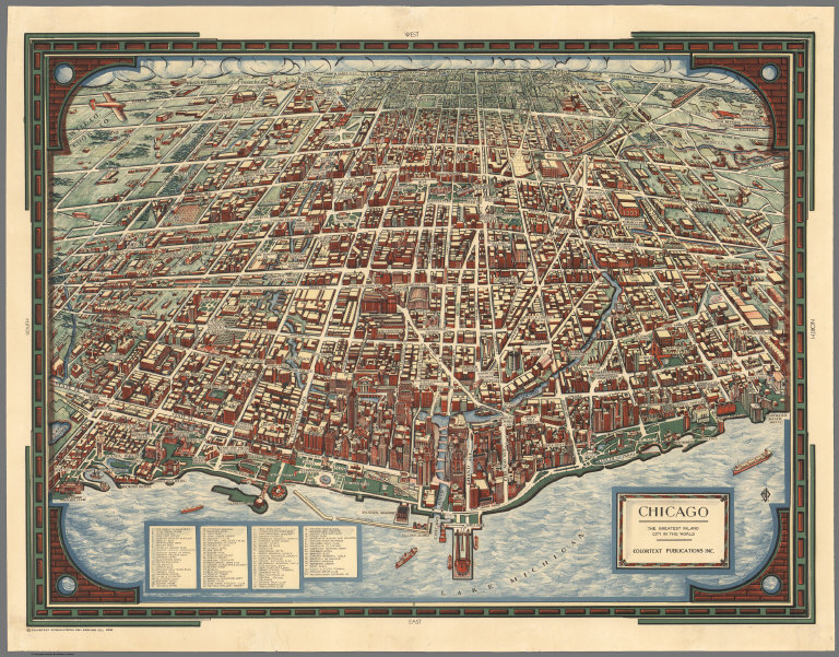
Author
Colortext Publications, Inc.
Full Title
Chicago. The Greatest Inland City in the World. Colortext Publications, Inc.
Publisher
Colortext Publications, Inc.
Author
Tyng, Griswold (1883-1960)
Full Title
Map of Boston Common with Surrounding Streets & Adjacent Parts of Beacon Hill. Designed by Griswold Tyng. (c) Published by Little, Brown & Co.
Publisher
Little, Brown & Co.
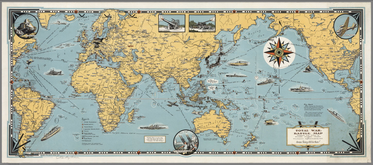
Author
Chase, Ernest Dudley, 1878-1966
Full Title
Total War, Battle Map. Designed and Drawn by Ernest Dudley Chase of Winchester, Massachusetts, U.S.A. Certain Victory Will be Ours.
Publisher
Ernest Dudley Chase
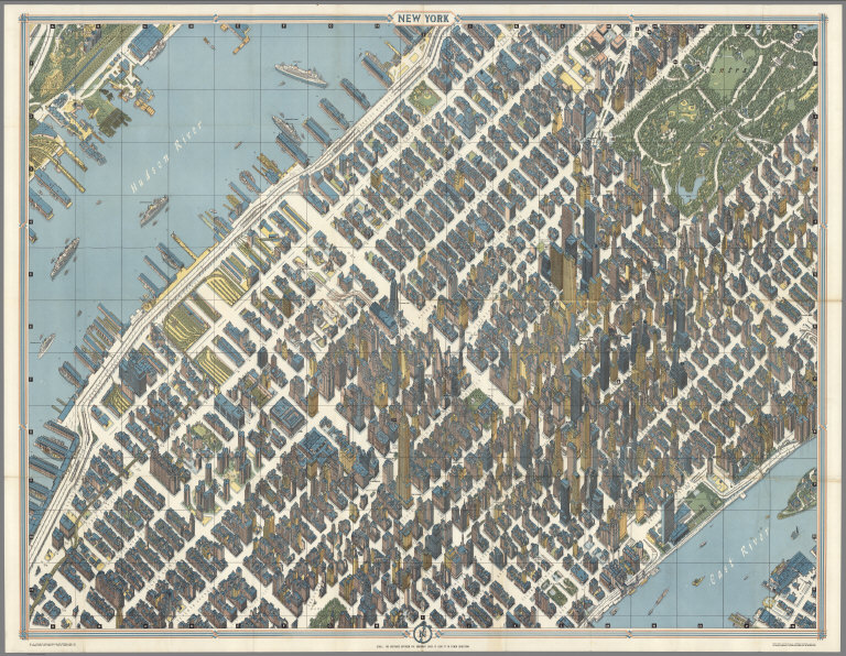
Author
Bollmann, Hermann (1911-1971)
Full Title
New York (City) Picture Map.
Publisher
Pictorial Maps, Inc.
Author
Bollmann, Hermann (1911-1971)
Full Title
New York (City) Picture Map.
Publisher
Pictorial Maps, Inc.
Author
Bollmann, Hermann (1911-1971)
Full Title
New York (City) Picture Map.
Publisher
Pictorial Maps, Inc.
Author
Johnstone, E. McD.
Full Title
The Unique Map Of California. Copyrighted. E. McD. Johnstone. Dickman-Jones Co. Lith. S.F. (with 3 inset maps, 1 profile).
Publisher
Dickman Jones Co. Lith.
Author
[Purdy, Earl, United States. Public Works Administration. Division of Information]
Full Title
PWA rebuilds the Nation. Prepared by Division of Information, Federal Public Works Administration. Cartographer Earl Purdy.
Publisher
Division of Information Federal Public Works Administration.
Author
General Drafting Company
Full Title
Trip Planning Map Of The United States. Happy Motoring! Humble Oil & Refining Company; America's leading Energy Company." Lithographed in U.S.A. W 162. (copyright) MCMLXII, general Drafting Co., Inc., Convent Station, N.J. (inset) Alaska. (inset) Hawaii. (on verso) The United States Trip Planner. (prepared for) Humble Oil & Refining Company. (copyright) MCMLXII, general Drafting Co., Inc., Convent Station, N.J.
Publisher
General Drafting Co.
Author
Maduro Jr., I.L.
Full Title
(Covers to) Bird's Eye View of the Panama Canal and Map of Panama. I.L. Maduro Jr, Panama.
Publisher
I.L. Maduro Jr.,
Author
Maduro Jr., I.L.
Full Title
(Text Page) (Panama Canal Photographs and Descriptions).
Publisher
I.L. Maduro Jr.,
Author
New Mexico State Tourist Bureau
Full Title
(Covers to) Recreational map of New Mexico land of enchantment. (on verso) Recreational map of New Mexico : the land of enchantment. Printed ... distributed by the New Mexico State Tourist Bureau a division of the State Highway Department, State Capitol, Santa Fe. Copyright 1946, New Mexico State Tourist Bureau, Santa Fe, New Mexico. Litho. in U.S.
Publisher
New Mexico State Tourist Bureau a division of the State Highway Department
Author
New Mexico State Tourist Bureau
Full Title
(Text Page to) Recreational map of New Mexico land of enchantment (with tourist information) Parks and monuments, Highways, Climate, Sports, Indians, Mountains, The old West. (on verso) Recreational map of New Mexico : the land of enchantment. Printed ... distributed by the New Mexico State Tourist Bureau a division of the State Highway Department, State Capitol, Santa Fe. Copyright 1946, New Mexico State Tourist Bureau, Santa Fe, New Mexico. Litho. in U.S.
Publisher
New Mexico State Tourist Bureau a division of the State Highway Department
Author
New Mexico. State Tourist Bureau
Full Title
Historical trails through New Mexico : the land of enchantment ; prepared for free distribution by the New Mexico State Tourist Bureau, a Division of the State Highway Department, Santa Fe, New Mexico. Litho. by Johnson Printing Inc., Eau. Claire Wis. Copyright 1951, New Mexico State Tourist Bureau, Santa Fe, New Mexico. (on verso: cover title and text).
Publisher
[New Mexico State Tourist Bureau, Johnson Printing Inc.]
Author
Williams, Robert
Full Title
The Mystery Map of Assinine Atoll. (c)opyright Robert Williams, 77.
Publisher
No Publisher
Author
McCandlish, Edward
Full Title
Bootlegger's Map of the United States "Honi soit qui mal y pints". Copyright by Edward McCandlish. The Griswold Press- Printed in U.S.A.
Publisher
Griswold Press
Author
[Aaron Blake Publishers, Zeleznik, John, Lewis, Susan]
Full Title
The Ian Fleming Thriller Map.
Publisher
Aaron Blake Publishers
Author
Gill, Leslie MacDonald, 1884-1947
Full Title
(Covers to) The Wonderground Map of London Town. Drawn by MacDonald Gill. Printed and Published by the Westminster Press, 11 Henrietta Street, Covent Garden, London, W.C.
Publisher
Westminster Press
Author
Goff, Errol W.
Full Title
(Covers to) A Picture Map of Cape Ann and the North Shore.
Publisher
Houghton Mifflin Co.
Author
[Army Information Branch, Navy Educational Services Section]
Full Title
(View) Comparison Chart of Non-Commissioned Grades and Ratings of the Armed Forces.
Publisher
Army Information Branch, Army Service Forces
Author
Petersen, C.C.
Full Title
(Covers to) Your Dated War Map. Dated Events War Map.
Publisher
Shaw-Barton
Author
Petersen, C.C.
Full Title
Your Dated War Map. Dated Events War Map.
Publisher
Shaw-Barton
Author
Suchy, Arthur B.
Full Title
(Covers to) The heart of Cleveland, Ohio. Forest City. Cleveland, Ohio. 1928. (Copyright) by Arthur B. Suchy. The Du Bois Press, Rochester, N.Y. "Scale street layout 13 1/2 inches to 1 mile. buildings, figures and the rest have no scale".
Publisher
The Du Bois Press
Author
Standard Oil
Full Title
(Covers to) Pictorial Map of the Americas featuring the Pan American Highway.
Publisher
Standard Oil
Author
Standard Oil
Full Title
(Text Page) Know Your Neighbors Better.
Publisher
Standard Oil
Author
Alcoa Map Department, Aluminum Company of America
Full Title
(Covers to) Global Map for Global War and Global Peace. Vacations for All.
Publisher
Aluminum Company of America (Alcoa)
Author
Alcoa Map Department, Aluminum Company of America
Full Title
(Diagrams) (Aircraft Profiles. Aircraft Maneuvers. Military Insignia. Types of Aluminum. Aircraft Construction Details).
Publisher
Aluminum Company of America (Alcoa)
Author
Scheuerle, Joe (1873-1948)
Full Title
(Text Page) Great Northern Recreational Map of Glacier National Park Montana, Waterton Lakes National Park Alberta.
Publisher
Great Northern Railway
Author
Scheuerle, Joe (1873-1948)
Full Title
(Text Page) Great Northern Recreational Map of Glacier National Park Montana, Waterton Lakes National Park Alberta.
Publisher
Great Northern Railway
Author
Rand McNally & Co.
Full Title
(Covers to) Map of United States Military Posts.
Publisher
Rand McNally & Co.
Author
Rand McNally & Co.
Full Title
(Text Page) List of United States Military Posts. Army and Navy Plane Silhouettes. USO Clubs.
Publisher
Rand McNally & Co.
Author
Lingren, Jolly
Full Title
(Covers to) A Hysterical Map of Death Valley National Monument and It's Lookin' Mighty Low.
Publisher
Lindgren Brothers
Author
[Lites, Arthur, (Palo Alto) Chamber of Commerce]
Full Title
(Covers to) A Pictorial Map of Palo Alto and San Francisco Peninsula by Arthur Lites. Palo Alto, California. A Pictorial Map. Home of Stanford University.
Publisher
City of Palo Alto
Author
[Lites, Arthur, (Palo Alto) Chamber of Commerce]
Full Title
(Text Page) A Pictorial Map of Palo Alto and San Francisco Peninsula by Arthur Lites. Palo Alto, California. A Pictorial Map. Home of Stanford University.
Publisher
City of Palo Alto
Author
Eddy, Gerald A.
Full Title
(Covers to) Lake Tahoe - Sierra Association. California -- Nevada.
Publisher
Lake Tahoe Sierra Association
Author
Eddy, Gerald A.
Full Title
(Text Page) Lake Tahoe - Sierra Association. California -- Nevada.
Publisher
Lake Tahoe Sierra Association
Author
Eddy, Gerald A.
Full Title
Lake Tahoe - Sierra Association. California -- Nevada.
Publisher
Lake Tahoe Sierra Association
Author
Atwood, Mary Hall (1894-1950)
Full Title
(Covers to) The Tenth Olympic Games Los Angeles, California, July 30 - Aug. 14 '32. Designed and Illustrated by Mary Hall Atwood. A Complete Map of Los Angeles Area and Guide to Olympic Games.
Publisher
Union Oil Company
Author
Atwood, Mary Hall (1894-1950)
Full Title
(Text Page) The Tenth Olympic Games Los Angeles, California, July 30 - Aug. 14 '32.
Publisher
Union Oil Company
Author
[Lites, Arthur, (Palo Alto) Chamber of Commerce]
Full Title
(Covers to) A Pictorial Map of Palo Alto and San Francisco Peninsula by Arthur Lites. Palo Alto, California. A Pictorial Map. Home of Stanford University.
Publisher
City of Palo Alto
Author
[Lites, Arthur, (Palo Alto) Chamber of Commerce]
Full Title
(Text Page) A Pictorial Map of Palo Alto and San Francisco Peninsula by Arthur Lites. Palo Alto, California. A Pictorial Map. Home of Stanford University.
Publisher
City of Palo Alto
Author
[Lites, Arthur, (Palo Alto) Chamber of Commerce]
Full Title
(Covers to) A Pictorial Map of Palo Alto and San Francisco Peninsula by Arthur Lites. Palo Alto, California. A Pictorial Map. Home of Stanford University.
Publisher
City of Palo Alto
Author
[Lites, Arthur, (Palo Alto) Chamber of Commerce]
Full Title
(Text Page) A Pictorial Map of Palo Alto and San Francisco Peninsula by Arthur Lites. Palo Alto, California. A Pictorial Map. Home of Stanford University.
Publisher
City of Palo Alto
|