Who What Where WhenREMOVEWHEREShow More |
Author
Chase, Ernest Dudley, 1878-1966
Full Title
A pictorial map of Switzerland, by Ernest Dudley Chase of Winchester, Massachusetts, U.S.A. Copyright 1936, Ernest Dudley Chase. Winchester, Mass. U.S.A.
Publisher
Ernest Dedley Chase
Author
Chase, Ernest Dudley, 1878-1966
Full Title
A pictorial map of Spain and Portugal, by Ernest Dudley Chase of Winchester, Massachusetts. Copyright 1935, Ernest Dudley Chase.
Publisher
Ernest Dedley Chase
Author
Chase, Ernest Dudley, 1878-1966
Full Title
France as drawn by Ernest Dudley Chase of Winchester, Massachusetts. U.S.A.Copyright 1935, Ernest Dudley Chase.
Publisher
Ernest Dedley Chase
Author
Paine, Paul M.
Full Title
Booklovers Map of America: A Chart of Certain Landmarks of Literary Geography. Copyright 1926; Paul M. Paine. R. R. Walker Co. 62 W. 45th St. New York N.Y. (with 6 insets and location map).
Publisher
R.R. Bowker Co.
Author
Berry, William D.
Full Title
Alaska. W. D. Berry. Copyright Griffins, Alaska 1967. (with key map) Key to Alaska plant and wildlife map, by William D. Berry.
Publisher
Griffin
Author
Berry, William D.
Full Title
Key to Alaska plant and wildlife map, by William D. Berry. (with) Alaska. W. D. Berry. Copyright Griffins, Alaska 1967.
Publisher
Griffin
Author
Jacobson, Egbert, G.
Full Title
The story map of England. Egbert G. Jacobson. Colortext Publications, Chicago.
Publisher
Colortext Publications, Inc.
Author
[Walker, A, Vogelear., W.E.]
Full Title
Story map of France. Colortext Publications, Inc., Chicago 1936. A. Walker W.E. Vogelear. Border design and decorations from 17th century Louis Quinze tapestries and 18th century Robert de Cotte ornaments.
Publisher
Colortext Publications, Inc.
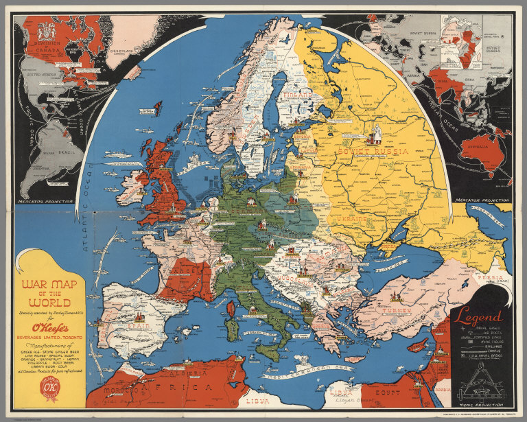
Author
Turner, Stanley
Full Title
War map of the world : specially executed by Stanley Turner A.R.C.A. for O'Keef's Beverages Limited, Toronto. Conic Projection. Copyright C.C. Petersen Advertising, 57 Queen St. W., Toronto. (Western hemisphere. Part of the Eastern hemisphere). British & French empires in Africa.
Publisher
C.C. Petersen Publishing and Advertising
Author
Chase, Ernest Dudley, 1878-1966
Full Title
Italy, with Vatican City : as drawn and published by Ernest Dudley Chase of Winchester, Massachusetts, USA. Copyright, Ernest Dudley Chase. U.S.A. (inset) Vatican City, area about 109 acres.
Publisher
Ernest Dudley Chase
Author
Chase, Ernest Dudley, 1878-1966
Full Title
France: as drawn and published by Ernest Dudley Chase of Winchester, Massachusetts, USA. Copyright, Ernest Dudley Chase.
Publisher
Ernest Dudley Chase
Author
Chase, Ernest Dudley, 1878-1966
Full Title
The story map of flying : Being a chronicle of man's conquest of the air : Designed, pictured and published by Ernest Dudley Chase of Winchester, Massachusetts, U.S.A. Copyright, Ernest Dudley Chase Winchester, Mass., U.S.A.
Publisher
Ernest Dudley Chase
Author
[Turzak, Charles, Chapman, Henry T.]
Full Title
Chicago. U.S.A. Designed by Charles Turzak and Henry T. Chapman. Copyright, 1931, by Houghton Mifflin Company. Litho. in U.S.A. The Tudor Press, Boston. (on borders) An illustrated map of Chicago : youthful city of the big shoulders, restless, ingenious, wilful, violent, proud to be alive.
Publisher
Houghton Mifflin Compay
Author
Chase, Ernest Dudley, 1878-1966
Full Title
Japan, the target : a pictorial Jap-map : By Ernest Dudley Chase of Winchester, Mass. Published and copyright, Ernest Dudley Chase, Winchester, Mass. Printed in U.S.A.
Publisher
Ernest Dudley Chase
Author
National Park Service
Full Title
Southwestern National Monuments. Headquarters at Casa Grande National Monument. United States Department of the Interior, Harold L. Ickes, Secretary. National Park Service.
Publisher
U.S. Government Printing Office
Author
[Pearcy, G. Etzel, Fabatz, Anton B.]
Full Title
World Air Transportation, Principal Routes of Scheduled Commercial Airlines. Published by the National Council of Geography Teachers.
Publisher
National Council of Geography Teachers
Author
[Allan Cartography, Dynamic Graphics, Inc.]
Full Title
Tectonic California. Dynamic Graphics, Inc. ... Berkeley, California 94705 ....
Publisher
Dynamic Graphics, Inc.
Author
Civil Aeronautics Board
Full Title
United States Air Transportation System, Routes Permanently Certified, September 30, 1953. Civil Aeronautics Board, Bureau of Air Operations, Routes and Carrier Relations.
Publisher
Civil Aeronautics Board
Author
Rand McNally & Company
Full Title
Baltimore & Ohio Railroad Geographically Correct Map of Northeastern United States.
Publisher
Rand McNally & Company
Author
Rand McNally & Company
Full Title
Geographically Correct Map of the United States Issued by Baltimore & Ohio Railroad. (insets) Alaska. Hawaii.
Publisher
Rand McNally & Company
Author
American Aviation Publications
Full Title
Airline Map of the United States 1961. Compiled by Official Airline Guide ... Copyright by American Aviation Publications, Inc.
Publisher
American Aviation Publications
Author
Chase, Ernest Dudley, 1878-1966
Full Title
The Pictorial Map, Stamps of the U.S.A. Dedicated to Philatelists Everywhere designed, drawn, and published by Ernest Dudley Chase, Winchester - Massachusetts, U.S.A.
Publisher
Chase, Ernest Dudley
Author
Colortext Publications, Inc.
Full Title
The Story Map of Scotland.
Publisher
Colortext Publications, Inc.
Author
Forest Lawn Memorial-Park
Full Title
Pictorial Map and Visitor's Guide to Forest Lawn Memorial-Park, Glendale, California.
Publisher
Forest Lawn Memorial-Park
Author
Jeppesen and Company
Full Title
Routes of Pan American World Airways System. Second Printing 7515M. Copyright 1951 by Pan American World Airways, Inc. Clipper Trademark Registered ... Prepared by Jeppesen and Company, Denver, Colorado, U.S.A.
Publisher
Pan American World Airways, Inc.
Author
Mortimer, Carina Eaglesfield
Full Title
New Haven. Published by the Edward P. Judd Co., New Haven Conn., Copyrighted 1928. Drawn by Carina Eaglefield Mortimer - Architect.
Publisher
Edward P. Judd Co.
Author
Colonial Craftsmen
Full Title
Decorative Map of Cape Cod. The Reaches of Cape Cod, Nantucket, and Martha's Vineyard, Massachusetts. Copyrighted 1940 ... Colonial Craftsmen, P.O.912, Attleboro, Massachusetts.
Publisher
Colonial Craftsmen
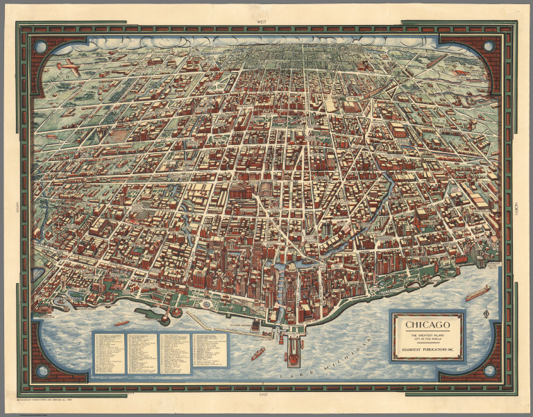
Author
Colortext Publications, Inc.
Full Title
Chicago. The Greatest Inland City in the World. Colortext Publications, Inc.
Publisher
Colortext Publications, Inc.
Author
Tyng, Griswold (1883-1960)
Full Title
Map of Boston Common with Surrounding Streets & Adjacent Parts of Beacon Hill. Designed by Griswold Tyng. (c) Published by Little, Brown & Co.
Publisher
Little, Brown & Co.
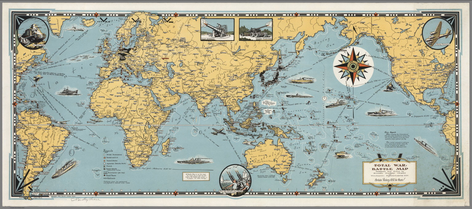
Author
Chase, Ernest Dudley, 1878-1966
Full Title
Total War, Battle Map. Designed and Drawn by Ernest Dudley Chase of Winchester, Massachusetts, U.S.A. Certain Victory Will be Ours.
Publisher
Ernest Dudley Chase
Author
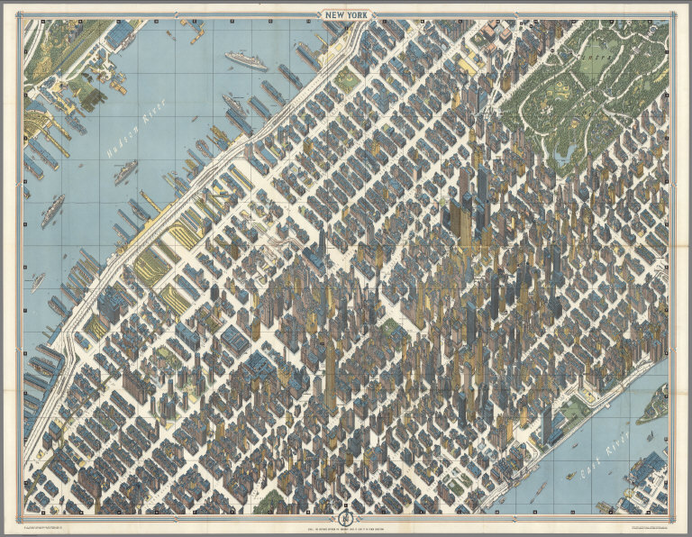
Bollmann, Hermann (1911-1971)
Full Title
New York (City).
Publisher
Pictorial Maps, Inc.
Author
Bollmann, Hermann (1911-1971)
Full Title
New York (City) Picture Map.
Publisher
Pictorial Maps, Inc.
Author
Bollmann, Hermann (1911-1971)
Full Title
New York (City).
Publisher
Pictorial Maps, Inc.
Author
Bollmann, Hermann (1911-1971)
Full Title
New York (City) Picture Map.
Publisher
Pictorial Maps, Inc.
Author
Bollmann, Hermann (1911-1971)
Full Title
New York (City).
Publisher
Pictorial Maps, Inc.
Author
Bollmann, Hermann (1911-1971)
Full Title
New York (City) Picture Map.
Publisher
Pictorial Maps, Inc.
Author
Lapham, I.A.
Full Title
Map Of Milwaukee. Population In 1835 None, In 1843 6068, In 1847 14,061!, In 1850 20,061. By I.A. Lapham. 1856. Eng. by Sherman & Smith, N.Y. Population In 1855, 30,448. (inset map) Glidden & Lockwood's Addition.
Publisher
Sherman and Smith
Author
Lewis, Samuel
Full Title
A New Map Of The Seat Of War. S. Lewis. del. J. Bower, Sct. (with inset map) Niagara River.
Publisher
No Publisher
Author
Magnus, Charles
Full Title
Panorama Of The Mississippi Valley And Its Fortifications. Published by C. Magnus, 12 Frankfort Street, New York. Eng. by F.W. Boell.
Publisher
Charles Magnus
Author
Magnus, Charles
Full Title
One Hundred & Fifty Miles Around Richmond. Charles Magnus' New York Printing Establishment - Offices: 12 Frankfort St., New York, and 520 7th St. Washington, D.C. Eleventh Edition 3000 of Magnus' all around Map ... Battle Ground of the Wilderness and Spottsylvania Court House. May, 5-23, 1864. Price 50 Cents. (with 9 small maps) Memphis And Nashville, Tenn. 225 Miles Around Vicksburg, Miss. 250 Miles Around Galveston, Texas. 200 Miles Around Montgomery, Ala. 100 Miles Around Milledgeville, Ga. Fortifications Around Richmond, Va. 250 Miles Around Charleston, S.C. 100 Miles Around Chattanooga, Tenn. Knoxville, Tenn., Danville, Ky. And Parkersburg, Va.
Publisher
Charles Magnus
Author
Melish, John
Full Title
Map of Illinois Constructed from the Surveys in the General Land Office and other Documents By John Melish. Saml. Harrison, sct. Entered according to Act of Congress the 16th day of April 1818. Philadelphia. Published by John Melish. Improved to 1820.
Publisher
John Melish
Author
[Kensett, T., Shelton, W.]
Full Title
Shelton & Kensett's Map Of The State Of Indiana. Protracted from manuscript surveys communicated to the publishers By the Honorable Christopher Harrison. Lieut. Govr. of that State, to which are added the surveys of the Illinois Territory By Genl. Mansfield. Engraved by A. Doolittle, New Haven. (with) A Sketch of the existing connection of the State of Indiana and Illinois Territory, with the adjoining States. Entered ... 25th day of Decr. 1817 by Shelton & Kensett.
Publisher
Shelton & Kensett
Author
Anonymous
Full Title
United States.
Publisher
No Publisher
Author
Newport, California
Full Title
California Map Showing San Francisco, Newport. Rail Road Connections With The Adjacent Country. (with: A Deed for lot 37 in Block 392 in the City of Newport to William H. Carr, of Mount Vernon, Kennebec County, State of Maine).
Publisher
No Publisher
Author
Magnus, Charles
Full Title
Map of The City of Buffalo. Chs. Magnus lith. New York. (Hand colored map on a letter sheet).
Publisher
Charles Magnus
Author
Britton & Rey
Full Title
Map of San Francisco, Compiled from latest Surveys & containing all late extensions & Division of Wards. Published By Britton & Rey, San Francisco Cal.
Publisher
Britton & Rey
Author
Weekly Pantagraph
Full Title
The Weekly Pantagraph's Premium Map Of McLean County, Ill. 1886. Copyrighted & Published By J.S. Hambaugh, Chicago. Geo. P. Ela, Civil And Drainage Engineer, Bloomington, Ill.
Publisher
J.S. Hambaugh
Author
Cook, James
Full Title
A Map of the Province of South Carolina with all the Rivers, Creeks, Bays, Inletts, Islands, Inland Navigation, Soundings, Time of High Water on the Sea Coast, Roads, Marshes, Ferrys, Bridges, Swamps, Parishes Churches, Towns, Townships; Country Parish District and Provincial Lines. Humbly inscribed to the Hon.ble Lawlins Lownds Esqr. Speaker & the rest of the Members of the Hon.ble the Commons House of Assembly of the Province by their most Obedt. & faithfull Servt Jams Cook. Thos. Bowen, sculpt. 1773. (with 6 inset maps).
Publisher
No Publisher
Author
Lloyd, J. T.
Full Title
Lloyd's Map Of The Southern States Showing all the Railroads, their Stations & Distances, Also The Counties, Towns, Villages, Harbors, Rivers And Forts. Compiled from the latest Government and other reliable Sources. 1861. New York, J.T. Lloyd Publisher 164 Broadway. London " 156 Cheapside. Entered ... 1861, by J.T. Lloyd ... New York.
Publisher
J.T. Lloyd
Author
Mallory, C.A.
Full Title
Part of the North Bank of the Rappahannock River showing the approaches to Fredericksburg, prepared under the direction of Capt. R.S. Williamson & 1st Lt. Nicholas Bowen ... for the use of the Army of the Potomac compiled by Fred. Churchill Vol. A.D.C. U.S. Coast Survey Chart of the Rappahannock River Surveys and Reconnoissances by C.A. Mallory, Chas. Shoemacker, L.C. Oswell, H.H. Marvin, Geo. F. Lathrop, Assistants. Drawn by C.A. Mallory. Reduced and photographed by L.E. Walker, Treasy. Dept.
Publisher
U.S. Treasury Dept.
|