Who What Where WhenREMOVEWHEREShow More |
Author
Coney, Peter
Full Title
Geologic Cross Section of the Cedar Breaks - Zion - Grand Canyon Region.
Publisher
Zion Natural History Association
Author
Breed, William J.
Full Title
Geologic Cross Section of the Grand Canyon Region - San Francisco Peaks - Verde Valley Region.
Publisher
Zion Natural History Association
Author
CSAA (California State Automobile Association)
Full Title
Routes to Yosemite National Park. Copyright by the California State Automobile Association.
Publisher
CSAA (California State Automobile Association)
Author
CSAA (California State Automobile Association)
Full Title
Roads in Yosemite Valley. Routes to Yosemite National Park. Map Issued by California State Automobile Association.
Publisher
CSAA (California State Automobile Association)
Author
[Shurtleff, Elizabeth, McMillin, Helen F.]
Full Title
A Map of the Bermuda Islands. Sa des Demonias Isles of the Devils.
Publisher
[Elizabeth Shurtleff, Helen F. McMillin]
Author
Bollmann, Hermann (1911-1971)
Full Title
New York (City) Picture Map.
Publisher
Pictorial Maps, Inc.
Author
Colortext Publications Inc.
Full Title
Story Map of Ireland.
Publisher
Colortext Publications Inc.
Author
Chase, Ernest Dudley, 1878-1966
Full Title
Total War, Battle Map. Designed and Drawn by Ernest Dudley Chase of Winchester, Massachusetts, U.S.A. Certain Victory Will be Ours.
Publisher
Ernest Dudley Chase
Author
Chase, Ernest Dudley, 1878-1966
Full Title
World Wonders, A Pictorial Map. Designed and Drawn by Ernest Dudley Chase of Winchester, Mass.
Publisher
Ernest Dudley Chase
Author
Chase, Ernest Dudley, 1878-1966
Full Title
The pictorial map : United States Stamps. Designed, drawn and published by Ernest Dudley Chase. Winchester, Mass.; Research directors Charles Peck Kerr and Rupert Frank Jones. The post : Artists: Famous American Commemorative Series -- 1940.
Publisher
Ernest Dudley Chase.
Author
Sarg, Anthony
Full Title
Residential Main St. Nantucket Mass. Designed by Tony Sarg. 1937.
Publisher
No Publisher
Author
[Bauer Hubert A., Air-Age Education Research]
Full Title
World around the United States : Map of proposed world air routes : for United States flag carriers airline time-distance chart and chronological history of the progress of aviation; Developed by Air-Age Educational Research. H.A. Bauer, Cartographer - Copyright by American Airlines, Inc. Second edition - Printed in U.S.A. - Published in January 1946. contributed by American Airlines System ... and distributed as a Teacher service by Young America. (with inset).
Publisher
Air-Age Education Research
Author
Sheets, Millard
Full Title
The Panorama Today in Northern California its resources activities and opportunities. Published on its 100th. Anniversary by American Trust Company, San Francisco. Millard Sheets. Lithogravure in U.S.A.
Publisher
American Trust Company
Author
Sheets, Millard
Full Title
The Pageant of History in Northern California its colorful and adventurous beginnings. Published on its 100th. Anniversary by American Trust Company, San Francisco. Millard Sheets. Lithogravure in U.S.A.
Publisher
American Trust Company
Author
Paine, Paul M.
Full Title
Map of America's making : a chart of places and events for those who would sail with the discoverers, seek freedom with the colonists, follow the westward trails, subdue the wilderness, and behold the building of the Republic. F. Haase. Copyright by Paul M. Paine, 1925 - 1926 - 1929 - 1939. R.R. Bowker Company. 62 West 45th Street, New York, N.Y. (inset) Where American History began [Northeast.].
Publisher
R.R. Bowker Co.
Author
Rude, Klengston
Full Title
Pano-view map : California, Nevada. Progressive. Historical. Spectacular. Recreational. Kleng Rude. C(opyright) 1962 Kleng Rude Studios, Long Beach.
Publisher
Kleng Rude Studios
Author
Weiland, Carl Ferdinand (1782-1847)
Full Title
Hohen Charte oder bildlich vergleichende Ubersicht der bedeutendsten Berge in Europa, Asien, Africa, America, und den Sudsee Landern. (Entworfen von CF Weiland). Weimar, Verlag des Geographischen Institutes, 1820.
Publisher
Geographisches Institut
Author
Weiland, Carl Ferdinand (1782-1847)
Full Title
Hohen Charte oder bildlich vergleichende Uebersicht der bedeutendesten Berge in Teutschland und der Schweiz nebst Andeutung der Hohen vieler Stadte, Dorfer, Seen etc. nach den besten Barometermessungen entworfen von CF Weiland. Weimar, Verlag des Geographischen Institutes, 1821. Gravirt v. Anton Falger.
Publisher
Geographisches Institut.
Author
Lundy, Fred
Full Title
San Francisco Bay. (with) part of San Francisco and Oakland. (Drawn by) Fred Lundy - 1934. Copyright, 1934, by The Tribune Publishing Co.
Publisher
Tribune Pub. Co.
Author
Lee, Kerry
Full Title
London, The Bastion of Liberty.
Publisher
Pictorial Maps Ltd.
Author
[Shope, Irvin, Fletcher, Bob]
Full Title
Frontier - Montana - Pioneer. A One Page History Dedicated to the Pioneers.
Publisher
Montana State Highway Department
Author
Mathis, George (1909-1977)
Full Title
Donner "U.S. 40", Follow the Route of the Old Donner Trail ... Along Famous U.S. Highway 40. Fun Map, Donner Ski Trails for Winter Sports, Road Map for Summer Fun.
Publisher
Trip Teaser
Author
Sarg, Tony (1880-1942)
Full Title
The New York 1939 Official World's Fair Pictorial Map Created by Tony Sarg.
Publisher
Tony Sarg Publications
Author
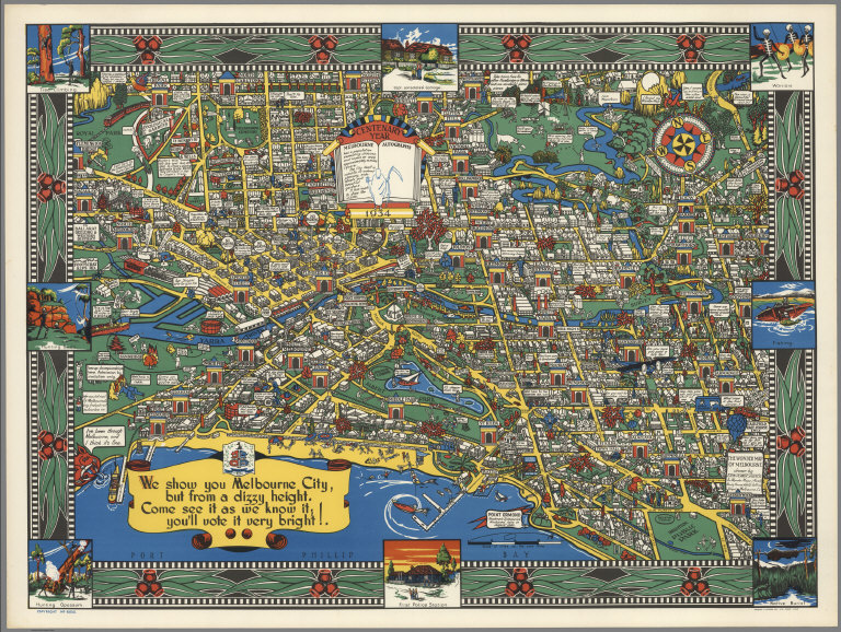
John Power Studios
Full Title
The Wonder Map of Melbourne drawn by John Power Studios.
Publisher
Wonder Maps (Aust.).
Author
[Cartography Associates, Rumsey, David, 1944-, Telemorphic, Inc.]
Full Title
(Lake Tahoe map art mosaic. 2002)
Publisher
Cartography Associates and Telemorphic, Inc.)
Author
[Butler, Lowell, Newbro, William H., Robinson, William W.]
Full Title
A map of the missions, presidios, pueblos, and some of the more interesting ranchos of Spanish California : together with the routes of the principal land explorations therein. Compiled by W. W. Robinson and William H. Newbro, Jr. ; edited by Phil Townsend Hanna ; cartography by Lowell Butler ; Drawings by Ken Sawyer ; color by Harry O. Diamond ; (on lower margin) December 1956, Westways, Vol. 48, No. 12. (insets) San Francisco -Monterey Area ; Los Angeles and vicinity Area.
Publisher
[Westways, Automobile Club of Southern California]
Author
[Butler, Lowell, Webb, William, Hanna, Phil Townsend, 1896-1957]
Full Title
Outdoor play places of California : a cartographic map of some of the outstanding recreational areas of the Golden State : designed by Lowell Butler with descriptive notes by William Webb and Phil Townsed Hanna. Copyright 1954 by the Automobile Club of Southern California. Drawings by Ken Sawyer. Color by Harry O. Diamond. (on lower margin) December 1954, Westways, Vol. 46, No. 12.
Publisher
[Westways, Automobile Club of Southern California]
Author
[Butler, Lowell, Webb, William, Hanna, Phil Townsend, 1896-1957]
Full Title
A Map of the Marked Historical Sites of California : Compiled from the official registrations of the California State Department of Natural Resources : By Phil Townsend Hanna and William Webb : Cartography By Lowell Butler. Copyright 1952 by the Automobile Club of Southern California. Drawing by Gordon Brusstar. Color by Harry Diamond. (on lower margin) December 1952, Westways, Vol. 44, No. 12.
Publisher
[Westways, Automobile Club of Southern California]
Author
Ensign & Thayer
Full Title
Map Of The United States From The Latest Authorities. New York, Published By Ensign & Thayer. 50 Ann St. 1851. Entered ... 1845, by T. & E.H. Ensign ... New York. (inset) Map Of The Western Portion of the United States. (inset) Southern Part Of Florida. (inset) Map Of Oregon.
Publisher
Ensigns & Thayer
Author
[Hammond, John T., Squire, B.S.]
Full Title
Squire's Map Of The State Of New Jersey. Drawn & Engraved by John T. Hammond, New-York, 1836. Entered ... 27th of July 1835 by B.S. Squire Jr. ... New York. (with 8 inset maps).
Publisher
B.S. Squire
Author
Gallatin, Albert
Full Title
Carte des Tribus Indiennnes de l'Amerique du Nord : vers 1600 A.D. ;e long de l'Atlantique ; et vers 1800 A.D. a l'Ouest. D'apres un dessin Mr. Gallatin.
Publisher
No Publisher
Author
[Thurston, Albert G., Rock, Geo H.]
Full Title
Imperial Valley tract map. Published by Western Map & Publishing Co. El Centro and Pasadena. Copyright 1914 by Albert G. Thurston ; drawn by Geo. H. Rock.
Publisher
Western Map and Pub. Co.
Author
[Thurston, Albert G., Rock, Geo H.]
Full Title
Irrigation district and road map, Imperial Valley. Published by Western Map & Publishing Co. El Centro and Pasadena. Copyright 1914 by Albert G. Thurston ; drawn by Geo. H. Rock.
Publisher
Western Map and Pub. Co.
Author
[International Tea Market Expansion Board Limited, Gill, Leslie MacDonald, 1884-1947]
Full Title
Tea. Revives. The. World. MacDonald Gill 1940. Issued by the International Tea Market Expansion Board Limited. Printed in England. S.H.B. Ltd. Regd. No. 4950.
Publisher
International Tea Market Expansion Board Limited
Author
F.A.P. Fine additional Printers
Full Title
Silicon Valley. 1991. F.A.P. Fine Additional Printers. Mountain View.
Publisher
F.A.P.
Author
[Saville, Allen J., Inc., Windsor Farms Inc.]
Full Title
Windsor Farms, a residential development on the James River at Richmond. Henrico Co., Virginia : made for Windsor Farms Inc. Richmond VA. by Allen J. Saville, Inc. Engineering and Construction. Plan by John Nolen - Town Planner; Philip W. Foster - associate Harvard Sq., Cambridge, Mass. Lith. by A Hoen & Co. Richmond VA.
Publisher
A. Hoen & Co.
Author
Bibliographische Institut
Full Title
Map of North America. Karte von Nordamerika. HAPAG. Bibliographische Institut AG. Leipzig. Printed in Germany.
Publisher
Bibliographische Institut AG,
Author
Mouchez, Ernest Amedee Barthelemy
Full Title
Carte de la Republique du Paraguay : cours du Parana et du Paraguay (Amerique meridionale). Dressee par E. Mouchez Lieutt. de Vau. commt. l'Aviso à vapeur le Bisson a l'aide des observations faites et des documents recueillis sur les lieux pendant les trois voyages du Bisson en 1857-58-59. Depot des cartes et plans de la marine. 1862. Paris : Imp. Aug. Bry, R. du Bac 114. PRIX. Grave par Delamare. Deux France.
Publisher
Depot des Cartes et Plans de la Marine
Author
Mouchez, Ernest Amedee Barthelemy
Full Title
Carte de la Partie Meridionale de la Republique du Paraguay. Dressee par E. Mouchez Lieutt. de Vau. commt. l'Aviso à vapeur le Bisson a l'aide des observations faites et des documents recueillis sur les lieux pendant les trois voyages du Bisson en 1857-58-59. Depot des cartes et plans de la marine. 1861. Paris : Imp. Aug. Bry, R. du Bac 114. PRIX. Grave chez Delamare. Deux France.
Publisher
Depot des Cartes et Plans de la Marine
Author
[Randall, Neil, Downs, Timothy Edwards]
Full Title
Road Map to the Best Free Stuff on the Interest.
Publisher
P.C. Computing
Author
Hayden Map Co.
Full Title
Mono County greets you : fisherman's paradise, reached via Bishop, Lee Vining, or Bridgeport. 1955, Map and resort directory of Southern Mono County. Map compiled and published by Hayden Map Co. 211 So. Kenilworth, Glendale, Cal. Copyright 1952- by Hayden Map Co. (inset) Area covered by this map. "Map No. 75555".
Publisher
Hayden Map Co.
Author
Hayden Map Co.
Full Title
(Mono County). 1955 Map and resort directory of Southern Mono County. Map compiled and published by Hayden Map Co. 211 So. Kenilworth, Glendale, Cal. Copyright 1954 Hayden Map Co. (inset) Highway detail. "No. 125655A".
Publisher
Hayden Map Co.
Author
[Ohio Commission to A Century of Progress International Exposition, Sewah Studios]
Full Title
Being a Cartograph of Ohio. The oldest state west of the thirteen original colonies; now the fourth state in the Union in population, third in manufacture; sixth in minerals mined; and among the foremost in agriculture. Published in 1933 by the Ohio. Commission to A Century of Progress International Exposition. Governor George White - Chairman, Charles F. Henry - Director, Charles H. Lewis, Charles F. Williams. Engraving by Bucher Engraving Company. Cartograph by Sewah Studios, Marietta.
Publisher
The Commission
Author
[Clark, Estra, British Railway Executive]
Full Title
A map of Yorkshire produced by British Railways. Estra Clark, 1949. Published by the Railway Executive (Eastern and North Eastern Regions). Waterlow & Sons Ltd., London and Dunstable. Printed in Great Britain. (P.P. 1096).
Publisher
[Railway Executive (Eastern and North Eastern Regions), Waterlow & Sons Ltd.]
Author
[Wylie, Ethel Earle, Van Leer, Ella Wall]
Full Title
A pictorial chart of English literature. Compiled by Ethel Earle Wyle. Illustrated by Ella Wall Van Leer. copyright 1929 by and Ran McNally & Company. Made in U.S.A.
Publisher
Rand McNally & Company
Author
Paine, Paul M.
Full Title
The booklovers' map of the British Isles. Copyright 1927; Paul M. Paine. R. R. Walker Co. 62 W. 45th St. New York N.Y. (on borders) How small the map of Britain is on paper and yet how packed with fancies. (insets) London. (and ) Edinburgh.
Publisher
R.R. Bowker Co.
Author
Paine, Paul M.
Full Title
The map of America's making : For those who would sail with Discoverers, seek Freedom with the Colonists, follow the westward trails, and behold The Building of the Republic, now in its one hundred and fiftieth year. (on lower right corner of map) PM.P. Copyright 1926; Paul M. Paine. R. R. Walker Co. 62 W. 45th St. New York N.Y.
Publisher
R.R. Bowker Co.
Author
Chase, Ernest Dudley, 1878-1966
Full Title
A pictorial map of the British Isles : By Ernest Dudley Chase. Published at Winchester, in the State of Massachusetts, U.S.A. Copyright 1935, Ernest Dudley Chase.
Publisher
Ernest Dedley Chase
Author
Chase, Ernest Dudley, 1878-1966
Full Title
Europe : A pictorial map, by Ernest Dudley Chase of Winchester, Massachusetts, U.S.A. Copyright 1938, Ernest Dudley Chase.
Publisher
Ernest Dedley Chase
|