Who What Where WhenREMOVE |
Author
Bradford, Thomas G.
Full Title
(Title Page Two to) An Illustrated Atlas, Geographical, Statistical, And Historical, Of The United States And The Adjacent Countries. By T.G. Bradford. Boston: Weeks, Jordan, And Company. New York: Wiley And Putnam. (on verso) Entered ... 1838, by Thomas G. Bradford ... Massachusetts. Cambridge: Stereotyped And Printed By Folsom, Wells, And Thurston, Printers To The University.
Publisher
[Weeks, Jordan & Co., Wiley and Putnam.]
Author
[Disturnell, John, Smith, J. Calvin]
Full Title
(Title Page to) The New-York State Guide; Containing An Alphabetical List ... Compiled From Authentic Sources. Albany: Published By J. Disturnell. 1842. (on verso) Entered ... 1842, by John Disturnell ... New-York. Stereotyped And Printed By C. Van Benthuysen. (with) Map of the State of New York Showing the Boundaries of Counties & Townships, the location of Cities, Towns and Villages: Rail Roads, Canals & Stage Roads. By J. Calvin Smith. New York: J. Disturnell, 1842. Engraved on Steel by Sherman & Smith. Entered ... 1842 by J. Calvin Smith ... New York. (with 3 inset maps)
Publisher
J. Disturnell
Author
[Ensigns & Thayer, Phelps, Humphrey]
Full Title
(Title Page to) Phelps's Travellers' Guide Through The United States ... Accompanied With A New Map Of The United States. New-York: Published By Phelps, Ensigns & Thayer, 36 Ann-Street. 1847. (with) Phelps's National Map Of The United States, A Travellers Guide ... New York. Published By Phelps, Ensigns & Thayer ... 1847. Drawn & Engraved by J.M. Atwood, New York. Portraits & St. Arms, Engd. By Wm. D. Smith. Entered ... 1845, by H. Phelps ... N. York. (with 7 inset maps).
Publisher
Phelps, Ensigns & Thayer.
Author
[Ensigns & Thayer, Phelps, Humphrey]
Full Title
(Title Page to) Phelps's Travellers' Guide Through The United States ... Accompanied With A New Map Of The United States. New-York: Published By Ensigns & Thayer, 36 Ann-Street. 1848. (with) Phelps's National Map Of The United States, A Travellers Guide ... New York. Published By Ensigns & Thayer ... 1848. Drawn & Engraved by J.M. Atwood, New York. Portraits & St. Arms, Engd. By Wm. D. Smith. Entered ... 1845, by H. Phelps ... N. York. (with 7 inset maps).
Publisher
Ensigns & Thayer
Author
[Atwood, J.M., Ensign & Thayer]
Full Title
(Title Page to) Ensign & Thayer's Travellers' Guide Through The States Of Ohio, Michigan, Indiana, Illinois, Missouri, Iowa, And Wisconsin ... Accompanied With A New Map Of The Above States. New York: Published By Ensign, & Thayer & Co., 50 Ann Street, And 127 Main St., Buffalo. 1851. (on verso) Entered ... 1848, by Ensigns & Thayer ... New York. (with) Map Of The Western States by J.M. Atwood ... 1851. Published By Ensign & Thayer ... 1851. Drawn & Engraved by J.M. Atwood, N. York. Entered ... 1848 by Ensign's & Thayer ... New York.
Publisher
Ensign, Thayer & Co.
Author
[Cram, George, Farrington, E.C.]
Full Title
(Title Page to) Farrington's Map Of Maine, Together with the Index and Appendix Of Information ... E.C. Farrington, Augusta, Maine. (on verso) Index to State Map Of Maine. (with) Map Of The State Of Maine Showing Railroads, Towns, Plantations and Wild Lands. 1900. 61-63 Plymouth Place, Chicago, Ill. 130 Fulton Street, New York. Revised By Frank E. Oak, State Land Office, Augusta, Me. Copyright 1900 By E.C. Farrington, Augusta, Maine.
Publisher
E.C. Farrington
Author
[Foote, C.M., Henion, J.W.]
Full Title
(Title Page) Plat Book Of Columbia County Wisconsin. Drawn from actual Surveys and the County records by C.M. Foote & J.W. Henion, Surveyors And Draughtsmen. Published By C.M. Foote & Co. 309 Nicollet Avenue. Minneapolis, Minn. 1890. Eng. by Wm. Bracher, 27 So. 6th St. Philad. Printed by F. Bourquin, 31 So. Sixth St. Phila.
Publisher
C.M. Foote & Co.
Author
Higgins, Belden & Co.
Full Title
(Title Page) An Illustrated Historical Atlas Of LaPorte Co. Indiana. Compiled Drawn & Published from Personal Examinations & Surveys by Higgins, Belden & Co. Lakeside Building Corner Clark & Adams Sts. Chicago. 1874. Ed Blue Del.
Publisher
Higgins, Belden & Co.
Author
Wangersheim, W.
Full Title
(Title Page) Atlas And Directory Of Rush County, Indiana. Historical, Educational, Biographical, Miscellaneous. Rushville Publishing Co. Rushville, Ind. 1908.
Publisher
Rushville Publishing Co.
Author
Fay, T.S.
Full Title
(Title Page) Atlas To Fay's Great Outline Of Geography For High Schools And Families, With A Text-Book. New York: G.P. Putnam's Sons, 4th Avenue and 23d Street.
Publisher
G.P. Putnam & Sons
Author
[Beers, S.N., Beers, D.G.]
Full Title
(Title Page) New Topographical Atlas Of St. Lawrence Co. New York From Actual Surveys By S.N. & D.G. Beers And Assistants. Stone & Stewart Publishers, Philadelphia. 1865. Jas. McGuigan lith. S.E. cor. 3rd & Dock St. Philada. Entered ... 1864 by C.K. Stone ... Pennsylvania.
Publisher
Stone & Stewart
Author
[Gross, Alexander, Geographia Map Company]
Full Title
(Title Page to) "Geographia", Atlas of the World : Comprising 33 pages of colored maps, 10 pages of black and white maps, and 8 pages of useful information. Produced under the direction of Alexander Gross. F.R.G.S. Fellow of the Royal Geographical, Royal Economical, Royal Statistical, royal Meteorological and royal Aeronautical Societies. Copyright 1935 by "Geographia" Map Co., 11 John St., New York.
Publisher
Geographia Map Co.
Author
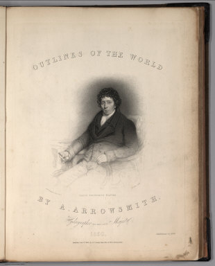
Arrowsmith, Aaron Jr.
Full Title
(Title Page to) Outlines Of The World. By A. Arrowsmith, Hydrographer to His Majesty. 1850. Published Jany st. 1847, by G.F. Cruchley, Mapseller, 81 Fleet Street, London. Addition to 1850. (title page portrait) Aaron Arrowsmith Esquire. H.W. Pickersgill A.R.A. Pinxt. T.A. Dean Sculpt.
Publisher
G.F. Cruchley
Author
Thompson Bro's & Burr
Full Title
(Title Page) Combination Atlas Map Of Will County Illinois. Compiled, Drawn and Published From Personal Examinations and Surveys By Thompson Bro's & Burr. Elgin, Ills. 1873. Duval & Hunter Pr. Phila. N. Friend, Engr. Philad. C.L. Smith, Del.
Publisher
Thompson Bro's & Burr.
Author
Vandermaelen, Philippe, 1795-1869
Full Title
(Title Page to) Atlas universel de geographie physique, politique, statistique et mineralogique, sur l'echelle de 1/1641836 ou d'une ligne par 1900 toises, dresse par Ph. Vandermaelen, Membre de la Societe de Geographie de Paris, d'apres les meilleures cartes, observations astronomiques et voyages dans les divers Pays de la Terre; Lithographie par H. Ode, Membre de la Societe de Geographie de Paris. Premier partie. - Europe. Bruxelles. 1827.
Publisher
Ph. Vandermaelen
Author
Vandermaelen, Philippe, 1795-1869
Full Title
(Title Page to) Atlas universel de geographie physique, politique, statistique et mineralogique, sur l'echelle de 1/1641836 ou d'une ligne par 1900 toises, dresse par Ph. Vandermaelen, Membre de la Societe de Geographie de Paris, d'apres les meilleures cartes, observations astronomiques et voyages dans les divers Pays de la Terre; Lithographie par H. Ode, Membre de la Societe de Geographie de Paris. Deuxieme partie. - Asie. Bruxelles. 1827.
Publisher
Ph. Vandermaelen
Author
Vandermaelen, Philippe, 1795-1869
Full Title
(Title Page to) Atlas universel de geographie physique, politique, statistique et mineralogique, sur l'echelle de 1/1641836 ou d'une ligne par 1900 toises, dresse par Ph. Vandermaelen, Membre de la Societe de Geographie de Paris, d'apres les meilleures cartes, observations astronomiques et voyages dans les divers Pays de la Terre; Lithographie par H. Ode, Membre de la Societe de Geographie de Paris. Troisieme partie. - Afrique. Bruxelles. 1827.
Publisher
Ph. Vandermaelen
Author
[Andree, Richard, Times (London, England)]
Full Title
(Title Page to) The Times Atlas ; (New Edition). Containing 132 Pages of Maps, and comprising 196 Maps and an Alphabetical Index to 150,000 Names. Published at the Office of The Times, Printing House Square, London, E.C. 1900.
Publisher
The Office of The Times
Author
Vandermaelen, Philippe, 1795-1869
Full Title
(Title Page to) Atlas universel de geographie physique, politique, statistique et mineralogique, sur l'echelle de 1/1641836 ou d'une ligne par 1900 toises, dresse par Ph. Vandermaelen, Membre de la Societe de Geographie de Paris, d'apres les meilleures cartes, observations astronomiques et voyages dans les divers Pays de la Terre; Lithographie par H. Ode, Membre de la Societe de Geographie de Paris. Cinquieme partie. - Amer. merid. Bruxelles. 1827.
Publisher
Ph. Vandermaelen
Author
Vandermaelen, Philippe, 1795-1869
Full Title
(Title Page to) Atlas universel de geographie physique, politique, statistique et mineralogique, sur l'echelle de 1/1641836 ou d'une ligne par 1900 toises, dresse par Ph. Vandermaelen, Membre de la Societe de Geographie de Paris, d'apres les meilleures cartes, observations astronomiques et voyages dans les divers Pays de la Terre; Lithographie par H. Ode, Membre de la Societe de Geographie de Paris. Sixieme partie. - Oceanique. Bruxelles. 1827.
Publisher
Ph. Vandermaelen
Author
Mexico. Direccion de Estudios Geográficos y Climatologicos
Full Title
(Title Page 1) Atlas geografico de la Republica Mexicana : Secretaria de Agricultura y Fomento : Direccion de Estudios Geograficos y Climatologicos 1919-1921.
Publisher
Direccion de Estudion Geograficos y Climatologicos
Author
Mexico. Direccion de Estudios Geográficos y Climatologicos
Full Title
(Title Page 2) Tipos y signos convencionales usados en el Atlas geografico de la Republica Mexicana : construido y editado en la Direccion de Estudios Geograficos y Climatologicos.
Publisher
Direccion de Estudion Geograficos y Climatologicos
Author
[Walker, G.H., Walker, O.W.]
Full Title
(Title Page) Atlas Of Massachusetts. Compiled Under The Direction Of O.W. Walker, C.E. Assistance rendered by more than One Hundred prominent Civil Engineers and Surveyors, referred to on Page 3. Published By Geo. H. Walker & Co. 160 Tremont St. Boston, Mass. Copyright 1891, by Geo. H. Walker & Co., Boston. (in fountain ink) 1891.
Publisher
Geo.H. Walker & Co.
Author
Davis, F.A.
Full Title
(Title Page to) New Illustrated Atlas Of Lehigh County, Pennsylvania. Compiled & Drawn from Personal Examinations, Surveys & Under the Personal Supervision of F.A. Davis. and Published under the Superintendence of H.L. Kochersperger By The Reading Publishing House, Reading, Pa. A.M. Davis Successor to F.A. Davis & Co. 1876. Copyright 1876, By O.W. Gray & Son, & F.A. Davis & Co. Maps & Atlases Plain and Colored Lithographing Engraving on Wood or Stone ... Historical Works & Charts ...
Publisher
Reading Publishing House
Author
Mitchell, Samuel Augustus Jr.
Full Title
(Title Page to) Mitchell's New General Atlas, Containing Maps Of The Various Countries Of The World, Plans Of Cities, Etc., Embraced In Seventy-Nine Quarto Maps, Forming A Series Of One Hundred and Twelve Maps and Plans, Together With Valuable Statistical Tables. Also, A List Of Post-Offices Of The United States And Territories, And Census Of 1860 And 1870. Philadelphia: Published By S. Augustus Mitchell, No. 31 South Sixth Street. 1874. Entered ... 1874, by S. Augustus Mitchell ... Washington.
Publisher
S.A. Mitchell Jr.
Author
[Great Britain. Ordnance Survey, Mudge, William (1762-1820), Colby, Thomas, Baker, Benjamin, Great Britain. Board of Ordnance]
Full Title
Title sheet for Devon, The Second Part of the General Survey of England and Wales.
Publisher
[W. Mudge; Ordnance Survey, Thomas Colby (1784-1852)]
Author
Johnson, A.J.
Full Title
(Title Page to) Johnson's New Illustrated (Steel Plate) Family Atlas, With Descriptions, Geographical, Statistical, And Historical. Compiled, Drawn, and Engraved Under The Supervision Of J.H. Colton And A.J. Johnson. New York: Johnson And Browning, Formerly (Successors To J.H. Colton And Company,) No. 133 Nassau Street. 1860. Entered ... One Thousand Eight Hundred and Sixty, by Johnson & Browning ... Virginia.
Publisher
Johnson and Browning
Author
Thompson, Thos. H.
Full Title
(Title Page to) Official historical atlas map of Fresno County. Office of the Board of Supervisors of Fresno County, California ... Compiled, drawn and published from personal examinations and surveys by Thos. H. Thompson, Tulare, California, 1891.
Publisher
Thompson Thos. H.
Author
Breese, Sidney
Full Title
(Title Page to) Reports of Committees, Printed by Order of the Senate of the United States, during the Second Session of the Thirtieth Congress, begun and held at the City of Washington, December 4, 1848 ... Containing Reports from No. 244 to No. 331. Washington: 1849. Accompanied with Skeleton Map Showing the Railroads completed and in Progress in the United States, and those projected through the Public Lands and their connection with the principal Harbours on the Lakes and on the Seaboard. Printed by order of the Senate of the United States the 9th Sess: 31st Congress 1848-9.
Publisher
C.B. Graham's Lithy.
Author
[Ludlow, William, 1843-1901, United States. Army. Corps of Engineer]
Full Title
(Title Page to) Engineering Department, U.S. Army. Report of a reconnaissance of the Black Hills of Dakota, made in the summer of 1874. By William Ludlow, Captain of Engineers, Bvt. Lieut. Colonel, U. S. Army; Chief Engineer Department of Dakota. Washington : Government Printing Office. 1875.
Publisher
Government Printing Office
Author
Ludlow, William
Full Title
(Title Page to) Report of a Reconnaissance From Carroll, Montana Territory, on the Upper Missouri, to the Yellowstone National Park, and Return Made in the Summer of 1875, by William Ludlow ... Washington: Government Printing Office. 1876.
Publisher
[N. Peters, Government Printing Office]
Author
Powell, John Wesley, 1834-1902.
Full Title
(Title Page to) Report on the Lands of the Arid Region of the United States, with a More Detailed Account of the Lands of Utah. With Maps. By J.W. Powell. Second edition. Washington: Government Printing Office. 1879.
Publisher
Government Printing Office
Author
[France. Armee. Genie, Jacotin, Pierre, 1765-1827]
Full Title
(Title Page to) Carte topographique de l'Egypte et de plusieurs parties des pays limitrophes, levee pendant l'Expedition de l'Armee francaise, par les ingenieurs-geographes, les officiers du Genie Militaire et les ingenieurs des ponts et chausees, assujettie aux observations des astronomes, construite par M. Jacotin, Colonel au Corps Royal des Ingenieurs-Geographes Militaires ... Gravee au Depot General de la Guerre, a l'echelle de 1 millimetre pour 100 metres. Publiee par ordre du gouvernement. Paris [1826]
Publisher
C.L.F. Panckoucke
Author
Glassford, W.A.
Full Title
(Title Page to) Letter from the Secretary of War, transmitting letter of the chief signal officer on the Rain-Fall On The Pacific Slope and the Western states and Territories. February 27, 1888, -- Ordered to be printed and laid upon the table. Washington: Government Printing Office. 1888. (at head of title) 50th Congress, 1st Session. Ex. Doc. No.91. (with) Charts and Tables of Rain-Fall On The Pacific Slope, With A Discussion of The Causes of The Wet and Dry Seasons, The Abundance and Deficiency in Different Portions, The Summer Rainy Season in Arizona, Etc. By W.A.Glassford ...
Publisher
Government Printing Office
Author
Glassford, W.A.
Full Title
(Title Page to) Charts and Tables of Rain-Fall On The Pacific Slope, With A Discussion of The Causes of The Wet and Dry Seasons, The Abundance and Deficiency in Different Portions, The Summer Rainy Season in Arizona, Etc. By W.A.Glassford ... (with) Letter from the Secretary of War, transmitting letter of the chief signal officer on the Rain-Fall On The Pacific Slope and the Western states and Territories. February 27, 1888, -- Ordered to be printed and laid upon the table. Washington: Government Printing Office. 1888. (at head of title) 50th Congress, 1st Session. Ex. Doc. No.91.
Publisher
Government Printing Office
Author
Tehuantepec Railway Company
Full Title
(Title Page to) The Tehuantepec Railway, Its Location, Features and Advantages Under the La Sere Grant of 1869. D. Appleton & Co ... 1869. (on verso) Entered ... 1869, by The Tehuantepec Railway Company ... New York. Baker & Godwin, Printers, Printing House Square, N.Y.
Publisher
D. Appleton & Co.
Author
Mitchell, Samuel Augustus Jr.
Full Title
(Title Page to) Mitchell's New General Atlas, Containing Maps Of The Various Countries Of The World, Plans Of Cities, Etc., Embraced In Eighty-Three Quarto Maps, Forming A Series Of One Hundred and Forty Maps and Plans, Together With Valuable Statistical Tables. Also, A List Of Post-Offices Of The United States And Territories, And Census Of 1860 And 1870. Philadelphia: Published By S. Augustus Mitchell, No. 31 South Sixth Street. 1877. Entered ... 1877, by S. Augustus Mitchell ... Washington.
Publisher
S.A. Mitchell Jr.
Author
Delamarche, Felix
Full Title
(Title Page) Atlas De La Geographie Ancienne et moderne, Adopte Par Le Conseil Royal De l'Instruction Publique, A l'usage des Colleges Royaux et des Maisons d'Education, pour suivre les Cours de Geographie et D'Histoire; Par Felix Delamarche, Successeur De Robert De Vaugondy, Geographe Du Roi. A Paris, Chez Felix Delamarche, Ingenieur-Mecanicien Pour Les Globes Et Spheres, Rue du Jardinet, No. 13. 1826. (Annee Scolaire.)
Publisher
F. Delamarche
Author
Mellish, John
Full Title
(Title Page to) An Atlas Of Ten Select Maps Of Ancient Geography Both Sacred And Profane; With A Chronological Table Of Universal History & Biography. Being Intended As An Accompaniment To Mayo's Ancient Geography And History. Calculated For The Use Of Seminaries, &c. Philadelphia: Published By John Mellish (sic), No. 49 South Third Street, And Sold By The Principal Booksellers In The United States. 1815.
Publisher
John Mellish
Author
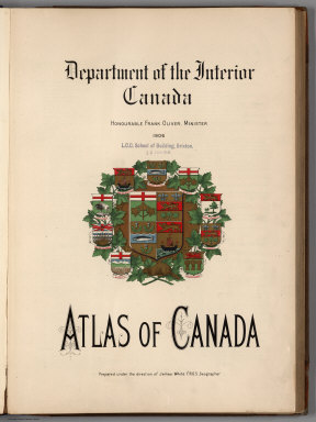
[White, James, Canada. Department of Interior]
Full Title
(Title Page to) Department of the Interior, Canada. Honorable Frank Oliver, Minister, 1906. Atlas of Canada. Prepared under the direction of James White, F.R.G.S., Geographer. (on verso) The Toronto Lithographing Company, Limited; Map engravers, and dedication note.
Publisher
Department of Interior
Author
Lothian, John
Full Title
(Title Page) The People's Atlas, Shewing The Relative Extent And Divisions, The Boundaries, And Other Geographical Details Of The Various Empires, States, And Quarters Of The World, Agreeably To The Best Authorities, And In Accordance With A Comparative View Of The Heights Of Hills And Lengths Of Rivers, Revised By J. Lothian. Glasgow: James Macleod, 20 Argyle Street, And Francis Orr & Sons, William Tait, Edinburgh; Simpkin, Marshall, & Co. London; A. Heywood, Manchester; And J. Cumming, Dublin. MDCCCXLVIII.
Publisher
James MacLeod and Francis Orr & Sons
Author
Meacham, J.H. & Co.
Full Title
(Title Page) Illustrated Historical Atlas Of Pictou County Nova Scotia. Dedicated by Special Permission to His Excellency Sir John Douglas Sutherland Campbell K.T.K.M.K.G. Gov. General &c. By J.H. Meacham & Co. Publishers 1879. C.R. Allen, Civil Engineer. Eng. by Worley & Bracher, 27 So. Sixth St. Phila. Pa. Printed by F. Bourquin, 31 So. Sixth St. Phila. Pa.
Publisher
J.H. Meacham & Co.
Author
Raynolds, W.F.
Full Title
(Title Page to) Report of the Secretary of War, communicating ... the report of Brevet Brigadier General W.F. Raynolds, on the exploration of the Yellowstone and the country drained by that river. (Senate. 40th Congress, 2nd session, Ex. Doc. No. 77.) July 19, 1867. - Read; ordered to lie on the table.
Publisher
War Dept.
Author
Mitchell, Samuel Augustus
Full Title
(Title Page) A New Universal Atlas Containing Maps of the various Empires, Kingdoms, States and Republics Of The World. With a special map of each of the United States, Plans of Cities &c. Comprehended in seventy sheets and forming a series of One Hundred And Seventeen Maps, Plans And Sections ... Philadelphia, Published By Thomas, Cowperthwait & Co. No. 253 Market Street. 1850. Entered ... 1850, by Thomas, Cowperthwait & Co. ... Pennsylvania. (title page by) J. Knight Sc.
Publisher
Thomas, Cowperthwait & Co.
Author
Delamarche, Felix.
Full Title
(Title Page) Atlas De La Geographie Ancienne, Du Moyen Age, Et Moderne, Adopte Par Le Conseil Royal De L'Universite, A L'Usage Des Colleges Royaux Et Des Maisons D'Education, pour suivre les Cours de Geographie et d'Histoire; Par Delamarche, Successeur de Robert De Vaugondy, geographe du Roi. Paris, Librairie Geographique Delamarche, Rue Du Battoir, No. 7, Ci-Devant Rue Du Jardinet. Annee Scolaire. 1847. (on verso) ... Imprimerie Schneider et Langrand, rue d'Erfurth, 1.
Publisher
F. Delamarche
Author
Society for the Diffusion of Useful Knowledge (Great Britain)
Full Title
(Title Page) The Family Atlas Containing Eighty Maps, Constructed By Eminent Geographers, And Engraved On Steel, Under The Superintendence Of The Society For The Diffusion Of Useful Knowledge (SDUK), Including The Geological Map Of England And Wales, By Sir I. Murchison, F.R.S., The Star Maps By Sir John Lubbock, Bart. And The Plans Of London And Paris, With The New Discoveries And Other Improvements To The Latest Date. And An Alphabetical Index. London: Edward Stanford, 6, Charing Cross. 1865.
Publisher
Edward Stanford
Author
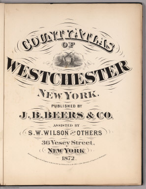
Beers, J.B.
Full Title
(Title Page) County Atlas Of Westchester New York. Published By J.B. Beers & Co. Assisted By S.W. Wilson And Others, 36 Vesey Street, New York. 1872. Entered ... 1872 by J.B. Beers & Co. ... Washington.
Publisher
J.B. Beers & Co.
Author
Mitchell, Samuel Augustus
Full Title
(Title Page to) A New Universal Atlas Containing Maps of the various Empires, Kingdoms, States and Republics Of The World. With a special map of each of the United States, Plans of Cities &c. Comprehended in eighty one sheets and forming a series of One Hundred And Forty Five Maps, Plans And Sections ... Philadelphia, Charles Desilver, No. 251 Market Street. 1857. Entered ... 1856 by Charles Desilver ... Pennsylvania. (title page by) Barralet del. Humphreys, sc. J. Knight Sc.
Publisher
Charles DeSilver
Author
[Raynal, G.T., Bonne, R.]
Full Title
(Title Page to) Atlas De Toutes Les Parties Connues Du Globe Terrestre, Dresse Pour L'Histroire Philosophique et Politique des Etablissemens et du Commerce des Europeens dans les Deux Indes. (to accompany) Histoire Philosophique et Politique Des Establissements et Du Commerce Des Europeens Dans Les Deux Indes.
Publisher
Jean-Leonard Pellet
|